Related Research Articles

Blackstone is a town in Worcester County, Massachusetts, United States. The population was 9,208 at the 2020 census. It is a part of the Providence metropolitan area.

Route 99, also known as the Woonsocket Industrial Highway, is a 2.9-mile-long (4.7 km) freeway in Providence County, Rhode Island, United States. Route 99 serves Manville and the Highland Industrial Park, providing freeway access to the city of Woonsocket from Rhode Island Route 146, which bypasses the city. The southern terminus of Route 99 is at a partial interchange with Route 146 in Lincoln. The freeway has one interchange in Manville, a village in Lincoln, before terminating at an at-grade intersection with Rhode Island Route 122 in Woonsocket.

The New York and New England Railroad (NY&NE) was a railroad connecting southern New York State with Hartford, Connecticut; Providence, Rhode Island; and Boston, Massachusetts. It operated under that name from 1873 to 1893. Prior to 1873 it was known as the Boston, Hartford and Erie Railroad, which had been formed from several smaller railroads that dated back to 1846. After a bankruptcy in 1893, the NY&NE was reorganized and briefly operated as the New England Railroad before being leased to the competing New York, New Haven and Hartford Railroad in 1898.

Route 140 is a 107.76-mile-long (173.42 km) north—south state highway which passes through Bristol, Norfolk and Worcester counties in Massachusetts. The highway follows a southeast-northwest trajectory, running from U.S. Route 6 in New Bedford just north of Buzzards Bay northwest to an intersection with Route 12 in Winchendon, a few miles south of the border with New Hampshire.

The Roxbury Conglomerate, also informally known as Roxbury puddingstone, is a name for a rock formation that forms the bedrock underlying most of Roxbury, Massachusetts, now part of the city of Boston. The bedrock formation extends well beyond the limits of Roxbury, underlying part or all of Quincy, Canton, Milton, Dorchester, Dedham, Jamaica Plain, Brighton, Brookline, Newton, Needham, and Dover. It is named for exposures in Roxbury, in the Boston area. It is the Rock of the Commonwealth in Massachusetts.

The Southern New England Trunkline Trail (SNETT) is a rail trail in Massachusetts. The trail passes through the towns of Douglas, Uxbridge, Millville, Blackstone, Bellingham, and Franklin and is one of the longest trails in southern Massachusetts. It is designated for use by pedestrians, equestrians and non-motorized vehicles, with motorized off-road vehicles excluded.

Route 126 is a 33.5704-mile-long (54.0263 km) north–south state highway in Massachusetts. Its southern terminus is a continuation of Rhode Island Route 126 by Woonsocket, Rhode Island and its northern terminus is at Route 2 and Route 2A in Concord. Along the way it intersects several major routes including Interstate 495 (I-495) in Bellingham, Route 9 in Framingham, and U.S. Route 20 in Wayland.

Franklin/Dean College station is an MBTA Commuter Rail station located in Franklin, Massachusetts, near Dean College. It serves the Franklin/Foxboro Line, for which it was the terminus from 1966 to 1988. The station has a mid-sized park and ride lot to serve town residents; Forge Park/495 station is intended to serve commuters from other nearby towns. The 1912-built station building still serves as a waiting hall and café, open during morning commute hours on weekdays. Franklin/Dean College station has a single side platform serving the line's single track; it is not accessible.
The Call is an American daily newspaper published seven days per week in Woonsocket, Rhode Island, covering northern Providence County, Rhode Island, and some adjacent towns in Massachusetts.
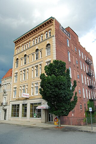
The Times is an American daily newspaper published Mondays through Saturdays in Pawtucket, Rhode Island, covering eastern Providence County, Rhode Island, and some adjacent towns in Massachusetts. It was owned by RISN Operations and is currently owned by Triboro Massachusetts News Media.
Breeze Publications is a privately owned publisher based in Lincoln, Rhode Island, serving northern and western Providence County with five free tabloid-format weekly newspapers.
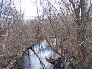
The Peters River is a river in the U.S. states of Massachusetts and Rhode Island. It flows 7.0 miles (11.3 km).

The Mill River is a river in the U.S. states of Massachusetts and Rhode Island. It flows approximately 17.1 miles (27.5 km).
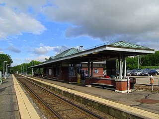
Forge Park/495 station is a Massachusetts Bay Transportation Authority (MBTA) commuter rail station served by the Franklin/Foxboro Line. It is located off Route 140 near Interstate 495 in Franklin, Massachusetts, United States. A park and ride station serving southwestern Boston suburbs and northeastern Rhode Island, it is the outer terminus of the Franklin/Foxboro Line. The station has two side platforms serving a single track, with an accessible mini-high platform and a station building on the south platform.

Fall River granite is a Precambrian bedrock underlying the City of Fall River, Massachusetts and surrounding areas along the eastern shores of Narragansett Bay. It was formed 600 million years ago, as part of the Avalon terrane.

Bellingham is a town in Norfolk County, Massachusetts, United States. The population was 16,945 at the 2020 census. The town sits on the southwestern fringe of Metropolitan Boston, along the rapidly growing "outer belt" that is Interstate 495. It is formally a part of the Boston–Cambridge–Quincy metropolitan statistical area, as well as the Providence metropolitan area.

The geology of Massachusetts includes numerous units of volcanic, intrusive igneous, metamorphic and sedimentary rocks formed within the last 1.2 billion years. The oldest formations are gneiss rocks in the Berkshires, which were metamorphosed from older rocks during the Proterozoic Grenville orogeny as the proto-North American continent Laurentia collided against proto-South America. Throughout the Paleozoic, overlapping the rapid diversification of multi-cellular life, a series of six island arcs collided with the Laurentian continental margin. Also termed continental terranes, these sections of continental rock typically formed offshore or onshore of the proto-African continent Gondwana and in many cases had experienced volcanic events and faulting before joining the Laurentian continent. These sequential collisions metamorphosed new rocks from sediments, created uplands and faults and resulted in widespread volcanic activity. Simultaneously, the collisions raised the Appalachian Mountains to the height of the current day Himalayas.

The Milford Secondary is a railroad line that runs between Franklin and Milford, Massachusetts, United States.

The Norfolk Basin is synclinal basin, partially bounded by faults, running east-northeast between the Dedham Block and the Foxborough Block. It contains the folded and cleaved, but unmetamorphosed Wamsutta Formation and Pondville Conglomerate, which both formed in the Pennsylvanian, also known as the Late Carboniferous 323 to 298 million years ago. The middle of the basin is close to the village of Pondville.

The geology of Rhode Island is based on nearly one billion year old igneous crystalline basement rocks formed as part of the microcontinent Avalonia that collided with the supercontinent Gondwana. The region experienced substantial folding associated with its landlocked position during the Alleghanian orogeny mountain building event. The region accumulated sedimentary rocks, including small deposits of coal. The region was covered with thick Atlantic Coastal Plain sediments, with the erosion of the Appalachians and the creation of the Atlantic Ocean throughout the past 200 million years. These surficial sediments and soils were substantially reworked by the Pleistocene glaciations. The state's geology is part of the broader geology of New England.
References
- ↑ Goldsmith, Richard (1991). Stratigraphy of the Milford-Dedham Zone, Eastern Massachusetts: An Avalonian Terrane. USGS. p. E34.
| | This Massachusetts state location article is a stub. You can help Wikipedia by expanding it. |