Related Research Articles

The City of Greater Bendigo is a local government area in Victoria, Australia, located in the central part of the state. It covers an area of 3,000 square kilometres (1,200 sq mi) and, in June 2021, had a population of 123,632. It includes the city of Bendigo and the towns of Axedale, Elmore, Heathcote, Marong, Raywood and Strathfieldsaye. It was formed in 1994 from the amalgamation of the former City of Bendigo with the Borough of Eaglehawk, Shire of Strathfieldsaye, Shire of Huntly, Rural City of Marong and parts of the Shire of McIvor. It is the state’s third largest economy base and is considered a service and infrastructure centre for north central Victoria. The city is surrounded by 40,000 hectares of regional, state and national parkland.

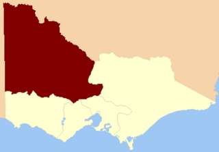
The Division of Bendigo is an Australian electoral division in the state of Victoria. The division was proclaimed in 1900, and was one of the original 65 divisions to be contested at the first federal election. It is named for the city of Bendigo.

Bendigo East is an electoral district of the Legislative Assembly in the Australian state of Victoria. It covers an area of 2,711 square kilometres (1,047 sq mi) covering the part of the city of Bendigo east of the Yungera railway line and surrounding rural areas to the north, east and south. It includes the Bendigo suburbs of East Bendigo, Epsom, Flora Hill, Junortoun, Kennington, Quarry Hill, Spring Gully, Strathdale, Strathfieldsaye and White Hills, and the surrounding towns of Axedale, Goornong, Huntly, Mandurang, Raywood and Sedgwick. It also includes parts of the localities of Eaglehawk, Elmore, Golden Square and Ravenswood, and the Bendigo campus of La Trobe University. It lies within the Northern Victoria Region of the upper house, the Legislative Council.
Electoral district of Korong and Eaglehawk was an electoral district of the Legislative Assembly in the Australian state of Victoria.

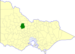
The Shire of Huntly was a local government area immediately to the northeast of the regional city of Bendigo, Victoria, Australia. The shire covered an area of 878 square kilometres (339.0 sq mi), and existed from 1866 until 1994. The shire had its origins in the creation of the Camapaspe Road District in 1861. The road district was renamed and redesignated as Huntly shire in 1866.
The Shire of McIvor was a local government area about 110 kilometres (68 mi) north of Melbourne, the state capital of Victoria, Australia. The shire covered an area of 1,295 square kilometres (500.0 sq mi), and existed from 1863 until 1994.

The Shire of Metcalfe was a local government area about 105 kilometres (65 mi) north-northwest of Melbourne, the state capital of Victoria, Australia, and 45 kilometres (28 mi) south of the regional city of Bendigo. The shire covered an area of 590.52 square kilometres (228.0 sq mi), and existed from 1860 until 1995.
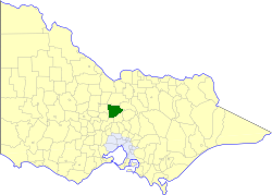
The Shire of Strathfieldsaye was a local government area immediately to the east and southeast of the regional city of Bendigo, Victoria, Australia, and included the eastern suburbs of Bendigo's metropolitan area. The shire covered an area of 601.34 square kilometres (232.2 sq mi), and existed from 1861 until 1994.
The City of Bendigo was a local government area covering the central area and inner western suburbs of the regional city of Bendigo, Victoria, Australia. The city covered an area of 32.53 square kilometres (12.6 sq mi) and existed from 1855 to 1994.
The Borough of Eaglehawk was a local government area which covered the northwestern suburbs of the regional city of Bendigo, Victoria, Australia. The borough covered an area of 14.54 square kilometres (5.6 sq mi), and existed from 1862 until 1994.

The City of Echuca was a local government area of Victoria, Australia, about 200 kilometres (124 mi) north of Melbourne, the state capital, in the regional centre of Echuca, on the Murray River. The city covered an area of 26.06 square kilometres (10.1 sq mi), and existed from 1865 until 1994.

The City of Castlemaine was a local government area about 120 kilometres (75 mi) north-northwest of Melbourne, the state capital of Victoria, Australia, and 38 kilometres (24 mi) south of the regional city of Bendigo. The city covered an area of 23.31 square kilometres (9.0 sq mi) and it existed from 1855 until 1995.
The electoral district of Bendigo was an electorate of the Victorian Legislative Assembly in the Australian state of Victoria. Centred on the city of Bendigo, the district was formed when the electorates of Bendigo East and Bendigo West were merged into a single district in 1927. Bendigo was abolished in 1985 when it was once again split into separate East and West districts.
Northern Province was an electorate of the Victorian Legislative Council (Australia),
North Western Province was an electorate of the Victorian Legislative Council (Australia), created in 1856 and was abolished in 2006.
North Central Province was an electorate of the Victorian Legislative Council (Australia). It was created in the redistribution of provinces in 1882 when the Central and Eastern Provinces were abolished. The new North Central Province, South Yarra, North Yarra, South Eastern and Melbourne Provinces were then created.
Wellington Province was an electorate of the Victorian Legislative Council, the upper house of the Victorian Parliament.
Melbourne South Province was an electorate of the Victorian Legislative Council. It was created in June 1904 when Melbourne Province was reduced in size and North Yarra Province and South Yarra Province were abolished. The new Melbourne South, Melbourne North, Melbourne East and Melbourne West Provinces were then created.

Castlemaine was an electoral district of the Legislative Assembly in the Australian state of Victoria from 1859 to 1904. It included the towns of Castlemaine, Muckleford and Harcourt.
The Electoral district of Sandhurst was an electoral district of the old unicameral Victorian Legislative Council of 1851 to 1856. Victoria being a colony in Australia at the time. Sandhurst was added to the Council in 1855, along with four other districts.
References
- 1 2 "Re-Member (Former Members)". State Government of Victoria. Retrieved 10 May 2013.
- ↑ Edward Sweetman (1920). Constitutional Development of Victoria, 1851-6. Whitcombe & Tombs Limited. p. 182. Retrieved 19 October 2012.
| | This Victoria (Australia) government-related article is a stub. You can help Wikipedia by expanding it. |