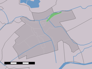
West Maas en Waal is a municipality in the Dutch province of Gelderland.
Papendrecht is a town and municipality in the western Netherlands, in the province of South Holland, at the crossing of the River Beneden Merwede and the Noord River. The municipality had a population of 32,256 in 2017 and covers an area of 10.79 km2 (4.17 sq mi) of which 1.31 km2 (0.51 sq mi) is water.

Vlist is a village and former municipality in the western Netherlands, in the province of South Holland. As of 2015, it is a part of the municipality of Krimpenerwaard.

Zwijndrecht is a town and municipality in the western Netherlands. It is located in the province of South Holland, at the southern tip of the island of IJsselmonde, and at the confluence of the rivers Oude Maas, Beneden-Merwede, and Noord.

The Beneden Merwede is a stretch of river in the Netherlands, mainly fed by the river Rhine. It starts as the continuation of the Boven Merwede after the branching-off of the Nieuwe Merwede ship canal. It flows from Hardinxveld-Giessendam to Dordrecht, where it splits into the Noord and Oude Maas rivers. Its length is 14.8 km. The river is part of the main shipping route between the port of Rotterdam and the industrial region of the Ruhr, Germany.
The Nieuwe Merwede is a canal, mainly fed by the river Rhine, that was constructed in 1870 to form a branch in the Rhine-Meuse delta. It was dug along the general trajectories of a number of minor Biesbosch creeks to reduce the risk of flooding by diverting the water away from the Beneden Merwede, and to facilitate navigation and regulate river traffic in the increasingly silted-up delta.
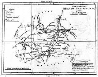
Meuse-Inférieure was a department of the First French Empire in present-day Belgium, Netherlands and Germany. It was named after the river Meuse. Its capital was Maastricht. Its territory corresponded largely with the present-day provinces of Belgian and Dutch Limburg.

Bouches-de-la-Meuse was a department of the First French Empire in the present-day Netherlands. It was named after the mouth of the river Meuse. It was formed in 1810, when the Kingdom of Holland was annexed by France. Its territory corresponded more or less with the present-day Dutch province of South Holland. Its capital was The Hague.
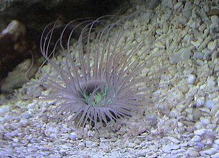
Tube-dwelling anemones or ceriantharians look very similar to sea anemones but belong to an entirely different subclass of anthozoans. They are solitary, living buried in soft sediments. Tube anemones live inside and can withdraw into tubes, which are composed of a fibrous material made from secreted mucus and threads of nematocyst-like organelles known as ptychocysts. Ceriantharians were formerly classified in the taxon Ceriantipatharia along with the black corals but have since been moved to their own subclass, Ceriantharia.

Haastrecht is a town on the Hollandse IJssel river in the Dutch province of South Holland. It is a part of the municipality of Krimpenerwaard, and lies about 5 km east of Gouda.
Boven-Haastrecht is a town in the Dutch province of South Holland, where it is a part of the municipality of Krimpenerwaard lying about 6 km east of Gouda.

Stein is a small village in the Dutch province of South Holland. It is a part of the municipality of Krimpenerwaard, and lies about 5 km east of Gouda.
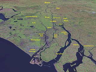
The Merwede is the name of several connected stretches of river in The Netherlands, between the cities of Woudrichem, Dordrecht and Papendrecht. The river is part of the Rhine–Meuse–Scheldt delta and is mostly fed by the river Rhine.

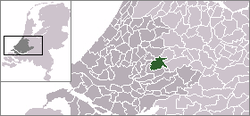
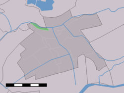
Beneden-Leeuwen is a town in the Dutch province of Gelderland. It is a part of the municipality of West Maas en Waal, and lies about 7 km east of Tiel, on the opposite (southern) bank of the river Waal.

Edith van Dijk is a Dutch swimmer and 6-fold world champion. She is Holland's most successful open water swimmer and long distance swimmer, whose career started in 1990 taking part in the Dutch IJsselmeermarathon.
The Land van Arkel was a fief of the Counts of Holland, and was managed by the Lords of Arkel until 1412. The territory was bordered by the river Merwede on the south, and the river Linge on the east. The northern border might have reached as far as Everdingen, and the western border to the river Lek. Present day towns in the territory include Leerdam, Arkel, Heukelum, Asperen, Hagestein, Haastrecht and Gorinchem.
John V, Lord of Arkel was Lord of Arkel, Haastrecht and Hagestein and stadtholder of Holland, Zeeland and West Frisia. He was a son of Lord Otto of Arkel and his wife, Elisabeth of Bar-Pierrepont.
The Steenenhoek Canal is a Dutch canal in southeastern Netherlands.

De Wielewaal is a tower mill in Beneden-Leeuwen, Gelderland, Netherlands which was built in 1857 and is in working order. The mill is listed as a Rijksmonument.