Beni Oulbane

Last updated
Beni Oulbane
Commune and town
CountryFlag of Algeria.svg  Algeria
Province Skikda Province
Time zone CET (UTC+1)

Beni Oulbane is a town and commune in Skikda Province in north-eastern Algeria. [1]

Communes of Algeria administrative division of Algeria

The municipalities of Algeria form the second level of administrative subdivisions of Algeria. As of 2002, there were 1,541 municipalities in the country.

Skikda Province Province in Algeria

Skikda is a province (wilaya) of Algeria, on its eastern Mediterranean coastline.

Algeria country in North Africa

Algeria, officially the People's Democratic Republic of Algeria, is a country in the Maghreb region of North Africa. The capital and most populous city is Algiers, located in the far north of the country on the Mediterranean coast. With an area of 2,381,741 square kilometres (919,595 sq mi), Algeria is the tenth-largest country in the world, and the largest in Africa. Algeria is bordered to the northeast by Tunisia, to the east by Libya, to the west by Morocco, to the southwest by the Western Saharan territory, Mauritania, and Mali, to the southeast by Niger, and to the north by the Mediterranean Sea. The country is a semi-presidential republic consisting of 48 provinces and 1,541 communes (counties). It has the highest human development index of all non-island African countries.

Related Research Articles

Souk-Oufella Place in Béjaïa, Algeria

Souk-Oufella is a town in northern Algeria.

Strzyże, Pułtusk County Village in Masovian, Poland

Strzyże is a village in the administrative district of Gmina Pokrzywnica, within Pułtusk County, Masovian Voivodeship, in east-central Poland. It lies approximately 6 kilometres (4 mi) east of Pokrzywnica, 9 km (6 mi) south of Pułtusk, and 47 km (29 mi) north of Warsaw.

Capoeiras human settlement in Brazil

Capoeiras (Scrubs) is a city located in the state of Pernambuco, Brazil. Located at 252.7 km away from Recife, capital of the state of Pernambuco. Has an estimated population of 19.936 inhabitants.

Hớn Quản District District in Southeast, Vietnam

Hớn Quản is a district in Bình Phước Province. It was founded on August 11, 2009 from part of Bình Long. It has area of 663.8 km2. It has 13 communes: Thanh An, An Khương, Tân Khai, Đồng Nơ, Tân Hiệp, Minh Đức, Minh Tâm, Tân Lợi, Phước An, Tân Hưng, Thanh Bình, An Phú and Tân Quan.

Ghebala Commune and town in Jijel Province, Algeria

Ghebala is a town and commune in Jijel Province, Algeria. According to the 1998 census it has a population of 5,228.

El Mechira Commune and town in Mila Province, Algeria

El Mechira is a town and commune in Mila Province, Algeria. At the 1998 census it had a population of 11,683.

Terrai Bainem is a town and commune in Mila Province, Algeria. At the 1998 census it had a population of 20,645.

Nékmaria Commune and town in Mostaganem Province, Algeria

Nékmaria is a town and commune in Mostaganem Province, Algeria. It is located in Achacha District. According to the 1998 census it has a population of 9,104.

Merdja Sidi Abed is a town and commune in Relizane Province, Algeria.

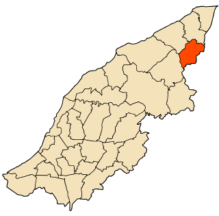
Oued Z'hor is a town and commune in Skikda Province in north-eastern Algeria.

Zerdazas is a town and commune in Skikda Province in north-eastern Algeria.

Bousselam is a town and commune in Sétif Province in north-eastern Algeria.

Bouharoun is a town and commune in Tipaza Province in northern Algeria.

Chaiba is a town and commune in Tipaza Province in northern Algeria.

Khemisti is a town and commune in Tipaza Province in northern Algeria.

Aït Aggouacha is a town and commune in Tizi Ouzou Province in northern Algeria. It is famed for its high quality kebabs.

At Dwala is a town and commune in Tizi Ouzou Province in northern Algeria. At Dwala, or Aït Douala, is located 17 km south-east of Tizi-Ouzou.

M'Kira is a town and commune in Tizi Ouzou Province in northern Algeria.

Lindun Lu station

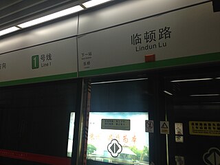
Lindun Lu Station is a station of Line 1, Suzhou Rail Transit. The station is located in Gusu District of Suzhou. It has been in use since April 28, 2012, the same time of the preoperation of Line 1.

Devipur, Deoghar Community development block in Jharkhand, India

Devipur is a community development block that forms an administrative division in Deoghar district, Jharkhand state, India. It is located 22 km from Deoghar, the district headquarters.

References

  1. "Communes of Algeria". Statoids. Retrieved December 12, 2010.

Coordinates: 36°37′37″N6°38′20″E / 36.62694°N 6.63889°E / 36.62694; 6.63889

Geographic coordinate system Coordinate system

A geographic coordinate system is a coordinate system that enables every location on Earth to be specified by a set of numbers, letters or symbols. The coordinates are often chosen such that one of the numbers represents a vertical position and two or three of the numbers represent a horizontal position; alternatively, a geographic position may be expressed in a combined three-dimensional Cartesian vector. A common choice of coordinates is latitude, longitude and elevation. To specify a location on a plane requires a map projection.