This article needs additional citations for verification .(April 2022) |
El Harrouch الحروش | |
---|---|
Commune and town | |
Nickname(s): Meslen el-kebch | |
Coordinates: 36°39′11″N6°50′11″E / 36.65306°N 6.83639°E Coordinates: 36°39′11″N6°50′11″E / 36.65306°N 6.83639°E | |
Country | Algeria |
Province | Skikda Province |
Population (2008) | |
• Total | 33,085 |
Time zone | UTC+1 (CET) |
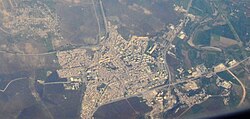
El Harrouch is a town and commune in Skikda Province in north-eastern Algeria. It is located on the main N3 road south of Skikda and north of Constantine. [1]
The town of El Harrouch had a population of about 48,994 people at the 2008 General Census of Population and Housing (GCPH), an area of about 101 km2, with a density of around 485 inhabitants per kilometers squared. and an urbanization rate of 67.7%.
The summer and winter seasons are well defined. Rains are less important in summer than they are in winter. According to the Köppen-Geiger classification, the climate is of the Csa type. The average temperature at El Harrouch is 17.4 °C. It falls on average 704 mm of rain per year.
The driest month is July with only 5 mm. With an average of 126 mm, January recorded the highest precipitation. With an average temperature of 26.0 °C, the month of August is the warmest of the year. With an average temperature of 10.0 °C, the month of January is the coldest of the year.
The town was going to be named "Meslen el-kebch" (spine sheep) but the notable of the city decided to not adopt it, concerning the current name of the city in base it's el arrouche العروش which in some sorts refers to tribes .
Located halfway between the ancient Cirta (Constantine) and the ancient Skikda, the history of El Harrouch remains strongly linked to the two major urban centers. There is however very little information about the area before the Roman occupation, though pre Roman tombstones, shine some light on that period.
When the French troops arrived in El Harrouch, the remains of the Roman road from Stora to Cirta were still visible and usable. It was by following this ribbon of stones that the battalions arrived on the coast. In 1838, the first military detachments settled permanently in El Harrouch where four bastions, ensured the defense of the camp. The first settlers arrived soon after.
Twice the Government had to repopulate this settlement center, the colonists having been decimated by cholera and earthquakes. The settlement of El Harrouch was mainly Belgian and German families. The commune of El Harrouch was created by decree of 28 August 1881.
Ali Kafi Algerian President (1992-1994) was born in the town and Khaled el-Hassani ben el-Hashemi was married there.
Constantine, also spelled Qacentina or Kasantina, is the capital of Constantine Province in northeastern Algeria. During Roman times it was called Cirta and was renamed "Constantina" in honor of emperor Constantine the Great. It was the capital of the French department of Constantine until 1962. Located somewhat inland, Constantine is about 80 kilometres from the Mediterranean coast, on the banks of the Rhumel River.
Moroyama is a town located in Saitama Prefecture, Japan. As of 1 January 2021, the town had an estimated population of 33,178 in 15,888 households and a population density of 970 persons per km². The total area of the town is 34.07 square kilometres (13.15 sq mi).
Touggourt is a city and commune, former sultanate and capital of Touggourt District, in Touggourt Province, Algeria, built next to an oasis in the Sahara. As of the 2008 census, the commune had a population of 39,409 people, up from 32,940 in 1998, and an annual growth rate of 1.8%. Touggourt's urban area includes the communes of Nezla, Tebesbest and Zaouia El Abidia, for a total population of 146,108.
Skikda is a city in northeastern Algeria and a port on the Mediterranean. It is the capital of Skikda Province and Skikda District.
Cirta, also known by various other names in antiquity, was the ancient Berber and Roman settlement which later became Constantine, Algeria.
Biskra is the capital city of Biskra Province, Algeria. In 2007, its population was recorded as 307,987. Biskra is located in northeastern Algeria, about 248 miles (400 km) from Algiers, 71 miles (115 km) southwest of Batna and 137 miles (222 km) north of Touggourt. It is nicknamed "The Queen of the Zibans", "The Door of the Desert" or "The Saharan Nice" because of its location at the beginning of the Sahara Desert. Due to its geographical location, its climate and natural resources, particularly farming, Biskra has always been a hub and a crossroad between the cities in the north and south. It has seen the passage of several civilizations, from the Romans and the Arabs to the French.
Adrar is the administrative capital of Adrar Province, the second largest province in Algeria. The commune is sited around an oasis in the Touat region of the Sahara Desert. According to a 2008 census it has a population of 64,781, up from 43,903 in 1998, with an annual growth rate of 4.0%.
Ouargla is the capital city of Ouargla Province in the Sahara Desert in southern Algeria. It has a flourishing petroleum industry and hosts one of Algeria's universities, the University of Ouargla. The commune of Ouargla had a population of 133,024 in the 2008 census, up from 112,339 in 1998, and an annual population growth rate of 1.7%. However, including the commune of Rouissat, found in Ouargla's urban area, gives a total population of 191,136.
Guelma is the capital of Guelma Province and Guelma District, located in north-eastern Algeria, about 65 kilometers from the Mediterranean coast. Its location corresponds to that of ancient Calama.
Tindouf is the main town, and a commune in Tindouf Province, Algeria, close to the Mauritanian, Western Saharan and Moroccan borders. The commune has population of around 160,000 but the census and population estimates do not count the Sahrawi refugees making the population as of the 2008 census 45,966, up from 25,266 in 1998, and an annual population growth rate of 6.3%.
Radoviš is a city in the southeastern part of North Macedonia. It is the second largest city in the southeastern region. The city is the seat of Radoviš Municipality, which is spread on the bottom of Plačkovica Mountain and the northern part of the Radoviš-Strumica valley. The main road M6 Štip–Radoviš-Strumica is tangentially placed on the township of Radoviš. This road is a main communication route with other parts of the country.
Bordj Omar Driss is a town and commune in In Amenas District, Illizi Province, Algeria. According to the 2008 census it has a population of 5,736, up from 3,547 in 1998, and an annual population growth rate of 5.0%. Its postal code is 33210 and its municipal code is 3304.
Ighram is a town and commune of Kabylie in northern Algeria. The town is located on the Soummam, on its left bank. It is located south-west of the wilaya of Bejaia, a distance of more than 70 km from the provincial capital and less than 5 km from Akbou. It covers an area of 50.11 square kilometers and the population of the town of Ighram is estimated at 16 878 inhabitants, 8 472 men and 8 406 women with a density of 332 inhabitants / km ².
Héliopolis, Algeria is a town and commune in Guelma Province, Algeria. According to the 1998 census it has a population of 22,605.
El Milia ( الميلية) is a town and commune in Jijel Province, Algeria.
Igilgili was a Berber town and a Phoenician, Carthaginian, and Roman colony in located in present-day Jijel, Algeria.
Tiddis was a Roman city that depended on Cirta and a bishopric as "Tiddi", which remains a Latin Catholic titular see.
El-Kentour (الكنتور) is a town and mountain in Algeria. It is located in the Constantine Mountains. El-Kentour is also the site of the El-Ouahch to El-Kentour tunnel, which is part of the National Road 3.
Boughalboune is a town in Skikda Province, Algeria. The town is on the N3 highway to Skikda and sits on the bank of a tributary of the Oued Ensa River. The topography of the town is mountainous.
Numidia was a Roman province on the North African coast, comprising roughly the territory of north-east Algeria.