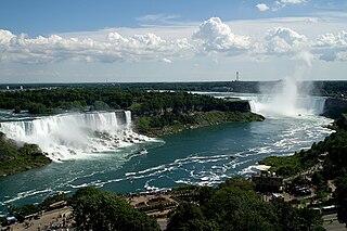
Niagara Falls is the collective name for three waterfalls that straddle the international border between the Canadian province of Ontario and the US state of New York. They form the southern end of the Niagara Gorge.

A waterfall is an area where water flows over a vertical drop or a series of steep drops in the course of a stream or river. Waterfalls also occur where meltwater drops over the edge of a tabular iceberg or ice shelf.
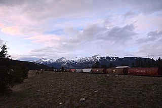
Jasper National Park is the largest national park in the Canadian Rockies, spanning 11,000 km2 (4,200 sq mi). It is located in the province of Alberta, north of Banff National Park and west of Edmonton. The park includes the glaciers of the Columbia Icefield, hot springs, lakes, waterfalls and mountains.

Angel Falls is a waterfall in Venezuela. It is the world's highest uninterrupted waterfall, with a height of 979 metres (3,212 ft) and a plunge of 807 m (2,648 ft). The waterfall drops over the edge of the Auyán-tepui mountain in the Canaima National Park, a UNESCO World Heritage site in the Gran Sabana region of Bolívar State. The height figure, 979 m (3,212 ft), mostly consists of the main plunge but also includes about 400 metres (1,300 ft) of sloped cascade and rapids below the drop and a 30-metre (98 ft) high plunge downstream of the talus rapids.

The Snoqualmie River is a 45-mile (72 km) long river in King County and Snohomish County in the U.S. state of Washington. The river's three main tributaries are the North, Middle, and South Forks, which drain the west side of the Cascade Mountains near the town of North Bend and join near the town of Snoqualmie just above the Snoqualmie Falls. After the falls the river flows north through rich farmland and the towns of Fall City, Carnation, and Duvall before meeting the Skykomish River to form the Snohomish River near Monroe. The Snohomish River empties into Puget Sound at Everett. Other tributaries of the Snoqualmie River include the Taylor River and the Pratt River, both of which enter the Middle Fork, the Tolt River, which joins at Carnation, and the Raging River at Fall City.

Pictured Rocks National Lakeshore is a U.S. National Lakeshore on the shore of Lake Superior in the Upper Peninsula of Michigan, United States. It extends for 42 miles (67 km) along the shore and covers 73,236 acres. The park has extensive views of the hilly shoreline between Munising and Grand Marais in Alger County, Michigan, with picturesque rock formations, waterfalls, and sand dunes.

Aira Force is a waterfall in the English Lake District, in the civil parish of Matterdale and the county of Cumbria. The site of the waterfall is owned by the National Trust.
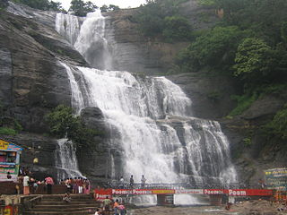
Courtallam or Kuttalam, Spa of South India, is a panchayat town situated at a mean elevation of 160 m (520 ft) on the Western Ghats in Tirunelveli District of Tamil Nadu, India. Many seasonal and few perennial rivers such as the Chittar River, the Manimuthar River, the Pachaiyar River and the Thamirabarani River originate in this region. The numerous waterfalls and cascades along with the ubiquitous health resorts in the area have earned it the title the Spa of South India. The falls carry a good amount of water only when there is a rain on the hills. The season begins from June of every year till September. The South West Monsoon brings in the cold breeze with mild temperature. From October to December North East Monsoon sets over in Tamil Nadu and the climate is cold and the rains are very heavy sometimes. Sometimes the falls get flooded and people are not allowed to take bath during floods.
The Black River is a 41.1-mile-long (66.1 km) river on the Upper Peninsula of the U.S. state of Michigan, flowing mostly in Gogebic County into Lake Superior at 46°40′03″N90°02′57″W. Its source at 46°18′54″N90°01′15″W is a boreal wetland on the border with Iron County, Wisconsin. The northern section of the river, 14 miles (23 km) within the boundaries of the Ottawa National Forest, was designated a National Wild and Scenic River in 1992.

The Tinaroo Falls, a waterfall on the Barron River, is located in the below the Lake Tinaroo dam wall in Far North region of Queensland, Australia.

There are 24 named waterfalls in Ricketts Glen State Park in the U.S. state of Pennsylvania along Kitchen Creek as it flows in three steep, narrow valleys, or glens. They range in height from 9 feet (2.7 m) to the 94-foot (29 m) Ganoga Falls. Ricketts Glen State Park is named for R. Bruce Ricketts, a colonel in the American Civil War who owned over 80,000 acres (32,000 ha) in the area in the late 19th and early 20th centuries, but spared the old-growth forests in the glens from clearcutting. The park, which opened in 1944, is administered by the Bureau of State Parks of the Pennsylvania Department of Conservation and Natural Resources (DCNR). Nearly all of the waterfalls are visible from the Falls Trail, which Ricketts had built from 1889 to 1893 and which the state park rebuilt in the 1940s and late 1990s. The Falls Trail has been called "the most magnificent hike in the state" and one of "the top hikes in the East".
Bacon Creek is a glacial stream in Whatcom County, Washington. It originates in a glacier on the southwest face of Bacon Peak, flows into a small tarn, then flows over the Berdeen Falls. At the base of the waterfall, the creek turns southeast and joins the Skagit River near and discharges into the Skagit River near Marblemount.

The Ministry of Tourism of Ghana is the government ministry responsible for the development and promotion of tourism-related activities in the country.

Charpa Falls is a waterfall located in Athirappilly panchayath in Thrissur district of Kerala. Located on the west-flowing Chalakudy River, this waterfall lies in between the more famous Athirappilly Falls and Vazhachal Falls. It is a popular stopover for tourists who are visiting the Athirappilly and Vazhachal Falls. It is located close to the road, and during monsoon months, the water splashes onto the road. During the dry season, the water stops flowing.
Green Lake is located in North Cascades National Park, in the U. S. state of Washington. Situated 1.5 mi (2.4 km) northeast of Bacon Peak, Green Lake receives some runoff from Green Lake Glacier which empties into the lake after plunging 375 ft (114 m) over Bacon Lake Falls. Another series of waterfalls lie below Green Lake and are known as Green Lake Falls which drop another 979 ft (298 m).
Blum Lakes are located in North Cascades National Park, in the U. S. state of Washington. Consisting of approximately six cirque lakes immediately southwest of Mount Blum, the Blum Lakes are not near any maintained trails. Outflow from the lakes feeds into a tributary of Blum Creek. Nearby the Blum Basin Falls plunges 1,680 ft (510 m) along another tributary of Blum Creek.

A subterranean waterfall or underground waterfall is a waterfall located underground, usually in a cave or mine. They are a common feature in cave systems where there are vertical or near vertical geological structures for the weathering process to exploit, and sufficient gradient between the sink and the rising. The highest known subterranean waterfall is in Vrtoglavica Cave in Slovenia, and is at least 400 metres (1,300 ft). A renowned example in the United States is Ruby Falls, 44 metres (144 ft) high, in Lookout Mountain Caverns, a show cave in Tennessee.

