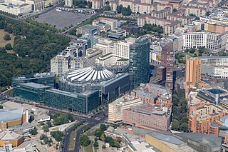
Potsdamer Platz is a public square and traffic intersection in the center of Berlin, Germany, lying about 1 km (1,100 yd) south of the Brandenburg Gate and the Reichstag, and close to the southeast corner of the Tiergarten park. It is named after the city of Potsdam, some 25 km (16 mi) to the south west, and marks the point where the old road from Potsdam passed through the city wall of Berlin at the Potsdam Gate. Initially, the open area near the city gate was used for military drills and parades. In the 19th into the 20th century, it developed from an intersection of suburban thoroughfares into the most bustling traffic intersection in Europe. The area was totally destroyed during World War II and then left desolate during the Cold War era when the Berlin Wall bisected its location. Since German reunification, Potsdamer Platz has been the site of major redevelopment projects.

U1 is a line on the Berlin U-Bahn, which is 8.8 kilometres (5.5 mi) long and has 13 stations. Its traditional line designation was BII. It runs east–west and its eastern terminus is Warschauer Straße S-Bahn station where it connects to the Schlesische Bahn. From there it runs through Kreuzberg via Gleisdreieck and Wittenbergplatz on to the Kurfürstendamm.

U2 is a line of the Berlin U-Bahn. The U2 line starts at Pankow S-Bahn station, runs through the eastern city centre (Alexanderplatz) to Potsdamer Platz, the western city centre and finally to the Ruhleben terminal station.

U3 is a line on the Berlin U-Bahn created in its current version on 7 May 2018.

Schöneberg is a locality of Berlin, Germany. Until Berlin's 2001 administrative reform it was a separate borough including the locality of Friedenau. Together with the former borough of Tempelhof it is now part of the new borough of Tempelhof-Schöneberg.
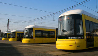
The Berlin tramway is the main tram system in Berlin, Germany. It is one of the oldest tram networks in the world having its origins in 1865 and is operated by Berliner Verkehrsbetriebe (BVG), which was founded in 1929. It is notable for being the third-largest tram system in the world, after Melbourne and St. Petersburg. Berlin's tram system is made up of 22 lines that operate across a standard gauge network, with almost 800 stops and measuring almost 190 kilometres (120 mi) in route length and 430 kilometres (270 mi) in line length. Nine of the lines, called Metrotram, operate 24 hours a day and are identified with the letter "M" before their number; the other thirteen lines are regular city tram lines and are identified by just a line number.

The Potsdamer Bahnhof is a former railway terminus in Berlin, Germany. It was the first railway station in Berlin, opening in 1838. It was located at Potsdamer Platz, about 1 km south of the Brandenburg Gate, and kick-started the transformation of Potsdamer Platz from an area of quiet villas near the south-east corner of the Tiergarten park into the bustling focal point that it eventually became. For more than a century it was the terminus for long-distance and suburban trains. Also located at this spot were underground stations on the Berlin U-Bahn and S-Bahn, and today's new underground Regionalbahnhof, known as Bahnhof Potsdamer Platz, while the short-lived M-Bahn crossed the site of the former terminus.

Mohrenstraße is a Berlin U-Bahn station on line U2, located in the district of Mitte.

Ebertstraße is a street in Berlin, the capital of Germany. It runs on a roughly north-south line from the Brandenburg Gate to Potsdamer Platz in the centre of the city.

Leipziger Straße is a major thoroughfare in the central Mitte district of Berlin, capital of Germany. It runs from Leipziger Platz, an octagonal square adjacent to Potsdamer Platz in the west, to Spittelmarkt in the east. Part of the Bundesstraße 1 highway, it is today one of the city's main east–west road links.

Tiergartenstraße is a street in the Tiergarten district in central Berlin, the capital of Germany. The street runs east-west along the southern edge of the Großer Tiergarten park from Kemperplatz and Ben-Gurion-Straße near Sony Center and Potsdamer Platz in the east to the intersection of Hofjägerallee and Klingelhöferstraße in the west. On the street’s southern side, the street intersects with, Herbert-von-Karajan-Straße, Stauffenbergstraße, Hildebrandstraße, Hiroshimastraße and Clara-Wieck-Straße.

Stralauer Tor was a Berlin U-Bahn station in Berlin-Friedrichshain. It operated between Warschauer Straße and Schlesisches Tor stations on today's U1. Following its destruction in World War II it was never rebuilt and is one of three Berlin U-Bahn stations to have been abandoned after having previously been in service.

Berlin Potsdamer Platz is a railway station in Berlin. It is completely underground and situated under Potsdamer Platz in central Berlin. Regional and S-Bahn services call at the station, and it is also served by U-Bahn line U2.

Seedorf is a municipality in the district of Segeberg, in Schleswig-Holstein, Germany.

Mitte is a central section of Berlin, Germany, in the eponymous borough of Mitte. Until 2001, it was itself an autonomous district.

The North–South S-Bahn Tunnel is the central section of the North–South transversal Berlin S-Bahn connection crossing the city centre. It is not to be confused with the Tunnel Nord-Süd-Fernbahn, the central tunnel part of the North–South main line used by intercity and regional trains. The S-Bahn North–South line encompasses the route from Bornholmer Straße and Gesundbrunnen via Friedrichstraße and Anhalter Bahnhof to Papestraße and Schöneberg.

The Berlin Customs Wall was a ring wall around the historic city of Berlin, between 1737 and 1860; the wall itself had no defence function but was used to facilitate the levying of taxes on the import and export of goods (tariffs) which was the primary income of many cities at the time.

The unbuilt U10 line, of the Berlin U-Bahn, was part of a planned "200-km-plan" extension of the Berlin U-Bahn from 1953–55. It would have been a large-profile (Großprofil) metro line running from Falkenberg, in the northeastern part of the city, to Alexanderplatz, and down to Steglitz before terminating at Drakestraße in Lichterfelde. The designated letter name of the line was "F" until 1 July 1972, when it was changed to "Line 10". Because a number of tunnels and stations were constructed to accommodate the proposed line with elements visible at transfer stations and elsewhere, the line is popularly known as the "Phantomlinie".

The Berlin U-Bahn originated in 1880 with Werner Siemens' idea to build an urban railway in Berlin. During the nine years after the German Empire was founded, the city's population grew by over one-third and traffic problems increased. In 1896, Siemens & Halske began to construct the first stretch of overhead railway. On 1 April 1897, the company began construction of an electric underground railway. The Berliner Verkehrs Aktiengesellschaft (BVG) was formed in 1928, and took over further construction and operation of the network. In 1938, the company was renamed Berlin Transport Company; the original acronym, however, remained. Since 1994, the BVG has been a public company.

The IGA Cable Car, also known as Berlin Cableway, IGA Ropeway or IGA Cableway, is a 1.58 km (0.98 mi)-long gondola lift line serving and crossing the Erholungspark Marzahn in Berlin, capital of Germany. Built for the Internationale Gartenausstellung 2017, an international horticultural exhibition, it is the first cableway opened in the German capital.