During the navigation improvements of 1803–1811, a new lock cut was made to bypass a large meandering loop of the River Hull around Struncheon Hill. Mr Richard Bethell, who owned the Leven Canal, also owned the land around this cutting, and needed a bridge to access his land.
William Chapman, who carried out the works, decided on a swing bridge, as was in common use in the rest of the navigation, but since the cut was made wide to accommodate the flow of the river, a fixed section was used to reduce the size of the opening section.
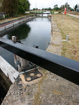
One of the original cast iron wheels before removal
A brick base, with a cast iron curved edge strip, was built. It rested on a cast iron pintel, with four wheels to steady the structure, which rested on a curved iron track. The main structure of the bridge was built from wood (probably oak), with steel bracing to hold the structure together. The hand rails were also built from wood, and had crisscross stays.
At the same time, a bridge-keepers house was built, presently known as Swing Bridge Cottage. When the traffic dropped on the Driffield Navigation, the bridge keeper was no longer needed and the house was left empty. In the early 1970s Colin Askin occupied the property, and restored and improved the house, raising his family there.
Without regular maintenance, the bridge started to deteriorate in the 1950s. The wood warped, and became inoperable some time in the late 1960s.
In 1978, on a cold December night, a large lorry crossed the bridge, and made it unsafe. As this bridge was a vital link for the milk lorry which served the farms, and also a short cut for other farm traffic the local farmers - Richard Southwell from Rotsea Carr farm, Mike and Ben Southwell from Hunts Hill farm (all brothers), and Mr Keith Conner from Struncheon Hill farm, along with Colin Askin and other members of the Driffield Navigation Amenities Association helped replace, and repair the structure.
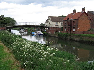
Around that time, Bethells Bridge Boat Club was also founded, and had their first AGM in 1979. The BBBC used Ben Southwell's land along the bank above the bridge for moorings. In later years, other farmers started letting out moorings on their banks, so there are now many boats moored in the area.
Looking across the bridge from the east bank
Further work was carried out on the structure by the DNAA in the early 1980s to improve the brickwork and structure of the bridge foundation. Further work was carried out on the fixed portion of the bridge in the later part of the 1980s, which replaced the handrails, and many of the bridge floor beams which were going rotten.
Driffield Navigation Trust, the current managers of the navigation decided that they had a claim on Swing Bridge Cottage. Colin Askin, who still lived there, could have claimed squatters rights, but since he believed in the restoration of the navigation moved out. It was being let to generate funds, but in 2017 was sold to private ownership.
The new bridge is lifted into place
During the late 1990s the wooden fixed section was in need of attention. It was replaced with a steel structure, but kept the wooden decking.
In 2001?, a new steel bridge was built for Brigham Bridge. Unfortunately this was too small for the traffic that needed to go over it, and it sat in the construction yard for the next few years. In March 2003 this bridge was used to replace the complete structure, with a new fixed section decking made from steel, installed by Simpsons Civil Engineering of Driffield.
Access to the bridge for boaters became a problem after the bridge keeper was no more. There were no bridge moorings below or above the bridge, and often crew would need to be let off on the bridge base. In 2006 a landing stage was constructed by DNAA above the bridge to make it easier to operate.
The shaded waters of the bridge also attract shoals of perch and pike.
The River Thurne is a river in Norfolk, England in The Broads. Just 7 miles (11 km) long, it rises 2 miles (3.2 km) from the coast near Martham Broad and is navigable from West Somerton. It flows southwest and is linked by Candle Dyke and Heigham Sound to both Horsey Mere and Hickling Broad. It continues southwest and flows through Potter Heigham and enters the River Bure just south of Thurne dyke, near St Benet's Abbey.
The River Hull is a navigable river in the East Riding of Yorkshire in Northern England. It rises from a series of springs to the west of Driffield, and enters the Humber Estuary at Kingston upon Hull. Following a period when the Archbishops of York charged tolls for its use, it became a free navigation. The upper reaches became part of the Driffield Navigation from 1770, after which they were again subject to tolls, and the section within the city of Hull came under the jurisdiction of the Port of Hull, with the same result.
The Caledonian Canal connects the Scottish east coast at Inverness with the west coast at Corpach near Fort William in Scotland. The canal was constructed in the early nineteenth century by Scottish engineer Thomas Telford.
The River Weaver is a river, navigable in its lower reaches, running in a curving route anti-clockwise across west Cheshire, northern England. Improvements to the river to make it navigable were authorised in 1720 and the work, which included eleven locks, was completed in 1732. An unusual clause in the enabling Act of Parliament stipulated that profits should be given to the County of Cheshire for the improvement of roads and bridges, but the navigation was not initially profitable, and it was 1775 before the first payments were made. Trade continued to rise, and by 1845, over £500,000 had been given to the county.
A swing bridge is a movable bridge that has as its primary structural support a vertical locating pin and support ring, usually at or near to its center of gravity, about which the swing span can then pivot horizontally as shown in the animated illustration to the right. Small swing bridges as found over canals may be pivoted only at one end, opening as would a gate, but require substantial underground structure to support the pivot.
The Wey and Arun Canal is a partially open, 23-mile-long (37 km) canal in the southeast of England. It runs southwards from the River Wey at Gunsmouth in Shalford, Surrey to the River Arun at Pallingham, in West Sussex. The canal comprises parts of two separate undertakings – the northern part of the Arun Navigation, opened in 1787 between Pallingham and Newbridge Wharf, and the Wey and Arun Junction Canal, opened in 1816, which connected the Arun at Newbridge to the Godalming Navigation near Shalford, south of Guildford. The Arun Navigation was built with three locks and one turf-sided flood lock. The Junction Canal was built with 23 locks
The English River Thames is navigable from Cricklade or Lechlade to the sea, and this part of the river falls 71 meters (234 feet). There are 45 locks on the river, each with one or more adjacent weirs. These lock and weir combinations are used for controlling the flow of water down the river, most notably when there is a risk of flooding, and provide for navigation above the tideway.
The Blyth Navigation was a canal in Suffolk, England, running 7 miles (11 km) from Halesworth to the North Sea at Southwold. It opened in 1761, and was insolvent by 1884. Its demise was accelerated by an attempt to reclaim saltings at Blythburgh, which resulted in the estuary silting up. It was used sporadically until 1911, and was not formally abandoned until 1934.
Caversham Lock is a lock and main weir on the River Thames in England at Reading, Berkshire. Both the lock and main weir are connected to De Bohun Island. The Thames Navigation Commissioners built the original lock in 1778. Additional sluices north of View Island and Heron Island form the whole weir complex. A footbridge passes over all three islands to connect Lower Caversham to Reading via a route other than George Street and Reading Bridge.
The Leven Canal runs for 3.18 miles (5.1 km) from the River Hull to the village of Leven, East Riding of Yorkshire, England. It was built for Mrs Charlotta Bethell in 1805, and remained in use until 1935. It is now a Site of Special Scientific Interest.
The Driffield Navigation is an 11-mile (18-kilometre) waterway, through the heart of the Holderness Plain to the market town of Driffield, East Riding of Yorkshire, England. The northern section of it is a canal, and the southern section is part of the River Hull. Construction was authorised in 1767, and it was fully open in 1770. Early use of the navigation was hampered by a small bridge at Hull Bridge, which was maintained by Beverley Corporation. After protracted negotiation, it was finally replaced in 1804, and a new lock was built to improve water levels at the same time. One curious feature of the new works were that they were managed quite separately for many years, with the original navigation called the Old Navigation, and the new works called the New Navigation. They were not fully amalgamated until 1888.
Hambleden Lock is a lock with a long weir situated on the River Thames in England, about 2 miles downstream of Henley Bridge. The lock is on the Berkshire bank between Aston and Remenham. Built by the Thames Navigation Commission in 1773, the lock is named after the village of Hambleden, a mile (1.5 km) to the north.
Struncheon Hill Lock was built as a later addition to the Driffield Navigation in the East Riding of Yorkshire, England. It improved access to the next section of water during low tide conditions where the navigation meets the tidal River Hull. It is sometimes known as "Top Hill Low", which is the name of the large pumping station located there.
Emmotland is a small hamlet in the East Riding of Yorkshire, England. It forms part of the civil parish of North Frodingham.
Brigham is a small village in the East Riding of Yorkshire, England. It is situated approximately 4 miles (6 km) south-east from Driffield, 15 miles (24 km) north of Hull city centre, and to the west of the B1249 road. The village forms part of the civil parish of Foston on the Wolds.
Snakeholme Lock is a brick chamber canal lock on the Driffield Navigation, in the East Riding of Yorkshire, England. It is notable in being a staircase lock, but only the upper lock is still used. It was designated Grade II in 1986.
The Stainforth and Keadby Canal is a navigable canal in South Yorkshire and Lincolnshire, England. It connects the River Don Navigation at Bramwith to the River Trent at Keadby, by way of Stainforth, Thorne and Ealand, near Crowle. It opened in 1802, passed into the control of the River Don Navigation in 1849, and within a year was controlled by the first of several railway companies. It became part of the Sheffield and South Yorkshire Navigation, an attempt to remove several canals from railway control, in 1895. There were plans to upgrade it to take larger barges and to improve the port facilities at Keadby, but the completion of the New Junction Canal in 1905 made this unnecessary, as Goole could easily be reached and was already a thriving port.
Hull Bridge is a village in the East Riding of Yorkshire, England. It is situated approximately 1.5 miles (2.4 km) north-east of Beverley town centre. It lies south of the A1035 road and straddles the Beverley and Barmston Drain and the River Hull from which it takes its name.
Trowse Bridge is a single-track railway bridge which carries the Great Eastern Main Line over the River Wensum just outside Norwich in England at grid reference TG245076.
The bridge at New Bridge Landing, New Jersey was built in 1888 to replace an earlier wooden one, and was added to the National Register of Historic Places on July 5, 1989.
This page is based on this Wikipedia article Text is available under the CC BY-SA 4.0 license; additional terms may apply. Images, videos and audio are available under their respective licenses.