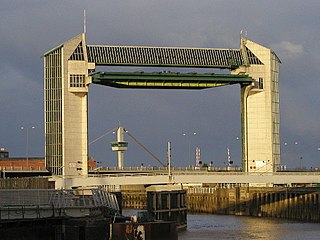
The River Hull is a navigable river in the East Riding of Yorkshire in Northern England. It rises from a series of springs to the west of Driffield, and enters the Humber Estuary at Kingston upon Hull. Following a period when the Archbishops of York charged tolls for its use, it became a free navigation. The upper reaches became part of the Driffield Navigation from 1770, after which they were again subject to tolls, and the section within the city of Hull came under the jurisdiction of the Port of Hull, with the same result.

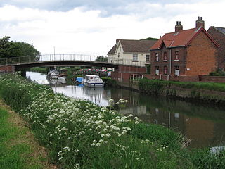
The Driffield Navigation is an 11-mile (18-kilometre) waterway, through the heart of the Holderness Plain to the market town of Driffield, East Riding of Yorkshire, England. The northern section of it is a canal, and the southern section is part of the River Hull. Construction was authorised in 1767, and it was fully open in 1770. Early use of the navigation was hampered by a small bridge at Hull Bridge, which was maintained by Beverley Corporation. After protracted negotiation, it was finally replaced in 1804, and a new lock was built to improve water levels at the same time. One curious feature of the new works were that they were managed quite separately for many years, with the original navigation called the Old Navigation, and the new works called the New Navigation. They were not fully amalgamated until 1888.

Kilham is a village and civil parish in the East Riding of Yorkshire, England. It is situated about 5 miles (8 km) north-east of Driffield town centre. According to the 2011 UK census, Kilham parish had a population of 1,088, an increase on the 2001 UK census figure of 1,010.

Garton on the Wolds is a village and civil parish on the Yorkshire Wolds in the East Riding of Yorkshire, England. It is situated approximately 3 miles (5 km) north-west of Driffield town centre and lies on the A166 road.

Brandesburton is a village and civil parish in the East Riding of Yorkshire, England. It is situated approximately 7 miles (11 km) west of Hornsea and 9 miles (14 km) north-east of the market town of Beverley.

Aike Beck or the Lockington Navigation was a stream in the East Riding of Yorkshire, England, which was constructed as a navigation in the late 18th century, and ceased to function as such in the 1850s. The water supply came from Bryan Mills Beck and Scorborough Beck, but in 1988, these were diverted to feed into Arram Beck, and most of the channel was filled in with material from the flood banks.

West Beck is the common name given to the upper section of the old River Hull, as it rises in the foothills of the Yorkshire Wolds. After reaching Frodingham Beck at Emmotland, it becomes called the River Hull. It is noteworthy for being the most northerly chalk stream in England. It provides fly fishing for wild brown trout and grayling.

Fisholme is a small area in the East Riding of Yorkshire, England that is situated between Brigham and Emmotland. The canal section of the Driffield Navigation leaves Frodingham Beck at this point.
Brigham is a small village in the East Riding of Yorkshire, England. It is situated approximately 4 miles (6 km) south-east from Driffield, 15 miles (24 km) north of Hull city centre, and to the west of the B1249 road. The village forms part of the civil parish of Foston on the Wolds.

Gembling is a hamlet in the civil parish of Foston on the Wolds in the East Riding of Yorkshire, England. It is situated approximately 8 miles (13 km) south-west from the coastal resort of Bridlington and 2.5 miles (4 km) north from the village of North Frodingham.
Wilfholme is a hamlet in the East Riding of Yorkshire, England. It forms part of the civil parish of Beswick, and is situated just east from the A164 road, approximately 5 miles (8 km) north from Beverley and 6 miles (10 km) south from Driffield. Wilfholme Landing is 0.9 miles (1.4 km) to the south-east and provides access to the Driffield Navigation.
Wansford is a village in the East Riding of Yorkshire, England; it forms part of the civil parish of Skerne and Wansford. It is situated on the B1249 road and just to the north of the River Hull and the Driffield Canal. It is approximately 2.5 miles (4 km) south-east of Driffield and 3 miles (4.8 km) north-west of North Frodingham.
Rotsea is a hamlet in the East Riding of Yorkshire, England. It is situated approximately 4.5 miles (7.2 km) south-east of Driffield and 2.5 miles (4 km) south-west of North Frodingham.
North Frodingham is a village and civil parish in the East Riding of Yorkshire, England. It is situated approximately 5.5 miles (9 km) south-east of the town of Driffield and lies on the B1249 road.
Kirby Underdale is a village and civil parish in the East Riding of Yorkshire, England. It is situated approximately 6 miles (10 km) north of Pocklington town centre and lies 1 mile (1.6 km) north of the main A166 road from York to Driffield.
Eastburn is a hamlet in the East Riding of Yorkshire, England, it forms part of the civil parish of Kirkburn. It is situated in the Yorkshire Wolds on the A164 road, approximately 2.5 miles (4 km) south-west of Driffield town centre and 3 miles (5 km) north-west of the village of Hutton Cranswick.
Hull Bridge is a village in the East Riding of Yorkshire, England. It is situated approximately 1.5 miles (2.4 km) north-east of Beverley town centre. It lies south of the A1035 road and straddles the Beverley and Barmston Drain and the River Hull from which it takes its name.
Hempholme is a hamlet in the East Riding of Yorkshire, England, in an area known as Holderness. It is situated approximately 8 miles (13 km) north-east of Beverley town centre, and 1 mile (1.6 km) east of the Driffield Navigation.

Foston on the Wolds is a village and civil parish in the East Riding of Yorkshire, England. It is situated approximately 8 miles (13 km) south-west of Bridlington town centre and 2 miles (3 km) north of the village of North Frodingham.
Fimber is a village and civil parish in the East Riding of Yorkshire, England. It is situated approximately 8 miles (13 km) north-west of Driffield town centre and 3 miles (5 km) south-west of the village of Sledmere. It lies on the B1248 road. The civil parish is formed by the village of Fimber and the hamlet of Towthorpe. According to the 2001 UK Census, Fimber parish had a population of 91.

