Related Research Articles

Gerardus Mercator was a geographer, cosmographer and cartographer from the Habsburg Netherlands. He is most renowned for creating the 1569 world map based on a new projection which represented sailing courses of constant bearing as straight lines—an innovation that is still employed in nautical charts.

Willem Janszoon Blaeu, also abbreviated to Willem Jansz. Blaeu, was a Dutch cartographer, atlas maker, and publisher. Along with his son Johannes Blaeu, Willem is considered one of the notable figures of the Netherlandish or Dutch school of cartography during its golden age in the 16th and 17th centuries.

Albertus or Albert Seba was a Dutch pharmacist, zoologist, and collector. Seba accumulated one of the largest cabinets of curiosities in the Netherlands during his time. He sold one of his cabinets in 1717 to Peter the Great of Russia. His later collections were auctioned after his death. He published descriptions of his collections in a lavishly illustrated 4 volume Thesaurus. His early work on taxonomy and natural history influenced Linnaeus.

Leiden University Libraries is a library founded in 1575 in Leiden, Netherlands. It is regarded as a significant place in the development of European culture: it is a part of a small number of cultural centres that gave direction to the development and spread of knowledge during the Enlightenment. This was due particularly to the simultaneous presence of a unique collection of exceptional sources and scholars. Holdings include approximately 5,200,000 volumes, 1,000,000 e-books, 70,000 e-journals, 2,000 current paper journals, 60,000 Oriental and Western manuscripts, 500,000 letters, 100,000 maps, 100,000 prints, 12,000 drawings, 300,000 photographs and 3,000 cuneiform tablets. The library manages the largest collections worldwide on Indonesia and the Caribbean. Furthermore, Leiden University Libraries is the only heritage organization in The Netherlands with five registrations of documents in UNESCO's international Memory of the World Register.

The Royal Library of the Netherlands is the national library of the Netherlands, based in The Hague, founded in 1798.
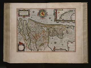
The Atlas Maior is the final version of Joan Blaeu's atlas, published in Amsterdam between 1662 and 1672, in Latin, French, Dutch, German and Spanish, containing 594 maps and around 3,000 pages of text. It was the largest and most expensive book published in the seventeenth century. Earlier, much smaller versions, titled Theatrum Orbis Terrarum, sive, Atlas Novus, were published from 1634 onwards. Like Abraham Ortelius's Theatrum Orbis Terrarum (1570), the Atlas Maior is widely considered a masterpiece of the Golden Age of Dutch/Netherlandish cartography.
The Royal Library of Belgium is the national library of Belgium. The library has a history that goes back to the age of the Dukes of Burgundy. In the second half of the 20th century, a new building was constructed on the Mont des Arts/Kunstberg in central Brussels, near the Central Station. The library owns several collections of historical importance, like the Library of the Dukes of Burgundy, and is the depository for all books ever published in Belgium or abroad by Belgian authors.

Joan Blaeu, also called Johannes Blaeu, was a Dutch cartographer born in Alkmaar, the son of cartographer Willem Blaeu.

The Castello Plan – officially entitled Afbeeldinge van de Stadt Amsterdam in Nieuw Neederlandt – is an early city map of what is now the Financial District of Lower Manhattan from an original of 1660. It was created by Jacques Cortelyou, a surveyor in what was then called New Amsterdam – later renamed by the settlers of the Province of New York settlement as New York City, with its Fort Amsterdam, the center of trade and government. The map that is presently in the New York Public Library is a copy created around 1665 to 1670 by an unknown draughtsman from a lost Cortelyou original.

Frederik de Wit was a Dutch cartographer and artist.

The Klencke Atlas, first published in 1660, is one of the world's largest atlases. Originating in The Netherlands, it is 1.75 metres tall by 1.9 metres wide when open, and so heavy the British Library needed six people to carry it.

Museum Enschedé is a defunct museum that was located in the center of Haarlem, Netherlands, on the Klokhuisplein 5, across from the St. Bavochurch.
Christoffel Beudeker was an Amsterdam merchant and landowner who created an important collection of maps and views of the Dutch Republic and the southern Netherlands which is now in the British Library as the Beudeker Collection.

The Atlas van Loon was commissioned by Frederik Willem van Loon of Amsterdam. It consists of a large number of maps published between 1649 and 1676:

The Maatschappij der Nederlandse Letterkunde is a prestigious and exclusive literary society. The MNL was established in Leiden in 1766 and is still located there. At the moment, the society has approximately 1,600 members, mainly Dutch scholars. New members can only be elected after they are introduced by existing members. The MNL has two regional branches, for the Northern and the Southern part of the Netherlands, and also a representative in South Africa. King Willem-Alexander is the patron of the MNL.

Laurens van der Hem (1621–1678), was a Dutch lawyer and a collector of maps and landscape prints. He is known today for commissioning his meticulously thorough personal version of the Atlas Maior, itself a major work of cartography and art published by his contemporary and friend Joan Blaeu.
Nicolaes Visscher I was a Dutch engraver, cartographer and publisher. He was the son of Claes Janszoon Visscher. His son, Nicolaes Visscher II (1649–1702), also worked with him and continued the family tradition of mapmaking after his death. Visscher died in Amsterdam in 1679 and was buried in the Nieuwezijds Kapel on 11 September of that year, though a death year of 1709 is maintained by some sources.
Frederik Muller or Frits Muller was a Dutch bibliographer, book seller, and print collector. He married Gerarda Jacoba Yntema. Their son Samuel Muller Fz. became known as municipal and state archivist in Utrecht. Another son, Jacob Wijbrand Muller, was to become professor of Dutch language and literature at the University of Utrecht, and his son, Frederik Muller Jzn, would be professor of Latin at the University of Amsterdam and that of Leiden.

The Atlas der Neederlanden, or Atlas of the Netherlands, is a composite atlas which was presumably collected and composed by the publishing company Covens and Mortier in Amsterdam. The maps are gathered in nine volumes and show how the Low Countries, including Belgium and the former colonies of the Netherlands, have developed over the course of about two decades. The atlas contains more than 600 printed and manuscript maps and is preserved by the Special Collections of the University of Amsterdam.
Catchpenny print is the name given to a type of cheap, mass-produced sheets printed on one side and illustrated with simple images, that were sold in the Netherlands in the eighteenth and nineteenth centuries.
References
- 1 2 3 The Beudeker Collection. British Library, 2011. Retrieved 20 July 2011.
- ↑ The Atlas Beudeker. Koninklijke Bibliotheek, 2011. Retrieved 20 July 2011.