Bevere, Belgium

Last updated
Bevere
Village
BevereDorp.JPG
View on Bevere
Belgium location map.svg
Red pog.svg
Bevere
Location in Belgium
Coordinates: 50°51′05″N3°35′39″E / 50.8513°N 3.5943°E / 50.8513; 3.5943
Country Flag of Belgium (civil).svg  Belgium
Region Flemish Region
Province East Flanders
Municipality Oudenaarde
Area
[1]
  Total6.31 km2 (2.44 sq mi)
Population
 (2021) [1]
  Total3,787
  Density600/km2 (1,600/sq mi)
Time zone CET

Bevere is a village in the municipality of Oudenaarde. It is located in the Flemish Ardennes, the hilly southern part of the province of East Flanders, Belgium. In the mid-19th century, it started to form a single urban area with Oudenaarde, but retained some rural parts. [2]

Contents

History

Bevere is situated on the left bank of the Scheldt. The village used to be surrounded by areas which were flooded annually. Settlements from the Early Bronze Age and the Roman era have been discovered near Bevere. The village was first mentioned in 966 as Buerna, and probably means "brook with beavers". The village was an independent heerlijkheid . [2]

Bevere was frequently damaged by war due to its location near the city walls of Oudenaarde. In 1579, the church and many houses were demolished for an extension of the city's fortification. In 1708, the Battle of Oudenarde was partially fought in Bevere. [2]

In 1845, plans were made for the construction of railway lines. At the time, the fortification of Ouenaarde were considered important, and it was decided to build the station in Bevere. In 1856, Oudenaarde railway station  [ nl ] was constructed. The railway lines, and the demolition of the city walls in 1859, resulted in Bevere forming a single urban area with its neighbouring city. [3] [2]

Bevere was an independent municipality until 1965, when it was merged into Oudenaarde. [4]

Buildings and sights

The Vierschaar is a protected monument which served as an open air court of law in the Middle Ages. Jurisdiction originally rested with the Count and Lords, but during the Middle Ages it shifted to the schout and schepenen who held an open air court underneath a tilia tree. Four ropes which laid out, and inside the ropes the trial took place. The original bench for the judges is still present in the field. [5]

The St Peter Church is a three aisled basilica-like church. The foundations of the church are from the Early Middle Ages. The current church was built between 1872 and 1876 in Gothic Revival style. Unlike most churches it is oriented to the south-east. The church was severely damaged in November 1918, and restored between 1921 and 1923. [6]

Notable inhabitants

Related Research Articles

<span class="mw-page-title-main">Welden, Belgium</span> Village in Flemish Region

Welden is a village in the municipality of Oudenaarde in the province of East Flanders, Belgium, and is situated along the Scheldt. It is located about 20 kilometres (12 mi) south of Ghent.

<span class="mw-page-title-main">Opbrakel</span> Village in Flemish Region

Opbrakel is a village and deelgemeente (sub-municipality) of the municipality of Brakel. It is located in the Denderstreek in the province of East Flanders in Belgium. It used to be an independent municipality until 1971 when it was merged into Brakel.

<span class="mw-page-title-main">Parike</span> Village in Flemish Region

Parike is a village and deelgemeente (sub-municipality) of the municipality of Brakel. It is located in the Denderstreek in the province of East Flanders in Belgium. It used to be an independent municipality until 1977 when it was merged into Brakel.

<span class="mw-page-title-main">Eine, Belgium</span> Place in Flemish Region, Belgium

Eine is a village located in the province of East Flanders, Belgium. Since 1965, it has been a deelgemeente (subdivision) of the municipality of Oudenaarde.

<span class="mw-page-title-main">Kerselare</span> Hamlet and pilgrimage site in Flemish Region

Kerselare is a hamlet and pilgrimage site in Edelare, a village belonging to the municipality of Oudenaarde in the province of East Flanders, Belgium. Kerselare is located on the Edelareberg, the highest point of Edelare

<span class="mw-page-title-main">Maarke-Kerkem</span> Village in Flemish Region

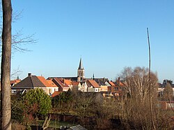
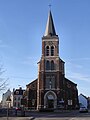
Maarke-Kerkem is a village in the Flemish Ardennes, the hilly southern part of the province of East Flanders, Belgium. It is formed by two hamlets, Maarke and Kerkem, and is incorporated in the municipality of Maarkedal. It is hosting the Saint Vincent Chapel, which was first erected around 1100.

<span class="mw-page-title-main">Oelegem</span> Village in Flemish Region

Oelegem is a village and deelgemeente (sub-municipality) of the municipality of Ranst in the province of Antwerp, Belgium. The village is located about 14 kilometres (8.7 mi) east of the city of Antwerp.

<span class="mw-page-title-main">Zevergem</span> Village in Flemish Region

Zevergem is a village and deelgemeente (sub-municipality) of De Pinte in East Flanders, Belgium. It is located on the Scheldt about 8 kilometres (5.0 mi) south of Ghent.

<span class="mw-page-title-main">Hansbeke</span> Village in East Flanders, Belgium

Hansbeke is a village and deelgemeente (sub-municipality) in the municipality of Deinze in the Belgian province of East Flanders. The village is located about 13 kilometres (8.1 mi) west of Ghent.

<span class="mw-page-title-main">Haasdonk</span> Village in Flemish Region

Haasdonk is a village and deelgemeente (sub-municipality) of Beveren in East Flanders, Belgium. Haasdonk was an independent municipality until 1 January 1977, when it merged with Beveren as part of the fusion of municipalities in Belgium. It is located about 12 kilometres (7.5 mi) west of Antwerp.

<span class="mw-page-title-main">Waarloos</span> Village in Flemish Region

Waarloos is a village and deelgemeente (sub-municipality) of the municipality of Kontich in the province of Antwerp, Belgium. The village is located about 13 kilometres (8.1 mi) south of the city of Antwerp.

<span class="mw-page-title-main">Astene</span> Village in East Flanders, Belgium

Astene is a village and deelgemeente (sub-municipality) in the municipality of Deinze in the Belgian province of East Flanders. The village is located along the Leie River and about 13 kilometres (8.1 mi) south-west of Ghent.

<span class="mw-page-title-main">Sleidinge</span> Village in Flemish Region

Sleidinge is a village in the municipalities of Evergem in the province of East Flanders, Belgium. It is located about 10 kilometres (6.2 mi) north-west of Ghent.

<span class="mw-page-title-main">Kluizen</span> Village in Flemish Region

Kluizen is a village in the municipalities of Evergem and Ghent in the province of East Flanders, Belgium. Large parts of the original municipality have become part of the Port of Ghent.

<span class="mw-page-title-main">Liezele</span> Village in Flemish Region

Liezele is a village and deelgemeente (sub-municipality) of the municipality of Puurs-Sint-Amands in the province of Antwerp, Belgium. The village is located about 20 kilometres (12 mi) south-south-west of the city of Antwerp. On the night of 4 to 5 September 1914, the entire village was destroyed by the Belgian Army to deny the Germany Army cover.

<span class="mw-page-title-main">Viane, Belgium</span> Village in Flemish Region

Viane is a village in the Geraardsbergen municipality of the East Flanders province in the Flemish Community of Belgium. The village is situated in the Denderstreek in the south east of the province, on the border with Flemish Brabant and Hainaut. The river Mark separates the village from the rest of Geraardsbergen.

<span class="mw-page-title-main">Huise</span> Village in East Flanders, Belgium

Huise is a village and deelgemeente (sub-municipality) on a hill within the municipality of Kruisem, part of the province of East Flanders in Belgium.

<span class="mw-page-title-main">Petegem-aan-de-Schelde</span> Village in Flemish Region

Petegem-aan-de-Schelde is a village and former municipality in the Wortegem-Petegem municipality in the Belgian province of East Flanders. The village officially changed its name from Petegem into Petegem-aan-de-Schelde in order to distinguish itself from Petegem-aan-de-Leie. In 1971, the municipality merged into Wortegem-Petegem.

<span class="mw-page-title-main">Wortegem</span> Village in Flemish Region

Wortegem is a village and seat of the municipality of Wortegem-Petegem in the Belgian province of East Flanders. It is located about 17 kilometres (11 mi) east of Kortrijk.

<span class="mw-page-title-main">Tongerlo</span> Village in Flemish Region

Tongerlo is a village and deelgemeente (sub-municipality) of the municipality of Westerlo in the province of Antwerp, Belgium. The village is located about 10 kilometres (6.2 mi) south-east of the city of Herentals. Tongerlo is best known for Tongerlo Abbey founded in 1128 which became one of the most important abbeys of Belgium.

References

  1. 1 2 "Bevolking per statistische sector - Sector 45035A6". Statistics Belgium. Retrieved 6 May 2022.
  2. 1 2 3 4 "Bevere". Agentschap Onroerend Erfgoed (in Dutch). Retrieved 6 May 2022.
  3. "Stations". Le Petit Bruges (in Dutch). Retrieved 6 May 2022.
  4. "Oudenaarde". Agentschap Onroerend Erfgoed (in Dutch). Retrieved 6 May 2022.
  5. "Vierschaar". Elfri Lawyers (in Dutch). Retrieved 6 May 2022.
  6. "Parochiekerk Sint-Petrus". Agentschap Onroerend Erfgoed (in Dutch). Retrieved 6 May 2022.
  7. "Cornelis, Henri". Africa Museum.be (in French). Retrieved 19 June 2022.