Eine, Belgium

Last updated
Eine
Eine - Sint-Eligiuskerk 1.jpg
Saint Eligius church, Eine (2009)
Belgium location map.svg
Red pog.svg
Eine
Coordinates: 50°52′N3°37′E / 50.867°N 3.617°E / 50.867; 3.617 Coordinates: 50°52′N3°37′E / 50.867°N 3.617°E / 50.867; 3.617
Country Belgium
Region Flemish Region
Province East Flanders
Arrondissement Oudenaarde
Municipality Oudenaarde
Area
[1]
  Total8.96 km2 (3.46 sq mi)
Population
 (2021) [1]
  Total5,165
  Density580/km2 (1,500/sq mi)
Area code 055

Eine is a village located in the province of East Flanders, Belgium. Since 1965, it has been a deelgemeente (subdivision) of the municipality of Oudenaarde. [2]

Contents

Overview

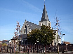
The village lies in the Flemish Ardennes, on the left bank of the Scheldt; the Marollebeek goes through the village. Eine borders Bevere to the centre of Oudenaarde. Saint Eligius is the patron saint of the village. Eine was part of the Diocese of Tournai in the 7th century. [3]

Eine was originally a headland on the Scheldt. In the Middle Ages, it was transformed in an area shaped like an 8 and surrounded by a canal. A castle was built on the small circle and a church on the large circle which is still slightly visible. In 1708, the Battle of Oudenarde was partially fought in Eine. In 1857, the railway line from Oudenaarde to Ghent was built, and the village started to industrialise. Eine was severely damaged in 1918. During the 20th century, it started to become part of the urban area of Oudenaarde. [3]

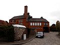
The central cemetery, the recycling center, and the water treatment plant of Oudenaarde are located in Eine. There is also a brewery, Brouwerij Cnudde.

Related Research Articles

<span class="mw-page-title-main">Hemiksem</span> Municipality in Flemish Community, Belgium

Hemiksem is a municipality located in the Belgian province of Antwerp. The municipality only comprises the town of Hemiksem proper. In 2021, Hemiksem had a total population of 11,722. The total area is 5.44 km².

<span class="mw-page-title-main">Weert, Antwerp</span> Village in Flemish Region

Weert is a village in the municipality of Bornem, Antwerp Province, Belgium.

<span class="mw-page-title-main">Nederbrakel</span> Town in Flemish Region

Nederbrakel is a town in the municipality of Brakel. It is located in the Denderstreek and in the Flemish Ardennes, the hilly southern part of the province of East Flanders, Belgium. With 5,972 residents as of 2000, it forms the largest individual part of the municipality. Nederbrakel is located near the language border.

<span class="mw-page-title-main">Leeuwergem</span> Village in Flemish Region

Leeuwergem is a village belonging to the municipality of Zottegem. It is located on the Molenbeek, in the Denderstreek and Flemish Ardennes, which is part of the hilly southern part of the East Flanders province, Belgium.

<span class="mw-page-title-main">Melden</span> Village in Flemish Region

Melden is a village belonging partly to the municipality of Oudenaarde and partly to the municipality of Kluisbergen. It is located in the Flemish Ardennes, the hilly southern part of the province of East Flanders, Belgium.

<span class="mw-page-title-main">Welden, Belgium</span> Village in Flemish Region

Welden is a village in the municipality of Oudenaarde in the province of East Flanders, Belgium, and is situated along the Scheldt. It is located about 20 kilometres (12 mi) south of Ghent.

<span class="mw-page-title-main">Opbrakel</span> Village in Flemish Region

Opbrakel is a village and deelgemeente (sub-municipality) of the municipality of Brakel. It is located in the Denderstreek in the province of East Flanders in Belgium. It used to be an independent municipality until 1971 when it was merged into Brakel.

<span class="mw-page-title-main">Kerselare</span> Hamlet and pilgrimage site in Flemish Region

Kerselare is a hamlet and pilgrimage site in Edelare, a village belonging to the municipality of Oudenaarde in the province of East Flanders, Belgium. Kerselare is located on the Edelareberg, the highest point of Edelare

<span class="mw-page-title-main">Hingene</span> Village in Flemish Region

Hingene is a village and deelgemeente (sub-municipality) of the municipality of Bornem in the province of Antwerp, Belgium. The village is bordered to the north by the Scheldt and to the east by the Rupel. It is located about 16 kilometres (9.9 mi) south-west of the city of Antwerp.

<span class="mw-page-title-main">Zevergem</span> Village in Flemish Region

Zevergem is a village and deelgemeente (sub-municipality) of De Pinte in East Flanders, Belgium. It is located on the Scheldt about 8 kilometres (5.0 mi) south of Ghent.

<span class="mw-page-title-main">Vrasene</span> Village in Flemish Region

Vrasene is a village in the municipality of Beveren in the Belgian province of East Flanders. It is located about 15 kilometres (9.3 mi) east of Antwerp.

<span class="mw-page-title-main">Waarloos</span> Village in Flemish Region

Waarloos is a village and deelgemeente (sub-municipality) of the municipality of Kontich in the province of Antwerp, Belgium. The village is located about 13 kilometres (8.1 mi) south of the city of Antwerp.

<span class="mw-page-title-main">Astene</span> Village in East Flanders, Belgium

Astene is a village and deelgemeente (sub-municipality) in the municipality of Deinze in the Belgian province of East Flanders. The village is located along the Leie River and about 13 kilometres (8.1 mi) south-west of Ghent.

<span class="mw-page-title-main">Sleidinge</span> Village in Flemish Region

Sleidinge is a village in the municipalities of Evergem in the province of East Flanders, Belgium. It is located about 10 kilometres (6.2 mi) north-west of Ghent.

<span class="mw-page-title-main">Huise</span> Village in East Flanders, Belgium

Huise is a village and deelgemeente (sub-municipality) on a hill within the municipality of Kruisem, part of the province of East Flanders in Belgium.

<span class="mw-page-title-main">Kallo</span> Village in East Flanders, Belgium

Kallo is a village and deelgemeente (sub-municipality) of Beveren in East Flanders, Belgium. Kallo was an independent municipality until 1 January 1977, when it merged with Beveren as part of the fusion of municipalities in Belgium. Most of the deelgemeente consists of harbours and industrial zones.

<span class="mw-page-title-main">Petegem-aan-de-Schelde</span> Village in Flemish Region

Petegem-aan-de-Schelde is a village and former municipality in the Wortegem-Petegem municipality in the Belgian province of East Flanders. The village officially changed its name from Petegem into Petegem-aan-de-Schelde in order to distinguish itself from Petegem-aan-de-Leie. In 1971, the municipality merged into Wortegem-Petegem.

<span class="mw-page-title-main">Wortegem</span> Village in Flemish Region

Wortegem is a village and seat of the municipality of Wortegem-Petegem in the Belgian province of East Flanders. It is located about 17 kilometres (11 mi) east of Kortrijk.

<span class="mw-page-title-main">Bevere, Belgium</span> Village in Flemish Region

Bevere is a village in the municipality of Oudenaarde. It is located in the Flemish Ardennes, the hilly southern part of the province of East Flanders, Belgium. In the mid-19th century, it started to form a single urban area with Oudenaarde, but retained some rural parts.

<span class="mw-page-title-main">Ouwegem</span> Village in East Flanders, Belgium

Ouwegem is a village and deelgemeente (sub-municipality) in the municipality of Kruisem in the province of East Flanders in Belgium. The village is located on the edge of the Flemish Ardennes and about 17 kilometres (11 mi) south-west of Ghent.

References

  1. 1 2 "Bevolking per statistische sector - Sector 45035A7". Statistics Belgium. Retrieved 5 May 2022.
  2. "Oudenaarde". Agentschap Onroerend Erfgoed (in Dutch). Retrieved 5 May 2022.
  3. 1 2 "Eine". Agentschap Onroerend Erfgoed (in Dutch). Retrieved 5 May 2022.