Ename

Last updated
Ename
Ename view from Blote.jpg
Belgium location map.svg
Red pog.svg
Ename
Location in Belgium
Coordinates: 50°51′N3°37′E / 50.850°N 3.617°E / 50.850; 3.617
CountryBelgium
Region Flemish Region
Community Flemish Community
Province East Flanders
Municipality Oudenaarde
Area
[1]
  Total2.21 km2 (0.85 sq mi)
Population
 (2021) [1]
  Total3,162
  Density1,400/km2 (3,700/sq mi)
Postal codes
9700

Ename is a Belgian village in the Flemish province of East Flanders. It stands on the right side of the river Scheldt and it is part of the municipality of Oudenaarde. The territory was inhabited during Prehistoric and Roman times, and became a trade settlement during the 10th century. From the 11th century it was part of the domain of the Benedictine abbey of Saint Salvator, until its 1795 dissolution in the aftermath of the French Revolution. The remains of the Saint Salvator abbey are today part of a major heritage project in Flanders, established by the Province of East-Flanders. The Provincial Archaeological Museum of Ename displays the major finds that have been excavated on the abbey site. Today the village of Ename hosts the Museumnacht in July and the Feeste t' Ename with the traditional horse market that has been held for centuries during the celebrations of the patron hallow Saint Laurentius, on the 10th of August.

Contents

History

Saint Laurentius church of Ename EnameLaurentiuskerk 3-02-2010 13-49-11.jpg
Saint Laurentius church of Ename
Enameplein Ename (Oudenaarde) - dorpsplein.jpg
Enameplein
Provincial Heritage Center Provinciaal Erfgoedcentrum in Ename.jpg
Provincial Heritage Center
Archaeological park. Saint Salvator abbey Ename abdij.jpg
Archaeological park. Saint Salvator abbey

Early history

The human presence in this area dates back to more than 5000 years ago. Human activity in this region can be traced back to the middle-neolithicum.... [2]

Roman time

Ename was close to the major Roman road that led from Boulogne-sur-Mer to Cologne and the road that, from Bavay, went northwards toward Ghent. The site was used for agriculture. Small fragments of Roman pottery from the 1st and 2nd century AD were found underneath Saint Laurentius church. [3] During the 2nd and 3rd centuries, after the invasion by German Tribes, these territories were used for agriculture. They were then abandoned for two centuries before agricultural activity was resumed. [4]

Middle Ages

3D reconstruction of the village of Ename in 1020, based on archaeological finds. On the left the palace building and the keep enclosed by walls, in the center the trade center around Saint Salvator church, on the right the village. Ename 1020.jpg
3D reconstruction of the village of Ename in 1020, based on archaeological finds. On the left the palace building and the keep enclosed by walls, in the center the trade center around Saint Salvator church, on the right the village.
3D reconstruction of Ename and Saint Salvator abbey at the end of the 13th century. Ename 1290 zoom.jpg
3D reconstruction of Ename and Saint Salvator abbey at the end of the 13th century.

In early medieval Frankish times, the territory of Ename was under the control of the Saint Peter's abbey of Ghent. It was part of the villa Ehinham, a rural domain whose centre was in the nearby village of Nederename. [5] [6]

Shortly before the year 1000, it was transformed into an important trade settlement and military stronghold. After the Frankish king Otto I was proclaimed emperor of the Holy Roman Empire by Pope John XII in 962, he tried to strengthen his grip on his vast empire. His policy consisted in assigning strategic areas of his empire to men whose loyalty was proven. For this reason he assigned to count Godfrey of Verdun, a member of his family who had both Carolingian and Ottonian roots, the border zone along the river Scheldt. In 963, Godfrey married Mathilda of Saxony, daughter of Herman Billung, duke of Saxony and right hand of the emperor. She had previously been married to the count of Flanders, Baldwin III, who had died of smallpox in 962. Probably as a wedding gift, the emperor gave Mathilda some properties on the border zones and among them were Ename and Velzeke.

Godfrey ruled the county of Biest (comitatus Biest), one of the four counties which formed the pagus Bracbatensis. [7] It extended southwards from the row of hills around the city of Ronse, to the cities of Ghent and Dendermonde in the north. Godfrey and Mathilda initially must have ruled from Velzeke, while they created a trade center with a harbor in Ename, due to its advantageous economic position at the Scheldt. The river marked the border between the Ottonian Empire and the county of Flanders, which was why Ename had also a strategic military position. They probably moved to Ename from 993, and around 995 Godfrey and Matilda built there a keep surrendered by a walled castrum. A stone church dedicated to Saint Salvator was built for the trade settlement and a larger church dedicated to Saint Laurentius was erected in the nearby village.

With the death of Henry II in 1024 there were no direct heirs to the imperial crown: he was the last member of the Ottonian dynasty. His successor, Conrad II, belonged to the Salian dynasty. Once crowned, he surrounded himself with loyal noblemen. The territories of the family of Verdun were then given to the family of Hainaut, and Ename lost his central role. Tensions between the empire and the county of Flanders increased at the beginning of the 11th century. In 1033, the count of Flanders Baldwin IV, conquered Ename. He was not able to keep it for long time; nevertheless, he destroyed the keep. In 1047, his son Baldwin V took possession of Ename. The territory was consecrated in order to prevent any further military use. In 1060, Philip I became King of France at the age of seven. The count of Flanders was his regent together with his mother, the queen Anne of Kiev. Baldwin V was then very powerful. In 1063, the Benedictine abbey of Ename was founded by Adele of France, wife of Baudouin V and daughter of the king of France, Robert II. [8] It was firstly dedicated to Our Lady. In order to provide a financial income to the abbey, the count donated the village of Ename and other properties in the surroundings. The abbey started in the former Ottonian palace building, under the direction of abbot Walbrecht, who had come from the Saint Vaast abbey in Arras. In the founding document it was stated that twelve monks and the abbot should have lived in the abbey. The construction works for the erection of the abbey started immediately around the Saint Salvator church, and the new complex was finished around 1070. The abbey was then founded a second time and was dedicated to Saint Salvator [9]

Modern history

In the course of the centuries the monastery and the church were rebuilt and enlarged several times. In 1795 the French revolutionaries invaded the southern Netherlands: the monastery was confiscated and sold. After a few years it was dismantled and the pieces sold as building material. The possessions of the abbey were also sold. During the more than seven hundred years that the Saint Salvator abbey existed, Ename remained a rural village.

Archaeology

A century after the demolition of Saint Salvator abbey, in 1895, the mayor of Ename, Edmond Beaucarne, published the results of his research on the historical sources of Ename.

From 1942 to 1947, professor Van de Walle started the excavation campaign that revealed the Romanesque abbey church of Saint Salvator.

The Belgian National Service for Excavations started a second turn of archaeological investigations in 1982, which lasted till 2002, under the management of Dirk Callebaut. Part of the castrum, almost the whole abbey and the settlement underneath were excavated and documented.

Also the church of Saint Laurentius was excavated and studied in a major research project from 1999 to 2002.

From 1984 on, the forest Bos t'Ename was the object of a large-scale historical and ecological investigation aimed at tracing back the evolution of the landscape [10] [11]

The results of all the archaeological and historical investigations on the territory of Ename have been visualised in interactive 3D models, on display on the archaeological site in the Timeframe application. It is a presentation technique that enables the visitors to virtually discover the abbey buildings and the surrounding landscape over several historical periods. Some characters of the history of Ename are used to create a realistic portrait of their era and give information on the life of the inhabitants.

Multilingual information panels at the site inform the visitors during their walk around the remains.

Castrum

The oldest trace of the use of the area where the castle stood was a waste ditch and treads, dating back to the second half of the 10th century. In the 11th century it was transformed into a walled area that contained a luxury limestone building, comprising an aula, a camera, a chapel; and a donjon, which had walls of 3 m up to 4,4 m. The foundations of this complex have been excavated and documented.

Settlement

The settlement was situated on a terrain where three occupation phases have been identified. Two churches were erected in the settlement: the Saint Salvator church, close to the river, and the Saint Laurentius church. The first one, no longer standing, has been excavated and part of the foundation can be visited on the archaeological site, while Saint Laurentius remains today the parish church of Ename. Archaeology revealed that, in the settlement, properties were subdivided into plots delimited by ditches. Constructions were from wood and traces of fireplaces and houses have been excavated in the settlement.

Saint Laurentius Church

Saint Laurentius church was built around 1000 AD near the common field, in the centre of the village. The Ottonian building had a basilical ground plan, with an eastern and a western choir. During the restoration of the building, traces of the 11th-century decoration were discovered. Above the main altar, parts of a Majestas Domini fresco are still preserved and bear witness to the richness of the medieval decoration of the church [12]

Saint Salvator abbey

The foundations of the Benedictine abbey of Sain Salvator can be visited in the archaeological site of Ename. The evolution of the abbey, from the first Saint Salvator church of the 9th century to the largest 18th-century complex, can be traced from the intricate evolution of the foundation walls.

Sights

Related Research Articles

<span class="mw-page-title-main">De Pinte</span> Municipality in Flemish Community, Belgium

De Pinte is a municipality located in the Belgian province of East Flanders. Before its existence as an independent municipality in 1868, De Pinte was a part of Nazareth. The municipality comprises the towns of De Pinte proper and Zevergem. In 2021, De Pinte had a total population of 10,990. The total area is 17.78 km².

<span class="mw-page-title-main">Oudenaarde</span> Municipality in Flemish Community, Belgium

Oudenaarde is a Belgian municipality in the Flemish province of East Flanders. The municipality comprises the city of Oudenaarde proper and the towns of Bevere, Edelare, Eine, Ename, Heurne, Leupegem, Mater, Melden, Mullem, Nederename, Volkegem, Welden and a part of Ooike.

<span class="mw-page-title-main">Lokeren</span> City and municipality in Flemish Community, Belgium

Lokeren is a city and municipality located in the Belgian province of East Flanders, and belongs to the Waasland, also called Land van Waas, of which it is the second most important city after Sint-Niklaas. The city, located on the river Durme, the Lede, and the E17 motorway, has more than 42,100 inhabitants who are called Lokeraars or Rapenfretters. Because Lokeren is located on the Durme, Lokeren is often called "The Durme City". Horse sausages are officially recognized as a regional product.

<span class="mw-page-title-main">Temse</span> Municipality in Flemish Community, Belgium

Temse is a municipality in East Flanders, Belgium.

<span class="mw-page-title-main">Grimbergen</span> Municipality in Flemish Community, Belgium

Grimbergen is a municipality in the Belgian province of Flemish Brabant, 10 km north of the capital Brussels. It comprises the towns of Beigem, Grimbergen, Humbeek, and Strombeek-Bever. In 2017, it had a population of 37,030 and an area of 38.61 km2, giving a population density of 959 inhabitants per km2.

<span class="mw-page-title-main">Heusden, Belgium</span> Sub-municipality in Destelbergen, Belgium

Heusden was a municipality located in the Belgian province of East Flanders. In 1977 it merged with the municipality of Destelbergen, of which it is now part.

<span class="mw-page-title-main">Baldwin V, Count of Flanders</span> Count of Flanders

Baldwin V was Count of Flanders from 1035 until his death. He secured the personal union between the counties of Flanders and Hainaut and maintained close links to the Anglo-Saxon monarchy, which was overthrown by his son-in-law, William the Conqueror, near the end of his life.

<span class="mw-page-title-main">Susteren Abbey</span>

Susteren Abbey is a former Benedictine abbey at Susteren near Roermond, in the Dutch province of Limburg, founded in the 8th century. The former abbey church is now St. Amelberga's Basilica.

<span class="mw-page-title-main">Adelbert Van de Walle</span>

Adelbert Van de Walle (1922–2006) was a Flemish-Belgian architect, art historian and professor in the History of Art and Archaeology at the University of Ghent (UGent).

<span class="mw-page-title-main">Brabantine Gothic</span> Variant of Gothic architecture that is typical for the Low Countries

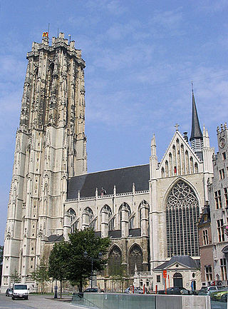
Brabantine Gothic, occasionally called Brabantian Gothic, is a significant variant of Gothic architecture that is typical for the Low Countries. It surfaced in the first half of the 14th century at St. Rumbold's Cathedral in the City of Mechelen.

<span class="mw-page-title-main">Petegem-aan-de-Leie</span> Village in Deinze, Belgium

Petegem-aan-de-Leie is a village in the Belgian province of East Flanders and a borough of Deinze. Petegem-aan-de-Leie is located on the south bank of the river Leie (Lys). The village today forms a single urban core with that of Deinze itself, which is located just across the river.

<span class="mw-page-title-main">County of Flanders</span> Historical territory in present-day Belgium, France, and the Netherlands

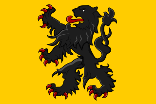
The County of Flanders was one of the most powerful political entities in the medieval Low Countries, located on the North Sea coast of what is now Belgium. Unlike its neighbours such as the counties of Brabant and Hainaut, it was within the territory of the Kingdom of France. The counts of Flanders held the most northerly part of the kingdom, and were among the original twelve peers of France. For centuries, the economic activity of the Flemish cities such as Ghent, Bruges and Ypres made Flanders one of the most affluent regions in Europe, and also gave them strong international connections to trading partners.

<span class="mw-page-title-main">Ename Abbey</span>

Ename Abbey (1063–1795) was a Benedictine monastery in the village of Ename, now a suburb of Oudenaarde. It was founded by Adele of France, wife of Baldwin V, Count of Flanders, and was confiscated during the French Revolutionary Wars. It was then sold and dismantled.

Herman of Ename, was a count in what is now Belgium, who was responsible to the emperor for holding the frontier fort at Ename in the Pagus of Brabant, which faced the County of Flanders in the Kingdom of France.

<span class="mw-page-title-main">Saint Laurentius Church</span> Church in Ename, Belgium

The Saint Laurentius Church of Ename was built shortly before the year 1000 by Herman, Count of Verdun. The only Ottonian building surviving in Ename, it is today the parish church of the village.

<span class="mw-page-title-main">Oosteeklo</span> Place in Flemish Region, Belgium

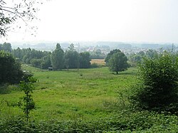
Oosteeklo is a historic village in the Flemish province of East Flanders, Belgium, which since 1977 has been a subdivision of the municipality of Assenede. The village is situated 9 km east of Eeklo and 17 km north of Ghent, about 9 km from the border with the Netherlands, and lies approximately 9 metres above sea-level.

The pagus of Brabant was a geographical region in the early Middle Ages, in what is now Belgium. It was the first region known to have been called Brabant, and it included the modern capital of Belgium, Brussels.

<span class="mw-page-title-main">Ocket Castle</span> Castle in Belgium

Ocket Castle is a house, on the site of a castle, in Heusden, Destelbergen, East Flanders, Belgium. It probably originated on the former fief of Grooten Hoek that lasted until the 15th century. The castle was depicted on a 1725 map by PJ Benthuys as a building with a moat near the Scheldt and is mentioned in 1767 as a "partije genaemt den grieten hoeck met de mote ende huys van playsance". The present Neoclassical building dates largely from the 18th and 19th centuries but contains a dining room on the east side that in the 17th/18th century was the core of the structure, as was established among other things from the beams and the Rococo stucco decorations.

<span class="mw-page-title-main">Jacobus van Eynde</span> Flemish organ builder

Jacobus van Eynde or van den Eynde was a Flemish organ builder.

References

  1. 1 2 "Bevolking per statistische sector - Sector 45035A2". Statistics Belgium. Retrieved 5 May 2022.
  2. Millis, Ludo, Uit het rijke verleden van Ename. 974-1974, Oudenaarde-Ename, 1974, Ill, p. 25
  3. Callebaut, Dirk, Ameels, Vera and De Groote, Koen, Ename Sint-Laurentiuskerk. Archeologisch onderzoek. Voorlopig verslag, Brussel, 2001, p. 18
  4. Vermeulen, Frank, Tussen Leie en Schelde. Archeologische inventaris en studie van de Romeinse bewoning in het zuiden van de Vlaamse Zandstreek, Gent, Arch.I.V, vzw, 1992, pp. 17, 27-36
  5. Van de Walle, A.L.J., 'De Sint-Vedastuskerk te Nederename, een Xe eeuwse praestedelijke moederkerk', Handelingen van de Geschied- en Oudheidkundige Kring van Oudenaarde, dl. X, afl. 1, 1982, pp. 19-31
  6. Berings, Geert, Landschap, geschiedenis en archeologie in het Oudenaardse, Stadsbestuur Oudenaarde, 1989, pp. 39-44
  7. "Paul Budde History  » Brabant emerging".
  8. Callebaut, Dirk, 'Ename and the Ottonian west border policy in the middle Scheldt region', in Exchanging Medieval Material Culture. Studies on archaeology and history presented to Frans Verhaeghe, Relicta Monografieën 4, Brussel, VIOE-VUB, 2010, pp. 217-248
  9. De Groote, Koen and Lemay, Nancy, 'De materiële cultuur in de Sint-Salvatorabdij te Ename. Twee mideeleeuwse latrines uit de westvleugel en een 17 de –eeuwse afvalput uit de priorij', Archeologie in Vlaanderen, Brussel, Instituut voor het Archeologisch Patrimonium, 1993, Dl. 3, pp. 401-418
  10. Tack, Guido, Van Den Bremt, Paul and Hermy, Martin, Bossen van Vlaanderen, Een historische ecologie. Leuven, Davindsfonds, 1993. Krtn., tab., ill., p. 230
  11. Berings, Geert, Landschap, geschiedenis en archeologie in het Oudenaardse, Stadsbestuur Oudenaarde, 1989, p. 39-44
  12. De Inventaris van het Bouwkundig Erfgoed - https://inventaris.onroerenderfgoed.be/dibe/relict/27510