
Drumore Township is a township in southwestern Lancaster County, Pennsylvania, United States. At the 2020 census, the population was 2,568.

Bever is a municipality located in the Belgian province of Flemish Brabant. The municipality only comprises the town of Bever proper. It is located in the Pajottenland. It is located at 50°43′N3°56′E. On January 1, 2018, Bever had a total population of 2,204. The total area is 19.78 km² which gives a population density of 111 inhabitants per km². It is a Dutch-speaking village with language facilities for French-speakers.

Godda district is one of the twenty-four districts of Jharkhand state in eastern India It lies in the northeastern part of the state. The geographical area that now comprises Godda district used to be part of the erstwhile Santhal Parganas district. Godda town is the headquarters of Godda district. The area of the district is 2110 km², with a population of around 1,313,551.
Batu, formerly Zway or Ziway, is a town and woreda on the road connecting Addis Ababa to Nairobi in the East Shewa Zone of Oromia Region, Ethiopia. Batu has a latitude and longitude of 7°56′N38°43′E with an elevation of 1643 meters above sea level.

The Indore District is a district of Madhya Pradesh state in central India. It is believed that the city is named after its Indreshwar Mahadev Temple, Where Indra is the presiding deity. The Gupta inscriptions name Indore as "Indrapura". It is also called the administrative capital. This district forms part of the Indore Division.
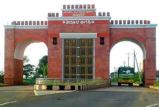
Bagalakote, is a city in the state of Karnataka, India, which is also the headquarters of Bagalakote district. It is situated on branch of River Ghataprabha about 481 km (299 mi) northwest of state capital Bengaluru, 410 km (255 mi) southwest of Hyderabad, and about 570 km (354 mi) southeast of Mumbai. The population of the urban agglomeration was 111,933 according to the provisional results of 2011 national census of India, and the city is spread over an area of 49.06 square kilometres (18.94 sq mi) with an average elevation of 532 m (1,745 ft) above MSL. bagracotta 1832 baugeracotta

Dragoman is the seat of Dragoman Municipality in the Sofia Province, western Bulgaria. The town is located very close to the border with Serbia. As of 2011 the population is 5,362.
Kembibit is a woreda in Oromia Region, Ethiopia. Part of the Kaba Shewa Zone, Kembibit is bordered on the south by Berehna Aleltu, on the west by Wuchalena Jido, on the north by Abichuna Gne'a, and on the east by the Amhara Region. The administrative center of this woreda is Sheno; other towns in Kembibit include Hamus Gebeya and Kotu.

Kampong Tralach is a district (srok) in the south east of Kampong Chhnang province, in central Cambodia. The district capital is Kampong Tralach town located 37 kilometres south of the provincial capital of Kampong Chhnang by road. The district shares a border with Kandal province to the south and Kampong Cham province to the east. The Tonle Sap river runs through the district crossing roughly from north to south.

Brazacorta is a municipality and town located in the province of Burgos, Castile and León, Region of Ribera, Spain. According to the 2007 census (INE), the municipality had a population of 75 inhabitants.
Amboaboa is a town and commune in Madagascar. It belongs to the district of Mandritsara, which is a part of Sofia Region. The population of the commune was estimated to be approximately 13,000 in 2001 commune census.
Ambatonikonilahy is a town and commune in Madagascar. It belongs to the district of Betafo, which is a part of Vakinankaratra Region. The population of the commune was estimated to be approximately 18,000 in 2001 commune census.
Nasandratrony is a rural municipality in Madagascar.
Udaynarayanpur is a community development block that forms an administrative division in Uluberia subdivision of Howrah district in the Indian state of West Bengal.
Shelawadi or Shelavadi is a panchayat town in the southern state of Karnataka, India. It is located in the Navalgund taluk of Dharwad district in Karnataka.
Devakottai taluk is a taluk of Sivagangai district of the Indian state of Tamil Nadu. The headquarters of the taluk is the town of Devakottai

San Fulgencio is a village in the province of Alicante and autonomous community of Valencia, Spain. The municipality covers an area of 19.75 square kilometres (7.63 sq mi) and at the 2011 Census had a population of 9,572, of whom 77% were of foreign origin; the latest official estimate was 7,855. English was the most spoken language in the town
Uğurlubağ is a village in the District of Feke, Adana Province, Turkey.
Barf Anbar Rural District is a rural district (dehestan) in the Central District of Fereydunshahr County, Isfahan Province, Iran. At the 2006 census, its population was 7,717, in 1,774 families. The rural district has 12 villages.
Saguna is a census town in the Kalyani community Development Block in the Kalyani subdivision of the Nadia district in the state of West Bengal, India.