The Godavari is India's second longest river after the Ganga. Its source is in Triambakeshwar, Maharashtra. It flows east for 1,465 kilometres (910 mi), draining the states of Maharashtra (48.6%), Telangana (18.8%), Andhra Pradesh (4.5%), Chhattisgarh (10.9%), Odisha (5.7%),ultimately emptying into the Bay of Bengal through its extensive network of tributaries. Measuring up to 312,812 km2 (120,777 sq mi), it forms one of the largest river basins in the Indian subcontinent, with only the Ganga and Indus rivers having a larger drainage basin. In terms of length, catchment area and discharge, the Godavari is the largest in peninsular India, and had been dubbed as the Vridha Ganga.

Dadra and Nagar Haveli is a region in western India. It is composed of two separate geographical entities: Nagar Haveli, wedged between Maharashtra and Gujarat, and, 1 km to the northwest, the smaller enclave of Dadra, which is surrounded by Gujarat. Silvassa is the administrative headquarters of Dadra and Nagar Haveli. Unlike the surrounding areas, Dadra and Nagar Haveli was ruled by the Portuguese from 1783 until the mid-20th century. The area was captured by Pro-India forces in 1954 and administered as the de-facto state of Free Dadra and Nagar Haveli before being annexed to India as a union territory, the Union Territory of Dadra and Nagar Haveli in 1961. The union territory was merged with the neighboring union territory of Daman and Diu to form the new union territory of Dadra and Nagar Haveli and Daman and Diu on January 26, 2020. The territory of Dadra and Nagar Haveli then became one of the three districts of the new union territory, as the Dadra and Nagar Haveli District.

Ghaghara, also called Karnali is a perennial trans-boundary river originating on the Tibetan Plateau near Lake Manasarovar. It cuts through the Himalayas in Nepal and joins the Sharda River at Brahmaghat in India. Together they form the Ghaghara River, a major left bank tributary of the Ganges. With a length of 507 kilometres (315 mi) it is the longest river in Nepal. The total length of Ghaghara River up to its confluence with the Ganges at Revelganj in Bihar is 1,080 kilometres (670 mi). It is the largest tributary of the Ganges by volume and the second longest tributary of the Ganges by length after Yamuna.

The Daman Ganga also called Dawan River is a river in western India. The river's headwaters are on the western slope of the Western Ghats range, and it flows west into the Arabian Sea. The river flows through Maharashtra and Gujarat states, as well as the Union territory of Dadra and Nagar Haveli and Daman and Diu. The industrial towns of Vapi, Dadra and Silvassa lie on the north bank of the river, and the town of Daman occupies both banks of the river's estuary.

Ahmedabad District comprises the city of Ahmedabad, in the central part of the state of Gujarat in western India. It is the seventh most populous district in India.

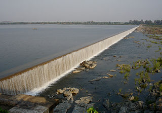
Nizam Sagar Dam is an Indian dam named after the Nizamof Hyderabad. It is a reservoir constructed across the Manjira River, a tributary of the Godavari River, between Achampet and BanjePally villages of the Kamareddy district in Telangana, India. It is located at about 144 km north-west of Hyderabad. Nizam Sagar is the oldest dam in the state of Telangana.

The Sri Rama Sagar Project, also known as the Pochampadu Project is an Indian flood-flow project on the Godavari. The Project is located in Nizamabad district, 3 km away from National Highway 44. It has been described by The Hindu as a "lifeline for a large part of Telangana".

Ambedkar Nagar District is a district in Ayodhya division, Uttar Pradesh, India. This district was created on 29 September 1995 and was named in memory of Bhimrao Ambedkar, who worked for the advancement of the deprived classes, women and other weaker sections of society.

Mirzapur division is a division of Uttar Pradesh state of India. Mirzapur is the administrative headquarters. Currently (2018), the division consists of districts of:

Nanded district is a district of Maharashtra state in central India. The city of Nanded is the district headquarters.

Bidar district is the northernmost part of the Karnataka state in India. Geographically, it resembles the "Crown of the State", occupying its northeastern end. It is bounded by Kamareddy and Sangareddy districts of Telangana state on the eastern side, Latur and Osmanabad districts of Maharashtra state on the western side, Nanded district of Maharashtra state on the northern side and Gulbarga district on the southern side.

Mirzapur district is one of the 75 districts of Uttar Pradesh state in northern India. The district is bounded on the north by Bhadohi and Varanasi districts, on the east by Chandauli district, on the south by Sonbhadra district and on the northwest by Allahabad. The district occupies an area of 4521 km2. Mirzapur city is the district headquarters. Mirzapur district is a part of Mirzapur division. This district is known for the Vindhyavasini temple in Vindhyachal and several tourist attractions like water falls like Rajdari & Devdari and dams. It consist of several Ghats where historical sculptures are still present. During the Ganges festival these Ghats are decorated with lights and diyas. It is a part of the Red Corridor.

Mandya District is an administrative district of Karnataka, India. The district is bordered on the south by Mysore District, on the west by Hassan District, on the north by Tumkur District and on the east by Ramanagar district. The district Mandya was carved out of larger Mysore district in the year 1939.

Katol is a city and a municipal council in Nagpur district of Maharashtra state, India. It is the administrative headquarters of Katol taluka, one of the 14 talukas of this district. Being located in orange belt it is a major centre for orange trading.

Aurad, is an ancient city located in Bidar district in the Indian state of Karnataka. It is the famous for 10th century Sri Amareshwara temple. Amareshwara Jatra Mahotsava is held every year in Mahashivaratri. millions of devotees come to here. It is the birthplace of Bhagwanth Khuba, MP.
Gadhinglaj is a city in the Kolhapur district in the southwestern corner of Maharashtra, India. It is located on the banks of the river Hiranyakeshi. It is the Taluka (Tehsil) headquarters of Gadhinglaj Taluka and a subdivision headquarters of the Gadhinglaj Subdivision of the Kolhapur District. It is governed by a municipal council. The rapidly growing city is the third largest in the Kolhapur District, with population of more than 150000.
Sedam or Seram is a town in Gulbarga district in the Indian state of Karnataka. It is also the headquarters of the Sedam Taluka.

The Manjara also spelled Manjira, Manjeera is a tributary of the river Godavari. It passes through the states of Maharashtra, Karnataka and Telangana. It originates in the Balaghat range of hills near Ahmednagar district at an altitude of 823 metres (2,700 ft) and empties into the Godavari River. It has a total catchment area of 30,844 square kilometres (3,084,400 ha).
Bidar Fort is a fort situated in the Bidar, Karnataka, India. The fort, the city and the district are all affixed with the name Bidar. Sultan Alla-Ud Din Bahman of the Bahmanid Dynasty shifted his capital from Gulbarga to Bidar in 1427 and built his fort along with a number of Islamic monuments. There are over 30 monuments inside Bidar fort.

The Najafgarh drain or Najafgarh nalah, which also acts as Najafgarh drain bird sanctuary, is another name for the northernmost end of River Sahibi, which continues its flow through Delhi, where it is channelized, and then flows into the Yamuna. Within Delhi, due to its channelization for flood control purposes, it is now erroneously called "Najafgarh drain" or "Najafgarh nullah." It gets this name from the once famous and huge Najafgarh Jheel (lake) near the town of Najafgarh in southwest Delhi and within urbanized Delhi. It is the Indian capital’s most polluted water body due to direct inflow of untreated sewage from surrounding populated areas. A January 2005 report by the Central Pollution Control Board classifies this drain, with 13 other highly polluted wetlands, under category ‘‘D’’ for assessing the water quality of wetlands in wildlife habitats.

