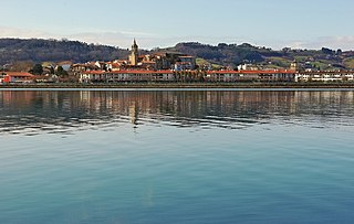
The place-name Bidasoa-Txingudi is a recent creation, combining the name of the river Bidasoa, which here provides a natural frontier between France and Spain in the Basque Country, with that of a bay on the French side of the estuary, the Bay of Txingudi.
It is formed by the towns of Irun and Hondarribia on the Spanish side of the France–Spain border and the neighbouring town of Hendaye (Hendaia) on the French side. In 1999, a decade of efforts to forge closer links between these three municipalities, with a combined population of around 85,000, bore fruit in the launching of a ‘consortium’ set up to undertake cross-frontier projects in the area. In Basque, the consortium is known as Bidasoa-Txingudi Mugaz Gaindiko Partzuergoa, in French as Consorcio transfrontalier Bidasoa-Txingudi and in Spanish as Consorcio Transfronterizo Bidasoa-Txingudi. The French version of the name, using the Spanish word consorcio rather than the French consortium, reflects the fact that it was set up using a Spanish legal vehicle for co-operation between local authorities.
One of the first acts of the promoters of cross-frontier cooperation was to create a new name for the area. Prior to the three towns’ cooperation initiative, the name of the river Bidasoa had been used to define the 'comarca' (a Spanish territorial type of district), which groups Irun and Hondarribia as the Comarca del Bajo Bidasoa. But there had been no common name covering the broader area also including Hendaia. The name Txingudi, written in accordance with modern Basque orthography, was originally applied to a small marshy bay on the edges of Hendaia. In recent years, it had also come to be applied to a marshy area between Irun and Hondarribia which was made into a nature reserve under the protection of the Basque government in 1998, and by extension to the area around the Bidasoa estuary. By combining this name with the name of the river, the initiators of the cross-border project invented a catchy new name, Bidasoa-Txingudi. The bestowing of a new name for the area of Bidasoa-Txingudi supported efforts to create a sense of common identity among people on either side of the frontier and thus bolster acceptance of cross-frontier cooperation. The fact that the promoters of the cooperation project chose to spell the new name in Basque rather than French (Chingoudy) or Spanish (Chingudi) was both a way of emphasizing the common Basque culture on either side of the frontier and a deliberate ploy to provide a stamp of Basque political correctness on the project.
Hendaye is a commune in the Pyrénées-Atlantiques department and Nouvelle-Aquitaine region of southwestern France.
Hondarribia is a town situated on the west shore of Bidasoa river's mouth, in Gipuzkoa, in Basque Country, Spain.
Gipuzkoa is a province of Spain and a historical territory of the autonomous community of the Basque Country. Its capital city is Donostia-San Sebastián. Gipuzkoa shares borders with the French department of Pyrénées-Atlantiques at the northeast, with the province and autonomous community of Navarre at east, Biscay at west, Álava at southwest and the Bay of Biscay to its north. It is located at the easternmost extreme of the Cantabric Sea, in the Bay of Biscay. It has 66 kilometres of coast land.
Irun is a town of the Bidasoaldea region in the province of Gipuzkoa in the Basque Autonomous Community, Spain. It lies on the foundations of the ancient Oiasso, cited as a Roman-Vasconic town during the period.
Pasaia is a town and municipality located in the province of Gipuzkoa in the Basque Autonomous Community of northern Spain. It is a fishing community, commercial port and the birthplace of the famous admiral Blas de Lezo.
Bera is a town and municipality located in the province and autonomous community of Navarre, northern Spain. The river Bidasoa crosses the town before entering Gipuzkoa at Endarlatsa, and joining the Cantabrian Sea between the towns of Hendaye and Hondarribia.
The Bidasoa is a river in the Basque Country of northern Spain and southern France that runs largely south to north. Named as such downstream of the small town of Oronoz-Mugairi in the province of Navarra, the river actually results from the merger of several streams near the village Erratzu, with the stream Baztan that rises at the north-eastern side of the mount Autza being considered the source of the Bidasoa. It joins the Cantabrian Sea between the towns of Hendaye and Hondarribia.
San Sebastián Airport is the airport serving San Sebastián in Basque Country, Spain. Despite its name, the facilities are located in the municipality of Hondarribia, with the runway stretching like a spit of land along the river Bidasoa right on the Spanish-French border.
Oiasso, Oiasona or Oiarso was a Basque Roman town located on the left bank of the Bidasoa estuary in the Bay of Biscay. Archaeological evidence unearthed recently pinpoints the core area of Oiasso in the old quarter of Irun (Gipuzkoa) by the Spanish-French border, where harbour and bath remains have been discovered. However, two other focuses in Cape Higuer and hermitage Ama Xantalen point to a wider complex outside the main nucleus.
San Sebastián or Donostia is a coastal city and municipality located in the Basque Autonomous Community, Spain. It lies on the coast of the Bay of Biscay, 20 km from the French border. The capital city of Gipuzkoa, the municipality's population is 186,095 as of 2015, with its metropolitan area reaching 436,500 in 2010. Locals call themselves donostiarra (singular), both in Spanish and Basque.
The Battle of Irún was the critical battle of the Campaign of Gipuzkoa prior to the War in the North, during the Spanish Civil War. The Nationalist Army, under Alfonso Beorlegui, captured the city of Irún cutting off the northern provinces of Gipuzkoa, Biscay, Santander, and Asturias from their source of arms and support in France.
In the Battle of the Bidasoa on 7 October 1813 the Allied army of Arthur Wellesley, Marquess of Wellington wrested a foothold on French soil from Nicolas Soult's French army. The Allied troops overran the French lines behind the Bidassoa River on the coast and along the Pyrenees crest between the Bidasoa and La Rhune (Larrun). The nearest towns to the fighting are Irun on the lower Bidassoa and Bera on the middle Bidasoa. The battle occurred during the Peninsular War, part of the wider Napoleonic Wars.
Jaizkibel is a mountain range of the Basque Country located east of Pasaia, north of Lezo and west of Hondarribia, in Spain, with 547 m (1,795 ft) at the highest point. The range stretches south-west to north-east, where it plunges into the sea at the Cape Higuer. To the north-west, the mountain dips its slopes in the sea with beautiful cliffs all along, overlooking on the east the marshes of Txingudi, the river Bidasoa and its mouth as well as the towns of Irun, Hendaia and Hondarribia on the river banks. The nearest relevant mountains are La Rhune, Aiako Harria and Ulia ,closing the view east to west from the south. Some people consider Jaizkibel to be the first westernmost mountain of the Pyrenees.
The Cape Higuer is a cape on the Bay of Biscay standing out at the end of the mountain range Jaizkibel by the France–Spain border in the municipality of Hondarribia. The site is home to a lighthouse, besides holding a camp-site and a couple of inns. It is sometimes considered the westernmost land strip of the Pyrenees, with the trek trail GR 11 setting out at this point.
Bidasoaldea is one of the eight eskualdeak/comarcas of Gipuzkoa, Basque Autonomous Community, corresponding to the basin of the lower Bidasoa extending in Gipuzkoan soil and named after the river, in Spain. The region comprises two municipalities, i.e. Hondarribia and Irun. This is the most easterly land strip of Gipuzkoa, bordering on the east with the region of Labourd (France), on the south with the Bortziriak (Navarre), on the west with Oarsoaldea and on the north with the Bay of Biscay.
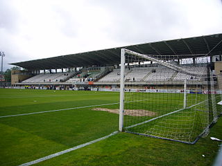
Stadium Gal is a football stadium in Irun, Gipuzkoa, Basque Country, Spain. It is owned by Real Unión, currently in Segunda División B. The capacity of the stadium is 5,000 spectators.
The physical geography of Euskal Herria is very diverse despite the small size of the region. The territory hosts a blend of green and brown to yellowish tones, featuring hilly terrain altogether. The Basque Country spreads from the rough coastal landscape to the semi-desert of the Bardenas on the south-eastern fringes of Navarre.
The Plaiaundi Ecology Park is a 24 -hectare coastal wetland lying where the Bidasoa River meets the sea in the Bay of Biscay. This is in the Basque country of northern Spain, close to the border with France. It is near Irun and Hondarribia in Gipuzkoa, Spain, and Hendaia in France. The confluence of the sea and river have made it one of the most important sites for migratory birds in Europe, with up to 175 species seen visiting the park each year. It is a natural flora and fauna reserve. The park contains three lagoons, two of which are tidal, and a beach.
The Bay of Txingudi is a bay in the right or French bank of the estuary of the Bidasoa river, near Hendaye in the département of Pyrénées-Atlantiques in south-west France. It faces the town of Hondarribia and the airport of San Sebastián in the Gipuzkoa province of the Basque Country, in north-eastern Spain. The border between the two countries passes through the Bidasoa estuary. It is an important area for bird-watching.
The France–Spain border was formally defined in 1659. It separates the two countries from Hendaye and Irun in the west, running through the Pyrenees to Cerbère and Portbou on the Mediterranean Sea.
This page is based on this Wikipedia article Text is available under the CC BY-SA 4.0 license; additional terms may apply. Images, videos and audio are available under their respective licenses.