
Vermilion County is a county in the eastern part of the U.S. state of Illinois, between the Indiana border and Champaign County. It was established in 1826 and was the 45th of Illinois' 102 counties. According to the 2010 United States Census, it had a population of 81,625, a decrease of 2.7% in 2000. It contains 21 incorporated settlements; the county seat and largest city is Danville.

Rock Island County is a county located in the U.S. state of Illinois, bounded on the west by the Mississippi River. According to the 2010 census, it had a population of 147,546. Its county seat is Rock Island; its largest city is neighboring Moline.
Border irregularities of the United States, particularly panhandles and highway incursions into other jurisdictions, are shown here. Often they are a result of borders which do not conform to geological features.
Griggsville Landing, also known as Phillips Landing or Phillips Ferry, was located in Flint Township, just south of Valley City, Illinois. It is a former town site on the Illinois River in Pike County. The town was a steamboat stop which began sometime in the 1830s. There was a lime kiln there that was part of a commercial lime operation prior to post-Civil War industrial intensification in the lime industry. The town at Griggsville Landing was home to a boat yard, a grist mill and a hotel in addition to the Griggsville Landing Lime Kiln, built around 1850, which is still standing as of 2007. The town was eventually abandoned, rendering it a ghost town. Griggsville Landing is adjacent to the Ray Norbut State Fish and Wildlife Area.

Naperville Township is one of nine townships in DuPage County, Illinois, USA. As of the 2010 census, its population was 100,019 and it contained 39,999 housing units.

Colona Township is one of twenty-four townships in Henry County, Illinois, USA. As of the 2010 census, its population was 6,822 and it contained 2,773 housing units. Colona Township changed its name from Green River Township on April 13, 1857.

Derry Township is located in Pike County, Illinois. As of the 2010 census, its population was 247 and it contained 115 housing units.

Hadley Township is located in Pike County, Illinois. As of the 2010 census, its population was 262 and it contained 130 housing units.

Ross Township is located in Pike County, Illinois. As of the 2010 census, its population was 70 and it contained 54 housing units. Ross originally formed as Spring Lake Township from a portion of Atlas Township in July, 1879, but changed its name to Ross shortly after the formation with the exact date unknown.
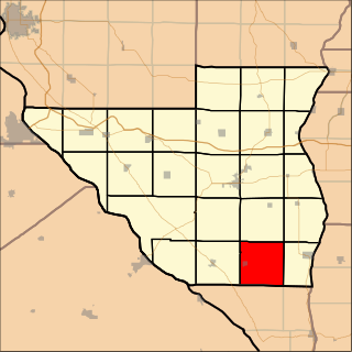
Spring Creek Township is located in Pike County, Illinois. As of the 2010 census, its population was 591 and it contained 295 housing units.

Bluffdale Township is one of thirteen townships in Greene County, Illinois, USA. As of the 2010 census, its population was 556 and it contained 273 housing units.
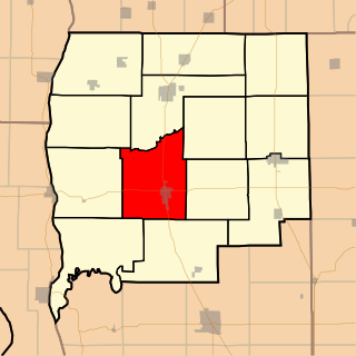
Carrollton Township is one of thirteen townships in Greene County, Illinois, USA. As of the 2010 census, its population was 2,966 and it contained 1,392 housing units.
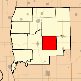
Linder Township is one of thirteen townships in Greene County, Illinois, USA. As of the 2010 census, its population was 345 and it contained 135 housing units.

Patterson Township is one of thirteen townships in Greene County, Illinois, USA. As of the 2010 census, its population was 636 and it contained 282 housing units.

Walkerville Township is one of thirteen townships in Greene County, Illinois, USA. As of the 2010 census, its population was 233 and it contained 111 housing units.

Woodville Township is one of thirteen townships in Greene County, Illinois, USA. As of the 2010 census, its population was 239 and it contained 128 housing units.

Decatur Township is located in Macon County, Illinois. As of the 2010 census, its population was 52,915 and it contained 24,918 housing units.

Pleasant View Township is located in Macon County, Illinois. As of the 2010 census, its population was 1,481 and it contained 620 housing units.

Grand Tower Island is a river island in the Mississippi River in the midwestern United States, within the state of Missouri on its border with the state of Illinois. Formed within recorded history by the movement of the river, it consists of a bulge-shaped piece of land between the river's primary channel and an oxbow lake. Land on the island is generally valuable for farming, especially when protected from flooding, while the lake has developed a reputation as a valuable sport-fishing location.
McEvers Island is an uninhabited fluvial island in the Illinois River. Approximately 1 mile (1.6 km) long, it is legally part of Montezuma Township within Pike County in the U.S. state of Illinois. The island, at Mile 48.5, is often used as a landmark by commercial and pleasure boaters traversing the river. Boaters often anchor or tie up in the narrow, sheltered channel east of the island, bordering the Scott County Illinois mainland.


