
The Bruce Trail is a hiking trail in southern Ontario, Canada, from the Niagara River to the tip of Tobermory, Ontario. The main trail is more than 890 km (550 mi) long and there are over 400 km (250 mi) of associated side trails. The trail mostly follows the edge of the Niagara Escarpment, one of the nineteen UNESCO World Biosphere Reserves in Canada. The land the trail traverses is owned by the Government of Ontario, local municipalities, local conservation authorities, private landowners, and the Bruce Trail Conservancy (BTC). The Bruce Trail is the oldest and longest marked hiking trail in Canada. Its name is linked to the Bruce Peninsula and Bruce County, through which the trail runs. The trail is named after the county, which was named after James Bruce, 8th Earl of Elgin who was Governor General of the Province of Canada from 1847 to 1854.

The Humber River is a river in Southern Ontario, Canada. It is in the Great Lakes Basin, is a tributary of Lake Ontario and is one of two major rivers on either side of the city of Toronto, the other being the Don River to the east. It was designated a Canadian Heritage River on September 24, 1999.

Chatsworth is a township municipality in south-western Ontario, Canada, in Grey County, located at the headwaters of the Styx River, the Saugeen River, the Sauble River, the Bighead River, the Spey River, and the old Sydenham River.

The Rouge River is a river in Markham, Pickering, Richmond Hill and Toronto in the Greater Toronto Area of Ontario, Canada. The river flows from the Oak Ridges Moraine to Lake Ontario at the eastern border of Toronto, and is the location of Rouge Park, the only national park in Canada within a municipality. At its southern end, the Rouge River is the boundary between Toronto and southwestern Pickering in the Regional Municipality of Durham.

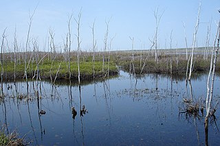
The Nottawasaga River is a river in Simcoe County and Dufferin County in Central Ontario, Canada. It is part of the Great Lakes Basin, and is a tributary of Lake Huron. The river flows from the Orangeville Reservoir in the town of Orangeville, Dufferin County, through the Niagara Escarpment and the Minesing Wetlands, the latter a wetland of international significance, and empties into Nottawasaga Bay, an inlet of Georgian Bay on Lake Huron, at the town of Wasaga Beach, Simcoe County.

The Batchawana River is a river in Algoma and Sudbury Districts of Ontario, Canada, which empties into Batchawana Bay on Lake Superior north of Sault Ste. Marie, Ontario.

The Barron River is a river in the Saint Lawrence River drainage basin in Nipissing District and Renfrew County, Ontario, Canada. It flows from Clemow Lake in northern Algonquin Provincial Park and joins the Petawawa River, whose southern branch it forms, in the municipality of Laurentian Hills, near the municipality of Petawawa.

The Sauble River is a river in Bruce County and Grey County in southwestern Ontario, Canada that flows from its headwaters in the township of Chatsworth to Lake Huron at the community of Sauble Beach.
The Rankin River is a river in the town of South Bruce Peninsula, Bruce County in southwestern Ontario, Canada which flows from the east side of the Bruce Peninsula to join the Sauble River near Sauble Falls Provincial Park on the west side. The river is in the Lake Huron drainage basin and was named after Charles Rankin, who first surveyed the Bruce Peninsula.
The Pottawatomi River is a river in the municipalities of Owen Sound and Georgian Bluffs, Grey County in Southwestern Ontario, Canada.It is in the Great Lakes Basin and empties into Owen Sound, an inlet of Georgian Bay on Lake Huron, at Owen Sound Harbour.

The Crowe River is a river in the counties of Haliburton, Hastings, Northumberland and Peterborough in southern Ontario, Canada. It is in the Lake Ontario drainage basin and is a tributary of the Trent River.
The Black Sturgeon River is a river in Thunder Bay District, Northwestern Ontario, Canada, located west of the Nipigon River, that flows to Lake Superior.
The Brightsand River is a river in the James Bay drainage basin in Unorganized Thunder Bay District in northwestern Ontario, Canada.

The Blue Mountains is a town in Grey County, southwestern Ontario, Canada, located where the Beaver River flows into Nottawasaga Bay. It is named for the Blue Mountain, and hence the economy of the town is centred on tourism, particularly on the Blue Mountain ski resort and the private Georgian Peaks, Osler, Craigleith and Alpine Ski Clubs.
Deerock Lake is a lake in the Moira River in Tweed, Hastings County and Addington Highlands, Lennox and Addington County in Ontario, Canada.

The Cheltenham Badlands are in Caledon, Ontario, on the southeast side of Olde Base Line Road, between Creditview and Chinguacousy Roads. The site occupies an area of approximately 0.4 square kilometers and features exposed and highly eroded Queenston shale. The Cheltenham Badlands are a significant educational site due to the readily visible geologic processes and the red colour and the unique topography of the exposed shale make this a popular tourist site. The site is a Provincial Earth Sciences Area of Natural and Scientific Interest (ANSI) since it is considered one of the best examples of "badlands topography" in Ontario.

The Groundhog River is a river in Cochrane District and Sudbury District in Northeastern Ontario, Canada. The river is in the James Bay drainage basin and is a left tributary of the Mattagami River.
The Boyne River is a river in Simcoe County and Dufferin County in Central Ontario, Canada. It is part of the Great Lakes Basin, and is a left tributary of the Nottawasaga River. The rivers falls within the jurisdiction of the Nottawasaga Valley Conservation Authority.

The Beaver River is a river in Grey County and Simcoe County in Southern Ontario, Canada. It is part of the Great Lakes Basin, and is a tributary of Lake Huron. The river's drainage basin is under the auspices of Grey Sauble Conservation.

The Black River is a river in the Regional Municipality of York and the Regional Municipality of Durham in Central Ontario, Canada. It is part of the Great Lakes Basin, and is a tributary of Lake Simcoe; the entire watershed is under the auspices of the Lake Simcoe Region Conservation Authority.

