
A causewayed enclosure is a type of large prehistoric earthwork common to the early Neolithic in Europe. More than 100 examples are recorded in France and 70 in England, while further sites are known in Scandinavia, Belgium, Germany, Italy, Ireland and Slovakia.
Hambledon Hill is a prehistoric hill fort in Dorset, England, situated in the Blackmore Vale five miles northwest of Blandford Forum. The hill itself is a chalk outcrop, on the southwestern corner of Cranborne Chase, separated from the Dorset Downs by the River Stour. It is owned by the National Trust.
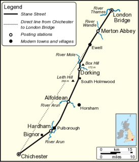
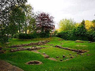
Stane Street is the modern name of the 91 km-long (57 mi) Roman road in southern England that linked Londinium (London) to Noviomagus Reginorum (Chichester). The exact date of construction is uncertain; however, on the basis of archaeological artefacts discovered along the route, it was in use by 70 AD and may have been built in the first decade of the Roman occupation of Britain.

Chanctonbury Ring is a prehistoric hill fort atop Chanctonbury Hill on the South Downs, on the border of the civil parishes of Washington and Wiston in the English county of West Sussex. A ridgeway, now part of the South Downs Way, runs along the hill. It forms part of an ensemble of associated historical features created over a span of more than 2,000 years, including round barrows dating from the Bronze Age to the Saxon periods and dykes dating from the Iron Age and Roman periods.
Newtimber is a small village and civil parish in the Mid Sussex District of West Sussex, England. It is located north-west of Brighton. The parish also includes the hamlet of Saddlescombe. The parish lies almost wholly with the South Downs National Park, with the exception of a small section of the parish north of the B2117 road. The planning authority for Newtimber is therefore the South Downs National Park Authority (SDNPA), the statutory planning authority for the National Park area. The downland scarp, which includes Newtimber Hill, Newtimber Holt, Saddlescombe chalk quarry and Summer Down, is mostly part of the Beeding Hill to Newtimber Hill, designated Site of Special Scientific Interest.

Poynings is a village and civil parish in the Mid Sussex District of West Sussex, England. The parish lies wholly with the South Downs National Park. To its south is Brighton and Hove, to its west is the Fulking parish, to its east is the Newtimber parish and to its north is Albourne parish. The planning authority for Poynings is the South Downs National Park Authority (SDNPA), the statutory planning authority for the National Park area.

Pyecombe is a village and civil parish in the Mid Sussex District of West Sussex, England. The name 'Pyecombe' may derive from the Saxon "pic" meaning point or pike, in which case it may mean "valley marked by a projecting hill".

Upwaltham is a scattered settlement and civil parish in the South Downs, in the District of Chichester of West Sussex, England. It surrounds a parish church, which is about 5 miles (8 km) south-southwest of Petworth on the A285 road.

Lewes Downs is a 165-hectare (410-acre) biological Site of Special Scientific Interest east of Lewes in East Sussex. It is a Nature Conservation Review site, Grade I and a Special Area of Conservation. Part of it is a national nature reserve, part is Malling Down nature reserve, which is managed by the Sussex Wildlife Trust, and part is Mount Caburn, an Iron Age hill fort which is a Scheduled Monument.

Scratchbury Camp is the site of an Iron Age univallate hillfort on Scratchbury Hill, overlooking the Wylye valley about 1 km northeast of the village of Norton Bavant in Wiltshire, England. The fort covers an area of 37 acres (15 ha) and occupies the summit of the hill on the edge of Salisbury Plain, with its four-sided shape largely following the natural contours of the hill.
The Devil's Humps are four Bronze Age barrows situated on Bow Hill on the South Downs near Stoughton, West Sussex. They are situated on a downland ridgeway crossed by an ancient trackway, above Kingley Vale. The Devil's Humps are counted among the most impressive round barrows surviving on the South Downs. The Devil's Humps are within the Kingley Vale National Nature Reserve. The two bell barrows together with two pond barrows and a cross dyke are listed as Scheduled Ancient Monument 1008371, while the two bowl barrows are listed as Scheduled Ancient Monument 1008372.

Knap Hill lies on the northern rim of the Vale of Pewsey, in northern Wiltshire, England, about a mile north of the village of Alton Priors. At the top of the hill is a causewayed enclosure, a form of Neolithic earthwork that was constructed in England from about 3700 BC onwards, characterized by the full or partial enclosure of an area with ditches that are interrupted by gaps, or causeways. Their purpose is not known—they may have been settlements, or meeting places, or ritual sites of some kind. The site has been scheduled as an ancient monument.
Whitehawk Hill is a 50.3-hectare (124-acre) Local Nature Reserve in Brighton, East Sussex. It is owned and managed by Brighton and Hove City Council.

Beacon Hill, also known as Harting Beacon, is a hillfort on the South Downs, in the county of West Sussex in southern England. The hillfort is located in the parish of Elsted and Treyford, in Chichester District. It is a Scheduled Ancient Monument with a list entry identification number of 1015915. The hilltop enclosure is dated to the Late Bronze Age, from the 8th to 6th centuries BC. The hillfort defences were renewed during the Late Iron Age.

Hollingbury Castle, also known as Hollingbury Camp and Hollingbury Hillfort, is an Iron Age hillfort on the northern edge of Brighton, in East Sussex, England. It is adjacent to Hollingbury Park Golf Course.
This is a list of scheduled monuments in the English county of Lancashire.

The Martin Down Enclosure is an archaeological site on Martin Down, near the village of Martin, in Hampshire, England. It is near the boundaries with Dorset and Wiltshire.

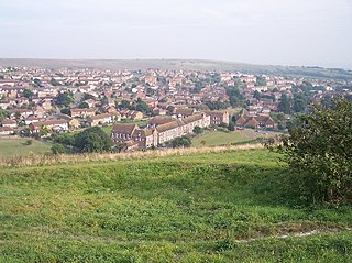
Thundersbarrow Hill is an archaeological site in West Sussex, England. It is on a chalk ridge, aligned north-west to south-east, on the South Downs north of Shoreham-by-Sea.
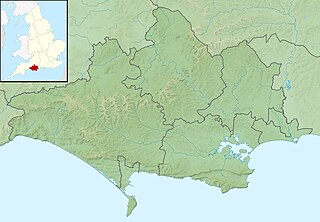
Barkhale Camp is a Neolithic causewayed enclosure, an archaeological site on the South Downs in West Sussex, England. It is about 1 mile (1.6 km) south-west of the village of Bignor.

