Chalk heath

Last updated

Chalk heath is a rare habitat, in the temperate grasslands, savannas, and shrublands biome, formed of a paradoxical mixture of shallow-rooted calcifuge ("calcium-hating") and deeper-rooted calcicole ("calcium-loving") plants, growing on a thin layer of acidic soil over an alkaline substrate. Chalk heath is intermediate between two much more widespread habitats, chalk grassland and heathland.

Temperate grasslands, savannas, and shrublands Habitats and climate of : temperate grasslands

Temperate grasslands, savannahs, and shrublands is a terrestrial habitat type defined by the World Wide Fund for Nature. The predominant vegetation in this biome consists of grass and/or shrubs. The climate is temperate and ranges from semi-arid to semi-humid. The habitat type differs from tropical grasslands in the annual temperature regime as well as the types of species found here.

Biome Distinct biological communities that have formed in response to a shared physical climate

A biome is a community of plants and animals that have common characteristics for the environment they exist in. They can be found over a range of continents. Biomes are distinct biological communities that have formed in response to a shared physical climate. "Biome" is a broader term than "habitat"; any biome can comprise a variety of habitats.

A calcifuge is a plant that does not tolerate alkaline (basic) soil. The word is derived from the Latin 'to flee from chalk'. These plants are also described as ericaceous, as the prototypical calcifuge is the genus Erica (heaths). It is not the presence of carbonate or hydroxide ions per se that these plants cannot tolerate, but the fact that under alkaline conditions, iron becomes less soluble. Consequently, calcifuges grown on alkaline soils often develop the symptoms of iron deficiency, i.e. interveinal chlorosis of new growth. There are many horticultural plants which are calcifuges, most of which require an 'ericaceous' compost with a low pH, composed principally of Sphagnum moss peat.

Contents

Ecology

Chalk heath occurs where a thin layer of acidic soil (often loess or sand) overlies a basic (alkaline) one, such as chalk. Shallow-rooted plants grow only in the acidic soil (typically a few centimetres thick), and so these are species characteristic of acidic habitats. Deeper-rooted plants can reach the underlying alkaline substrate, and so these include species characteristic of alkaline habitats. Plants also occur which are able to tolerate both acidic and basic conditions. There are no plants restricted entirely to chalk heath, and the animals are also those characteristic of chalk grassland and heathland. The vegetation structure of chalk heath resembles grass heath, being short grassy vegetation with heather growing up through it, with some scattered heather bushes.

Loess A predominantly silt-sized clastic sediment of accumulated wind-blown dust

Loess is a clastic, predominantly silt-sized sediment that is formed by the accumulation of wind-blown dust. 10% of the Earth's land area is covered by loess or similar deposits.

Sand A granular material composed of finely divided rock and mineral particles, from 0.063 to 2 mm diameter

Sand is a granular material composed of finely divided rock and mineral particles. It is defined by size, being finer than gravel and coarser than silt. Sand can also refer to a textural class of soil or soil type; i.e., a soil containing more than 85 percent sand-sized particles by mass.

Base (chemistry) substance that can accept hydrogen ions (protons) or more generally, donate a pair of valence electrons

In chemistry, bases are substances that, in aqueous solution, release hydroxide (OH) ions, are slippery to the touch, can taste bitter if an alkali, change the color of indicators (e.g., turn red litmus paper blue), react with acids to form salts, promote certain chemical reactions (base catalysis), accept protons from any proton donor or contain completely or partially displaceable OH ions. Examples of bases are the hydroxides of the alkali metals and the alkaline earth metals (NaOH, Ca(OH)2, etc.—see alkali hydroxide and alkaline earth hydroxide).

Chalk heath often occurs at the tops of slopes, at the thin margins of acidic deposits which often cap the flatter tops of chalk hills. It usually gives way to chalk grassland on lower slopes where these deposits have been eroded away, and often to heathland on the hilltops where the acidic deposits are thicker. Chalk heath tends to occur as narrow strips and scattered fragments, being limited to places where the conditions are exactly right for its development and survival.

Chalk heath is a grazing habitat, created and maintained by livestock (usually sheep and cattle) and rabbits.

Grazing method of feeding in which a herbivore eats parts of low-growing grasses, forbs or algae

Grazing is a method of feeding in which a herbivore feeds on plants such as grasses, or other multicellular organisms such as algae. In agriculture, grazing is one method used whereby domestic livestock are used to convert grass and other forage into meat, milk and other products.

Livestock Domesticated animals

Livestock is commonly defined as domesticated animals raised in an agricultural setting to produce labor and commodities such as meat, eggs, milk, fur, leather, and wool. The term is sometimes used to refer solely to those that are bred for consumption, while other times it refers only to farmed ruminants, such as cattle and goats. Horses are considered livestock in the United States.

Sheep Domesticated ruminant bred for meat, wool and milk

Domestic sheep are quadrupedal, ruminant mammals typically kept as livestock. Like most ruminants, sheep are members of the order Artiodactyla, the even-toed ungulates. Although the name sheep applies to many species in the genus Ovis, in everyday usage it almost always refers to Ovis aries. Numbering a little over one billion, domestic sheep are also the most numerous species of sheep. An adult female sheep is referred to as a ewe, an intact male as a ram or occasionally a tup, a castrated male as a wether, and a younger sheep as a lamb.

Vegetation

Chalk heath in southern Britain includes calcicoles such as salad burnet (Sanguisorba minor), dropwort ( Filipendula vulgaris ) and common milkwort ( Polygala vulgaris ), and calcifuges such as bell heather ( Erica cinerea ), ling heather ( Calluna vulgaris), heath grass ( Danthonia decumbens ), sheep's sorrel (Rumex acetosella) and betony ( Stachys officinalis ). It also includes plants which can tolerate both acidic and basic conditions, such as common bent ( Agrostis capillaris ), wood sage ( Teucrium scorodonia ) and sometimes juniper ( Juniperus communis ).

Great Britain island in the North Atlantic off the north-west coast of continental Europe

Great Britain is an island in the North Atlantic Ocean off the northwest coast of continental Europe. With an area of 209,331 km2 (80,823 sq mi), it is the largest of the British Isles, the largest European island, and the ninth-largest island in the world. In 2011, Great Britain had a population of about 61 million people, making it the world's third-most populous island after Java in Indonesia and Honshu in Japan. The island of Ireland is situated to the west of Great Britain, and together these islands, along with over 1,000 smaller surrounding islands, form the British Isles archipelago.

<i>Filipendula vulgaris</i> species of plant, Dropwort

Filipendula vulgaris, commonly known as dropwort or fern-leaf dropwort, is a perennial herb of the family Rosaceae closely related to Meadowsweet. It is found in dry pastures across much of Europe and central and northern Asia mostly on lime.

<i>Polygala vulgaris</i> species of plant

Polygala vulgaris, known as the common milkwort, is a herbaceous perennial plant of the genus Polygala belonging to the Polygalaceae family.

Conservation

Chalk heath has suffered a parallel decline to those of heathland and chalk grassland, but because of the scattered and fragmented distribution of suitable soil conditions it has declined even more than those habitats. Many examples have disappeared due to agricultural improvement, or to a lack of grazing management, which leads to replacement by species-poor scrub and woodland. Chalk heath is especially sensitive to soil disturbance such as ploughing, which mixes the thin layer of acidic soil with the chalk beneath.

Plough tool or farm implement

A plough (UK) or plow is a tool or farm implement used in farming for initial cultivation of soil in preparation for sowing seed or planting to loosen or turn the soil. Ploughs were traditionally drawn by working animals such as oxen and horses, but in modern times are mostly drawn by tractors. A plough may be made of wood, iron, or steel frame with an attached blade or stick used to cut the soil and loosen it. It has been a basic instrument for most of recorded history, although despite archeological evidence for its use written references to the plough do not appear in the English language before c. 1100, after which point it is referenced frequently. The plough represents one of the major agricultural inventions in human history. The earliest ploughs were wheelless, and the Romans used a wheelless plough called the aratrum, but Celtic peoples began using wheeled ploughs during the Roman era.

Example locations

Surrey County of England

Surrey is a subdivision of the English region of South East England in the United Kingdom. A historic and ceremonial county, Surrey is also one of the home counties. The county borders Kent to the east, East and West Sussex to the south, Hampshire to the west, Berkshire to the northwest, and Greater London to the northeast.

England Country in north-west Europe, part of the United Kingdom

England is a country that is part of the United Kingdom. It shares land borders with Wales to the west and Scotland to the north-northwest. The Irish Sea lies west of England and the Celtic Sea lies to the southwest. England is separated from continental Europe by the North Sea to the east and the English Channel to the south. The country covers five-eighths of the island of Great Britain, which lies in the North Atlantic, and includes over 100 smaller islands, such as the Isles of Scilly and the Isle of Wight.

Lullington Heath human settlement in United Kingdom

Lullington Heath is a 72.7-hectare (180-acre) biological Site of Special Scientific Interest west of Eastbourne in East Sussex. It is a National Nature Reserve and a Nature Conservation Review site, Grade I.

See also

Related Research Articles

Calcareous grassland an ecosystem associated with thin basic soil

Calcareous grassland is an ecosystem associated with thin basic soil, such as that on chalk and limestone downland. Plants on calcareous grassland are typically short and hardy, and include grasses and herbs such as clover. Calcareous grassland is an important habitat for insects, particularly butterflies, and is kept at a plagioclimax by grazing animals, usually sheep and sometimes cattle. Rabbits used to play a part but due to the onset of myxomatosis their numbers decreased so dramatically that they no longer have much of a grazing effect.

North Downs ridge of chalk hills in south east England

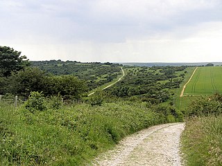
The North Downs are a ridge of chalk hills in south east England that stretch from Farnham in Surrey to the White Cliffs of Dover in Kent. Westerham Heights, at the northern edge of the North Downs, near Bromley, South London, is the highest point in London at an elevation of 245 m (804 ft). The North Downs lie within two Areas of Outstanding Natural Beauty (AONBs), the Surrey Hills and the Kent Downs. The North Downs Way National Trail runs along the North Downs from Farnham to Dover.

Heath shrubland habitat

A heath is a shrubland habitat found mainly on free-draining infertile, acidic soils and is characterised by open, low-growing woody vegetation. Moorland is generally related to high-ground heaths with—especially in Great Britain—a cooler and damper climate.

A calcicole, calciphyte or calciphile is a plant that thrives in lime rich soil. The word is derived from the Latin 'to dwell on chalk'. Under acidic conditions, aluminium becomes more soluble and phosphate less. As a consequence, calcicoles grown on acidic soils often develop the symptoms of aluminium toxicity, i.e. necrosis, and phosphate deficiency, i.e. anthocyanosis and stunting.

This article gives an overview of the calcicolous grassland communities in the British National Vegetation Classification system.

St Boniface Down mountain in United Kingdom

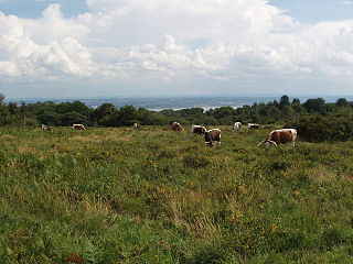
St Boniface Down is a chalk down on the Isle of Wight, England. It is located close to the town of Ventnor, in the southeast of the Island, and rises to 241 metres (791 ft), the Island's highest point, 1 kilometre (0.6 mi) north of the town. There is reputed to be a wishing well on its southern slope, which requires the wisher to climb up from the south without looking back. In 1545 a French invasion force attempted this against a force of the Isle of Wight Militia commanded by Sir John Fyssher- which allegedly included several women archers- and were routed. In 1940 the radar station was bombed by Ju 87 Stuka dive bombers, which is reconstructed in the film "The Battle of Britain". The top is surmounted by a round barrow.

Scotstown Moor

Scotstown Moor is in the north of Aberdeen, Scotland.

Gentleshaw Common

Gentleshaw Common is an area of common land situated in Gentleshaw on the northern side of Burntwood in Staffordshire, England. The area is a Site of Special Scientific Interest as it is an area of globally rare lowland heathland. The common plays host to a series of fun public events throughout the year, including scrub bashing and countryside walks.

Base-richness in ecology is the level in water or soil of chemical bases, such as calcium or magnesium ions. Many organisms are restricted to base-rich environments. Chemical bases are alkalis, and so base-rich environments are neutral or alkaline. Because base-poor environments have few bases, they are dominated by environmental acids and so are acidic. However, the relationship between base-richness and acidity is not a rigid one – changes in the levels of acids may significantly change acidity without affecting base-richness.

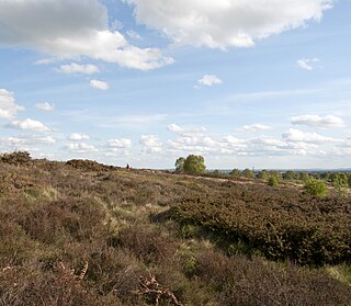
Lowland Heath is a Biodiversity Action Plan habitat as it is a type of ancient wild landscape. Natural England's Environmental Stewardship scheme describes lowland heath as containing dry heath, wet heath and valley mire communities, usually below 250 metres in altitude, on acidic soils and shallow peat, typically comprising heathers, gorses, fine grasses, wild flowers and lichens in a complex mosaic. Heathers and other dwarf shrubs usually account for at least 25% of the ground cover. By contrast, upland heath, which is above 300 metres in altitude, is called Moorland, Dartmoor being an example.

Woolmer Forest

Woolmer Forest is a royal hunting forest. It lies within the western Weald in the South Downs National Park, straddling the border between east Hampshire and West Sussex. Covering an area of some 1,293.9 hectares, it is both a Special Area of Conservation and a Site of Special Scientific Interest. Historically a largely treeless heathland on sterile sandy soils, the forest was traditionally managed, like other royal forests, as "wood pasture" in which deer would be kept for hunting by the aristocracy for sport and for venison, and where commoners were permitted to graze their livestock. The forest today consists of both dry and humid lowland heath. It contains the largest and most diverse area of lowland heathland habitats outside the New Forest and is considered to be the most important area of heathland in the Weald of southern England; it is the only site in England known to support all twelve known native species of reptiles and amphibians, and it supports a nationally important heathland flora with associated birds and invertebrate fauna.

Allerthorpe Common

Allerthorpe Common is a Site of Special Scientific Interest (SSSI) and nature reserve in the East Riding of Yorkshire, England. It is located close to the town of Pocklington. The site, which was designated a SSSI in 1951, lies on river and lake sands, which were deposited during the last glacial period 12-10,000 years ago. The soils are acidic and a variety of habitats, including wet and dry heath, mire, grassland and woodland have formed. The drier areas are dominated by heather interspersed with cross-leaved heath and purple moor grass. In the wetter areas purple moor grass forms dense tussocks. Common cottongrass and marsh cinquefoil occur in the wet mire conditions.

Sound Heath

Sound Heath, also known as Sound Common, is an area of common land in Sound, near Nantwich in Cheshire, England, which includes heathland, grassland, scrub, woodland and wetland habitats. The majority of the area is designated a Site of Special Scientific Interest and a Local Nature Reserve.

Waldridge Fell

Waldridge Fell is a Site of Special Scientific Interest located immediately south-west of Chester-le-Street in the northern part of County Durham, England. It is one of the largest areas of lowland heath in County Durham and contains the only lowland valley-mire in the county. The fell is home to a number of plants and insects that are scarce to rare elsewhere in the county.

Poors Allotment biological Site of Special Scientific Interest in Gloucestershire, UK

Poor's Allotment is a 28.57-hectare (70.6-acre) biological Site of Special Scientific Interest in Gloucestershire, notified in 1954. The site is listed in the 'Forest of Dean Local Plan Review' as a Key Wildlife Site (KWS).

Hartland Moor

Hartland Moor is a Site of Special Scientific Interest (SSSI) on the south side of Poole Harbour near the town of Wareham in Dorset, England. It consists of lowland heathland.

Allolee to Walltown

Allolee to Walltown is the name given to a Site of Special Scientific Interest (SSSI) in Northumberland, England. The site, which follows the path of a section of Hadrian's Wall, is notable for an unusually wide range of grassland types growing on thin soil above the Whin Sill, a rock formation peculiar to the Northern Pennines.

Arcot Hall Grasslands and Ponds

Arcot Hall Grasslands and Ponds is the name given to a Site of Special Scientific Interest (SSSI) near Cramlington in Northumberland, England, notable as the largest lowland species-rich grassland in North East England. The site is composed of grassland, heath, ponds, and associated damp habitats now rare in Northumberland.

References