The Kings River, is a 132.9-mile (213.9 km) river draining the Sierra Nevada mountain range in central California in the United States. Its headwaters originate along the Sierra Crest in and around Kings Canyon National Park and form the eponymous Kings Canyon, one of the deepest river gorges in North America. The river is impounded in Pine Flat Lake before flowing into the San Joaquin Valley southeast of Fresno. With its upper and middle course in Fresno County, the Kings River diverges into multiple branches in Kings County, with some water flowing south to the old Tulare Lake bed and the rest flowing north to the San Joaquin River. However, most of the water is consumed for irrigation well upstream of either point.

Friant Dam is a concrete gravity dam on the San Joaquin River in central California in the United States, on the boundary of Fresno and Madera Counties. It was built between 1937 and 1942 as part of a U.S. Bureau of Reclamation (USBR) water project to provide irrigation water to the southern San Joaquin Valley. The dam impounds Millerton Lake, a 4,900-acre (2,000 ha) reservoir about 15 miles (24 km) north of Fresno.

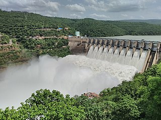
Pine Flat Dam is a concrete gravity dam on the Kings River in the Central Valley of Fresno County, California United States. Situated about 28 miles (45 km) east of Fresno, the dam is 440 feet (130 m) high and impounds Pine Flat Lake, in the foothills of the Sierra Nevada just outside the boundary of Kings Canyon National Park. The dam's primary purpose is flood control, with irrigation, hydroelectric power generation and recreation secondary in importance.

The Sriram Sagar Project is also known as the Pochampadu Project is an Indian flood-flow project on the Godavari. The Project is located in Nizamabad district, 3 km away from National Highway 44. It has been described by The Hindu as a "lifeline for a large part of Telangana".

The Solo River is the longest river in the Indonesian island of Java, it is approximately 600 km (370 mi) in length.

Gomal Zam Dam is a multi-purpose gravity dam in South Waziristan Tribal District of Khyber Pakhtunkhwa, Pakistan. The dam impounds the Gomal River, a tributary of the Indus River, at Khjori Kach, where the Gomal River passes through a narrow ravine. The purpose of the dam is irrigation, flood control, and hydroelectric power generation. Construction of the dam began in August 2001 and was completed in April 2011. The powerhouse was completed in March 2013 and electricity production started in August 2013. The dam was officially inaugurated on 12 September 2013 by Minister for Water and Power Khawaja Muhammad Asif, along with US Ambassador Richard G. Olson and Khyber Pakhtunkhwa Governor Shaukatullah Khan.

Hirakud Dam is built across the Mahanadi River, about 10 kilometres (6.2 mi) from Sambalpur in the state of Odisha in India. It is the longest earthen dam in the world. Behind the dam extends a lake, Hirakud Reservoir, 55 km (34 mi) long. It is one of the first major multipurpose river valley projects started after India's independence. Hirakud Reservoir was declared a Ramsar site on 12 October 2021.
The Srisailam Dam is constructed across the Krishna River in Nandyal district, Andhra Pradesh and Nagarkurnool district, Telangana near Srisailam temple town and is the 2nd largest capacity working hydroelectric station in India.

River Vamsadhara or River Banshadhara is an important east flowing river between Rushikulya and Godavari, in Odisha and Andhra Pradesh states in India.

Perunchani Dam is an irrigation dam at Perunchani, Kanyakumari District, in the state of Tamil Nadu, India. It is one of the dams of the Kodayar Irrigation System. As there was water deficiency in the Kodayar Irrigation System, Perunchani Dam was constructed in December 1952 to store flood water of the Paralayar River as an extension. It was built about 1 km (0.62 mi) upstream of the Puthen dam on the Paralayar River. The irrigation system became operational on 2 September 1953. It feeds the left bank irrigation canal system of the Puthen dam, which is the terminal structure of the system.

The Rio Grande Project is a United States Bureau of Reclamation irrigation, hydroelectricity, flood control, and interbasin water transfer project serving the upper Rio Grande basin in the southwestern United States. The project irrigates 193,000 acres (780 km2) along the river in the states of New Mexico and Texas. Approximately 60 percent of this land is in New Mexico. Some water is also allotted to Mexico to irrigate some 25,000 acres (100 km2) on the south side of the river. The project was authorized in 1905, but its final features were not implemented until the early 1950s.

Shihmen Dam is a major rock fill dam across the Dahan River in northern Taoyuan City. It forms the Shihmen Reservoir (石門水庫), Taiwan's third largest reservoir or artificial lake. It provides irrigation in Taoyuan, flood control for the Taipei Basin, and hydroelectricity and domestic water supply for more than three million people in northern Taiwan.

The Minidoka Project is a series of public works by the U.S. Bureau of Reclamation to control the flow of the Snake River in Wyoming and Idaho, supplying irrigation water to farmlands in Idaho. One of the oldest Bureau of Reclamation projects in the United States, the project involves a series of dams and canals intended to store, regulate and distribute the waters of the Snake, with electric power generation as a byproduct. The water irrigates more than a million acres (4,000 km²) of otherwise arid land, producing much of Idaho's potato crop. Other crops include alfalfa, fruit and sugar beets. The primary irrigation district lies between Ashton in eastern Idaho and Bliss in the southwestern corner of the state. Five main reservoirs collect water, distributing it through 1,600 miles (2,600 km) of canals and 4,000 miles (6,400 km) of lateral distribution ditches.
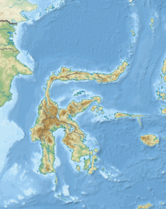
The Jeneberang is a river of approximately 75 km in length in the south-western half of the island of Sulawesi, Indonesia. The catchment has an area of 760 square kilometers.

The Upper Wardha Dam is an earthfill straight gravity dam across the Wardha River, a tributary of the Godavari River, near Simbhora village in Morshi taluk in Amravati district in the Indian state of Maharashtra. The dam provides multipurpose benefits of irrigation, drinking water supply, flood control and hydropower generation.

Zengwen Dam, also spelled Tsengwen Dam, is a major earthen dam in Dapu Township, Chiayi County, Taiwan on the Zengwen River. It is the third tallest dam in Taiwan, and forms Zengwen Reservoir (曾文水庫), the biggest reservoir in Taiwan by volume. The dam stores water for irrigation of the Chianan Plain, Taiwan's most productive agricultural region, and provides flood control along the Zengwen River which flows through Tainan City. The dam supports a 50 megawatt hydroelectric power station.

The Jatigede Dam is an embankment dam on the Cimanuk River in Sumedang Regency, West Java, Indonesia. It is located 19 km (12 mi) east of the town of Sumedang. Construction on the dam began in 2008 and it was completed in 2015. The power station is expected to be commissioned in 2019. The primary purpose of the dam is irrigation but it will also provide for flood control, water supply and hydroelectric power generation. Water in the reservoir will be used to help irrigate 90,000 ha of farmland and the power station is expected to have a 110 MW capacity. The project has become controversial, primarily due to the relocation of people in the future reservoir zone.

The Middle Rio Grande Project manages water in the Albuquerque Basin of New Mexico, United States. It includes major upgrades and extensions to the irrigation facilities built by the Middle Rio Grande Conservancy District and modifications to the channel of the Rio Grande to control sedimentation and flooding. The bulk of the work was done by the United States Bureau of Reclamation and the United States Army Corps of Engineers in the 1950s, but construction continued into the 1970s and maintenance is ongoing. The project is complementary to the San Juan–Chama Project, which transfers water from the San Juan River in the Colorado River Basin to the Rio Grande. Although distribution of water from the two projects is handled through separate allotments and contracts, there is some sharing of facilities including the river itself. The ecological impact on the river and the riparian zone was the subject of extended litigation after a group of environmentalists filed Rio Grande Silvery Minnow v. Bureau of Reclamation in 1999.

Kherkatta Dam is a medium irrigation project built across the Kotri River, about 10 km (6.2 mi) northwest of Kapsi in the Kanker district of Chhattisgarh, India. It is the largest dam of the district and gets its name from the neighbouring village of Kherkatta. The lake that the dam forms behind it is officially known as the Paralkot Reservoir, which extends in a northwest direction and partially into the Mohla-Manpur-Ambagarh Chowki district. The distance of the dam is approximately 20 km (12 mi) from Pakhanjur, 35 km (22 mi) from Manpur and 110 km (68 mi) from Kanker.
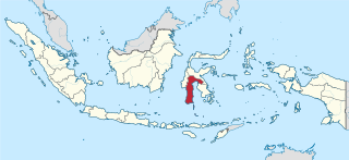
On 22 January 2019, floods caused by heavy rainfall struck the Indonesian province of South Sulawesi. At least 68 people were killed and thousands were displaced. Gowa Regency was particularly hard-hit, experiencing the majority of the fatalities.