Last updated • 2 min readFrom Wikipedia, The Free Encyclopedia
Fjord in Svalbard, Norway
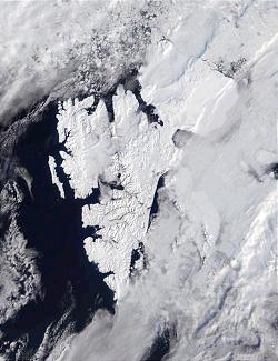
Billfjorden (labelled e) is on Spitsbergen's west coast
Billefjorden is the central fjord of the three branching from the innermost part of the Isfjorden to the northeast, in Svalbard, Norway. It is 30km long and 5–8km wide. Billefjorden lies between Dickson Land to the northwest and Bünsow Land in the southeast. Located on its northwestern shore is the former Russian coal mining community of Pyramiden (abandoned in 1998).[1] To the northeast is Nordenskiöldbreen (Nordenskiöld Glacier). At its northeastern extreme is Adolf Bay.[2]
The fjord is named after the Dutch whaler Cornelius Claeszoon Bille, who is mentioned as being active in 1675 by the Dutch whaler Cornelius Gisbert Zorgdrager.[3] Originally another bay (now known as Adventfjorden) had been labeled as Klass Billen Bay, but Dunér and Nordenskiöld moved it to its present location.
The fjord is the site of the Billefjorden Fault Zone, which continues to the north and separates Svalbard’s north-eastern and north-western terranes.[4][5] In addition to the Pyramidan coal, gypsum is mined on the north side of the bay, at Skansbukta.[6]
Sources
Conway, W. M. 1906. No Man's Land: A History of Spitsbergen from Its Discovery in 1596 to the Beginning of the Scientific Exploration of the Country. Cambridge: At the University Press.
↑ in his book Grænlandische Vischerey en de walvischvangst.
↑ Manby, Geoffrey M.; Lyberis, Nicolas; Chorowicz, Jean; Thiedig, Friedhlem (1994). "Post-Caledonian tectonics along the Billefjorden Fault Zone, Svalbard, and implications for the Arctic region". Geological Society of America Bulletin. 106 (2): 201–216. doi:10.1130/0016-7606(1994)105<0201:PCTATB>2.3.CO;2.
Svalbard, previously known as Spitsbergen or Spitzbergen, is a Norwegian archipelago in the Arctic Ocean. North of mainland Europe, it lies about midway between the northern coast of Norway and the North Pole. The islands of the group range from 74° to 81° north latitude, and from 10° to 35° east longitude. The largest island is Spitsbergen, followed in size by Nordaustlandet and Edgeøya. The largest settlement is Longyearbyen on the west coast of Spitsbergen.
Svalbard is an archipelago in the Arctic Ocean roughly centered on 78° north latitude and 20° east longitude. It constitutes the northernmost territory of the Kingdom of Norway. The three main islands in the group consist of Spitsbergen, Nordaustlandet and Edgeøya. There are also a number of smaller islands, such as Barents Island (Barentsøya), Kvitøya, Prins Karls Forland, Kongsøya, Bear Island, Svenskøya, Wilhelm Island and other smaller islands or skerries.
Spitsbergen, is the largest and the only permanently populated island of the Svalbard archipelago in northern Norway.
Nils Adolf Erik Nordenskiöld was a Finland-Swedish aristocrat, geologist, mineralogist and Arctic explorer. He was a member of the Fenno-Swedish Nordenskiöld family of scientists and held the title of a friherre (baron). His ethnicity was Finnish-Swedish.
Barentsburg is the second-largest settlement in Svalbard, Norway, with about 455 inhabitants (2020). A coal mining town, the settlement was almost entirely made up of ethnic Russians and Ukrainians. With the 2022 Russian invasion of Ukraine, most of the Ukrainian citizens were reported to have left.
The polar archipelago of Svalbard was first discovered by Willem Barentsz in 1596, although there is disputed evidence of use by Pomors or Norsemen. Whaling for bowhead whales started in 1611, dominated by English and Dutch companies, though other countries participated. At that time there was no agreement about sovereignty. Whaling stations, the largest being Smeerenburg, were built during the 17th century, but gradually whaling decreased. Hunting was carried out from the 17th century by Pomors, but from the 19th century it became more dominated by Norwegians.
Alfred Gabriel Nathorst was a Swedish Arctic explorer, geologist, and palaeobotanist.
Pyramiden is an abandoned Soviet coal mining settlement on the Norwegian archipelago of Svalbard which has become a tourist destination. Founded by Sweden in 1910 and sold to the Soviet Union in 1927, Pyramiden was closed in 1998 and has since remained largely abandoned with most of its infrastructure and buildings still in place, the cold climate preserving much of what has been left behind.
Van Mijenfjorden is the third-longest fjord in Norway's Svalbard archipelago. It lies in the southern portion of Spitsbergen island, south of Nordenskiöld Land and north of Nathorst Land. The fjord is 83 km (52 mi) long, being separated from Bellsund further out by Akseløya and Mariaholmen. The settlement of Sveagruva lies on the fjord's north bank.
Kongsfjorden is an inlet on the west coast of Spitsbergen, an island which is part of the Svalbard archipelago in the Arctic Ocean. The inlet is 26 km (16 mi) long and ranges in width from 6 to 14 km. Two glaciers, Kronebreen and Kongsvegen, head the fjord.
Grønfjorden is a 16 km long fjord, separated from Isfjorden to the north by Festningsodden in the west and Heerodden in the east. It lies within the western portion of Nordenskiöld Land. On its eastern shore is the mining community of Barentsburg, the second largest settlement on Spitsbergen.
Kobbefjorden is a small fjord on the west coast of Danes Island, on the northwestern coast of Spitsbergen, the largest island of the Svalbard archipelago. The fjord is about two miles (3.5 km) long and 1-1.2 miles (1.5–2 km) wide. It offers one of the best anchorages on Spitsbergen's northwest coast, "being sheltered from most winds and ice-free for much of the year." At the head of the fjord is a valley, Kobbefjorddalen, which leads to the east coast of Danes Island. Kobbefjorden's southwesternmost point is Luftskipodden. Sir Martin Conway, on his visit to Spitsbergen in 1896–97, described the fjord as having "ice-smoothed hills of [the] hardest rock."
The economy of Svalbard is dominated by coal mining, tourism and research. In 2007, there were 484 people working in the mining sector, 211 people working in the tourism sector and 111 people working in the education sector. The same year, mining gave a revenue of 2.008 billion kr, tourism NOK 317 million and research 142 million. In 2006, the average income for economically active people was NOK 494,700, or 23% higher than on the mainland. Almost all housing is owned by the various employers and institutions and rented to their employees; there are only a few privately owned houses, most of which are recreational cabins. Because of this, it is nearly impossible to live on Svalbard without working for an established institution. The Spitsbergen Treaty and Svalbard Act established Svalbard as an economic free zone and demilitarized zone in 1925.
Indre Wijdefjorden National Park is located in a steep fjord landscape in northern Spitsbergen in Svalbard, Norway. It covers the inner part of Wijdefjorden—the longest fjord on Svalbard. The national park was established on 9 September 2005 and covers 1,127 km2 (435 sq mi), of which 745 km2 (288 sq mi) is on land and 382 km2 (147 sq mi) is sea. The marine environment changes vastly from the mouth of the fjord, through a still, cold, water basin, becoming deeper before reaching the glacier Mittag-Lefflerbreen at the inner-most sections of the fjord.
Nordenskiöldbreen is a glacier in Spitsbergen, Svalbard. It is named after Finnish geologist Adolf Erik Nordenskiöld (1832–1901).
Nordenskiöld Land is the land area between Isfjorden and Van Mijenfjorden on Spitsbergen, Svalbard. The area is named after Finnish-Swedish explorer and geologist Nils Adolf Erik Nordenskiöld. The coastal region of Nordenskiöld Land (Nordenskiøldkysten) has been identified as an Important Bird Area (IBA) by BirdLife International because it supports breeding populations of barnacle geese and common eiders.
Dickson Land is a land area between Isfjorden and Wijdefjorden at Spitsbergen, Svalbard. It forms a peninsula between the Isfjorden branches Billefjorden and Dicksonfjorden. Dickson Land is named after Oscar Dickson.
Petuniabukta is a bay in Dickson Land at Spitsbergen, Svalbard. It constitutes the northern branch of Billefjorden. The bay is named after the Scottish vessel SS Petunia. Northwest of the bay is the valley of Hørbyedalen and the glacier of Hørbyebreen.
The geology of Svalbard encompasses the geological description of rock types found in Svalbard, and the associated tectonics and sedimentological history of soils and rocks. The geological exploration of Svalbard is an ongoing activity, and recent understandings may differ from earlier interpretations.
This page is based on this Wikipedia article Text is available under the CC BY-SA 4.0 license; additional terms may apply. Images, videos and audio are available under their respective licenses.