
The Atbarah River, also referred to as the Red Nile and / or Black Nile, is a river in northeast Africa. It rises in northwest Ethiopia, approximately 50 km north of Lake Tana and 30 km west of Gondar. It then flows about 805 km (500 mi) to the Nile in north-central Sudan, joining it at the city of Atbarah. The river's tributary, the Tekezé (Setit) River, is perhaps the true upper course of the Atbarah, as the Tekezé follows the longer course prior to the confluence of the two rivers in northeastern Sudan. The Atbarah is the last tributary of the Nile before it reaches the Mediterranean.
Famines in Ethiopia have occurred periodically throughout the history of the country.

The Bashilo River is located in Ethiopia. Known for its canyon, which one source describes as almost as extensive as the canyon of its parent the Abay, also known as the Blue Nile, the river originates just west of Kutaber in the Amhara Region. Flowing first in a northwesterly direction to where the Tergiya empties into it, it then heads southwest to its confluence with the Abay. Its drainage area is about 13,242 square kilometres in size, covering portions of the Semien Gondar, Semien Wollo and Debub Wollo Zones. Its tributaries include the Checheho, and the Walano.
Nunu Kumba is one of 180 woredas in the Oromia Region of Ethiopia. Part of the East Welega Zone, Nunu Kumba is bordered on the southwest by the Didessa River which separates it from the Illubabor Zone, on the northwest by Jimma Arjo, on the north by Guto Wayu, on the northeast by Wama Bonaya, and on the southeast by the Wama which separates it from the Jimma Zone. The administrative center of this woreda is Nunu.
Bedele nanowa is one of the woredas in the Oromia Region of Ethiopia. Part of the Illubabor Zone, Bedele Zuria is bordered on the south by Gechi, on the southwest by Chora, on the west by Dega, on the north by the southern exclave of the Benishangul-Gumuz Region, on the northeast by the Didessa River which separates it from the Misraq Welega Zone, and on the southeast by Gechi. Towns in Bedele Zuria include Bedele. Bedele Zuria, Chewaka, Dabo Hana woredas and Bedele town were part of former Bedele woreda.
Ibantu is one of woredas in the Oromia Region of Ethiopia. Part of the East Welega Zone, Ibantu is bordered on the south by Limmu, on the west and north by the Benishangul-Gumuz Region, and on the east by Gida Kiremu. The administrative center of this woreda is Hinde.
Hitosa is one of the woredas in the Oromia Region of Ethiopia. The woreda of Lude Hitosa was separated from Hitosa. Part of the Arsi Zone, Hitosa is bordered on the south by Digeluna Tijo, on the southwest by Tiyo, on the west by Batu Dugda, on the northwest by the East Shewa Zone, on the northeast by Dodotana Sire, and on the east by Tena. The administrative center of the woreda is Iteya; other towns include Borujawi and Ligaba.
Sude is one of the woredas in the Oromia Region of Ethiopia. Part of the Arsi Zone, Sude is bordered on the south by Robe, on the southwest by Tena, on the west by Dodotana Sire, on the northwest by Jeju, on the north by Merti, on the northeast by Chole and on the southeast by Amigna. The administrative center of the woreda is Kula.
Berbere is a woreda in Oromia Region, Ethiopia. Part of the Bale Zone, Berbere is bordered on the south by Mennana Harena Buluk, on the northwest by Goba, on the north by Sinanana Dinsho, on the northeast by Goro, and on the east by Guradamole; the Mena River separates it from Shinanana Dinsho and Goro. The administrative center of the woreda is Haro Dumal.
Rayitu is one of the Districts in the Oromia Region of Ethiopia. Located in East Bale zone or Eastern part of the Bale Zone, Rayitu is bordered on the south by the Somali Region, on the west by Ginir, and on the north and east by Seweyna; the Gestro River defines the southwest boundary. Towns in Raytu include Dhedecha Bela Town.
The Reb is a river of north-central Ethiopia which empties into Lake Tana in a small delta. The river originates on the slopes of Mount Guna, and flows west through Kemekem woreda. It has no significant tributaries.
The Jamma River is a river in central Ethiopia and a tributary to the Abay. It drains parts of the Semien Shewa Zones of the Amhara and Oromia Regions. The Upper Jamma flows through steep, deep canyons cut first through volcanic rock and then through the Cretaceous sandstone and shaly sandstone, with Jurassic limestone at the bottom. It has a drainage area of about 15,782 square kilometers in size. Tributaries include the Wanchet.
The Walaqa River, a tributary of the Blue Nile, is a river in the Amhara Region of Ethiopia. Wegde is located to its north. Mida Woremo and Dera are to the south, while Kelala is to the northeast. The Walaqa River may have been the northern boundary of the historical province of Walaqa.
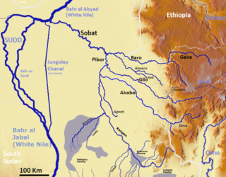
Alwero River is a river in Abobo woreda of Gambela Region, Ethiopia. It flows through the Gambela National Park and through wetlands into the Openo/Baro River.

The Gumara is a river of northern-western Ethiopia. It empties into Lake Tana into a bird's-foot delta from the east. Hot springs on the Gumara's banks at Wanzaye, which were popular in medicinal hot baths from the late 18th century till now, were already mentioned by missionary Henry Stern.
Jikawo River is a river of southwestern Ethiopia. It is a tributary of the Baro River, which it joins at latitude and longitude 8°22′N33°46′E.
The Sor is a river of southwestern Ethiopia. A tributary of the Birbir River on its left side and joins it at latitude and longitude 8°30′48″N35°11′17″E, the Sor rises in Sayo.
The Yabus River rises in the far west of Ethiopia, in Asosa Zone, flows west into Sudan past the town of Yabus, then enters South Sudan. At the town of Bunj it turns south west and enters the Machar Marshes, where it loses its identity.
The Gebba is a river of southwestern Ethiopia. It is a tributary of the Baro River, which is created at the confluence of the Gebba and the Birbir. The river is the planned site for the twin Gebba Hydro electric power dams.
The Daga River is a river in South Sudan. It rises in the mountains of the Mirab Welega Zone in Ethiopia, just east of the South Sudan-Ethiopia border, where it is known as the Deqe Sonka Shet. It flows west past the town of Daga Post and discharges into the Machar Marshes.
