Bird atlas

Last updated

A bird atlas is an ornithological work that attempts to provide information on the distribution, abundance, long-term change as well as seasonal patterns of bird occurrence and make extensive use of maps. They often involve a large numbers of volunteers to cover a wide geographic area and the methods used are standardized so that the studies can be continued in the future and the results remain comparable. In some cases the species covered may be restricted to those that breed or are resident. Migration atlases on the other hand cover migratory birds depict maps showing summaries of ringing and recoveries. [1]

Contents

Summer distribution and abundance of Canada goose using data from the North American Breeding Bird Surveys 1994-2003 CanadaGooseSummer19942003.png
Summer distribution and abundance of Canada goose using data from the North American Breeding Bird Surveys 1994-2003

Bird atlases vary in methodology but they always involve spatial (locations) and temporal (time) components. A typical bird atlas project collates data on bird presence or abundance with mapping of this information over a significant geographical region over a well-defined period of time. Data gathered in other efforts, such as breeding bird surveys and eBird, may also contribute to atlas projects. [1]

History

The earliest published mapping of biodiversity in the form of an atlas was completed for the flora of Britain - Atlas of the British Flora (1962) [2] The first bird atlas, the Atlas of breeding birds of the West Midlands, covered Staffordshire, Warwickshire and Worcestershire (England) and was published by Collins for the West Midland Bird Club, in 1970., [3] It built on work done by the Club and its subsequent president, Tony Norris, for its West Midland Bird Distribution Survey, circulated privately in 1951, [4] which mapped frequency of sightings and breeding densities against districts based on the boundaries of Rural District Councils. [4] [5] The British Trust for Ornithology published updated atlases, covering Britain and Ireland, in 1993 and 2013. The West Midlands atlas influenced and was followed by the 1976 Atlas of Breeding Birds in Britain and Ireland. [6] [7] In the US, the first breeding bird atlas to be published was for the State of Vermont. [8] In the decades that followed a number of atlases have been made all over the world and by 2008 atlases had summarised as many as 27.9 million records of birds gathered by at least 108000 contributors, over an area covering roughly 31.4% of the world's land. [1] While early atlases focused on merely the presence or absence of species and evidence of their breeding, there is an increasing trend towards those that indicate abundance or relative abundance. [9]

Methods

In the oldest and most popular sampling approach, the region to be covered is gridded and volunteers are expected to visit representative locations within each grid cell and gather data that is subsequently collated. The method of collecting data, time and season in which to obtain the sample information are pre-decided as part of a protocol. In some cases the numbers and species of birds that are found to be breeding are recorded, others may use timed point sampling or transects within the grid cells to obtain quantitative estimates of abundance. [1] In some countries the grid cells follow the latitudes and longitudes - cell intervals of 1 degree, 30 and 15 minutes are often chosen for convenience. In higher latitudes where such an approaches leads to grid cells with large differences in area, sizes are more often fixed using grid distances of 1, 2, 5, 10 or even 50 km grid intervals. [10] The Oregon Breeding Bird Atlas addressed this by using hexagonal survey units, which cover a spherical surface such as the earth without changing size. [11] The hexagons, each with an area of 435 square kilometers, also contained a survey unit of 25 square kilometers. A disadvantage with grids of any type is that boundaries rarely match those of habitats, making them unsuitable for some types of ecological studies. [7] Another problem is that the data collected in one project cannot be readily reused with new grid alignments that may be needed for instance when combining information with other projects. Repeat atlases made after a decade or two have helped in identifying long term range changes. [12] Recommendations and guidance stemming from the cumulative experience of state and provincial atlas projects is provided in handbooks of the North American Ornithological Atlas Committee (NORAC), published in English, French, and Spanish [13] [14]

Another approach that does not need pre-defined grids makes use of the coordinates of individual points. Coordinates may be determined from maps or using GPS devices, and the point densities can be interpolated to generate grid or contour maps. The Summer Atlas of North American Birds (1995) is one such example that makes use of such point data (not using grids) collected by the North American Breeding Bird Surveys. [15] Others such as the EPOQ atlas for Quebec in Canada use 'trip lists', lists of birds seen at a place on a trip. [16] A problem in atlas projects is the unequal distribution of available observers resulting in some grid cells having too few visits. Sometimes it is possible to make corrections for the differences in the sampling effort. Reporting rates are often used as a simple quantitative indicator. [10] A framework has also been developed to incorporate monitoring data, hierarchical modelling and sampling simulations to augment occurrence and breeding status maps with species abundances. [17]

Applications

Changes in abundance of Canada goose between 1966 and 2003 identified using data from the North American Breeding Bird Surveys CanadaGooseTrend19662003.png
Changes in abundance of Canada goose between 1966 and 2003 identified using data from the North American Breeding Bird Surveys

Some authors note the distinction between the published "atlas" (usually a book but sometimes are web based systems or CD-ROM as was the case for Oregon) and the actual atlas data. The data itself cannot be recovered back from published atlases for alternate applications unless made separately available as an electronic database. Depending on the methodology used, there can be multiple applications for atlas data. [7]

Atlases at a minimum, have an educational and recreational value. They provide information on the current distributions of birds and may be used by birdwatchers to assess the importance of their own observation records, learn more about species, or to plan trips. Distribution maps in atlases are usually far more accurate and detailed than those in field guides. [7]

Atlases document distributions and populations for conservation and research. Species distribution ranges are important in assessing conservation criteria. Patterns of sympatry and allopatry are better observed when measures of relative abundance are also collected. [18] When atlas projects are repeated over time it is possible to note changes in distribution. Reasons for change may be sought to identify causes when these changes are significant. Ecological niche models may be built to identify factors that are significant in influencing the occurrence of species. Many studies have examined the distributions of rare species and have noted that they often do not occur in species-rich areas. [19] Studies using atlas data have helped in identifying key sites for conservation. [20] Atlas data has also been used to identify biogeographic zones. [21]

Atlases have helped in resolving taxonomic problems. DNA studies had shown that the two 'subspecies' of Eupodotis afra were distinct. The southern African atlas was able to demonstrate that these two 'subspecies' were disjunct in distribution except for a small area of overlap. The earlier distribution maps (made using what has been termed the 'shade-the-triangle' method) were totally misleading. [12]

Atlas projects can involve several countries. The Southern African Bird Atlas Project (SABAP) was started in 1986 with data gathered from six countries: Botswana, Lesotho, Namibia, South Africa, Swaziland and Zimbabwe. This resulted in a published book form atlas in 1997 [22] and the database held seven million distribution records. It has been used by planners, conservationists, researchers and for ecotourism apart from being used in over fifty research papers and eight academic dissertations. [23]

Bird atlases can also serve as a guide for more detailed research. Atlas data can be used to develop sampling and survey designs for intensive studies. [7]

See also

Related Research Articles

<span class="mw-page-title-main">Ornithology</span> Study of birds

Ornithology is a branch of zoology that concerns the study of birds. Several aspects of ornithology differ from related disciplines, due partly to the high visibility and the aesthetic appeal of birds. It has also been an area with a large contribution made by amateurs in terms of time, resources, and financial support. Studies on birds have helped develop key concepts in biology including evolution, behaviour and ecology such as the definition of species, the process of speciation, instinct, learning, ecological niches, guilds, island biogeography, phylogeography, and conservation.

<span class="mw-page-title-main">Glossy ibis</span> Species of bird

The glossy ibis is a water bird in the order Pelecaniformes and the ibis and spoonbill family Threskiornithidae. The scientific name derives from Ancient Greek plegados and Latin, falcis, both meaning "sickle" and referring to the distinctive shape of the bill.

<span class="mw-page-title-main">Common scoter</span> Species of bird

The common scoter is a large sea duck, 43–54 cm (17–21 in) in length, which breeds over the far north of Europe and the Palearctic east to the Olenyok River. The genus name is derived from Ancient Greek melas, "black", and netta, "duck". The species name is from Latin niger "shining black". The black scoter of North America and eastern Siberia is sometimes considered a subspecies of M. nigra.

The West Midland Bird Club is the UK's largest regional ornithological society. It has been serving birdwatchers and ornithologists in the four English counties of Staffordshire, Warwickshire, Worcestershire and the Metropolitan West Midlands, with lectures, field trips, research, a bulletin and an annual report, since 1929. It is a registered charity in England and Wales, number 213311.

<span class="mw-page-title-main">British Trust for Ornithology</span>

The British Trust for Ornithology (BTO) is an organisation founded in 1932 for the study of birds in the British Isles. The Prince of Wales has been patron since October 2020.

A breeding bird survey monitors the status and trends of bird populations. Data from the survey are an important source for the range maps found in field guides. The North American Breeding Bird Survey is a joint project of the United States Geological Survey (USGS) and the Canadian Wildlife Service. The UK Breeding Bird Survey is administered by the British Trust for Ornithology, the Joint Nature Conservation Committee, and the Royal Society for the Protection of Birds.

QDGC - Quarter Degree Grid Cells are a way of dividing the longitude latitude degree square cells into smaller squares, forming in effect a system of geocodes. Historically QDGC has been used in a lot of African atlases. Several African biodiversity projects uses QDGC, among which The atlas of Southern African Birds is the most prominent one. In 2009 a paper by Larsen et al. describes the QDGC standard in detail.

The Cornell Lab of Ornithology is a member-supported unit of Cornell University in Ithaca, New York, which studies birds and other wildlife. It is housed in the Imogene Powers Johnson Center for Birds and Biodiversity in Sapsucker Woods Sanctuary. Approximately 250 scientists, professors, staff, and students work in a variety of programs devoted to the Lab's mission: interpreting and conserving the Earth's biological diversity through research, education, and citizen science focused on birds. Work at the Lab is supported primarily by its 75,000 members.

<span class="mw-page-title-main">Species distribution</span> Geographical area in which a species can be found

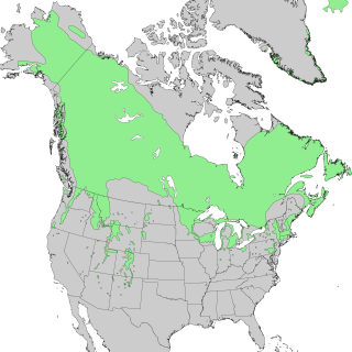
Species distribution, or speciesdispersion, is the manner in which a biological taxon is spatially arranged. The geographic limits of a particular taxon's distribution is its range, often represented as shaded areas on a map. Patterns of distribution change depending on the scale at which they are viewed, from the arrangement of individuals within a small family unit, to patterns within a population, or the distribution of the entire species as a whole (range). Species distribution is not to be confused with dispersal, which is the movement of individuals away from their region of origin or from a population center of high density.

<span class="mw-page-title-main">Atlas of Australian Birds</span>

The Atlas of Australian Birds is a major ongoing database project initiated and managed by BirdLife Australia to map the distribution of Australia's bird species. BirdLife Australia is a not-for-profit bird research and conservation organisation.

The Australian Bird Count (ABC) was a project of the Royal Australasian Ornithologists Union (RAOU). Following the first and successful Atlas of Australian Birds project, which led to the publication of a book on the distribution of Australian birds in 1984, it was suggested by Ken Rogers that the RAOU should next look at bird migration and other movements in Australia. Methodology for a suitable project involving volunteers was worked out through experimental fieldwork and a workshop on ‘Monitoring the Populations and Movements of Australian Birds’.

<span class="mw-page-title-main">Little eagle</span> One of the closest living relatives of the Haasts eagle, along with the booted eagle

The little eagle is a very small eagle endemic to Australia.

<i>The EBCC Atlas of European Breeding Birds</i>

The EBCC Atlas of European Breeding Birds - Their Distribution and Abundance (ISBN 0-85661-091-7) is an ornithological atlas published for the European Bird Census Council by T & A D Poyser in 1997. Its editors were Ward J. M. Hagemeijer and Michael J. Blair. The atlas was the first to present grid-square distribution maps for all breeding birds at a Europe-wide level. The bulk of the book is in English, although it also contains introductions in thirteen other European languages. The atlas presents the results of the European Bird Census Council's European Ornithological Atlas project, the fieldwork for which was carried out between 1985 and 1988.

In ecology, the occupancy–abundance (O–A) relationship is the relationship between the abundance of species and the size of their ranges within a region. This relationship is perhaps one of the most well-documented relationships in macroecology, and applies both intra- and interspecifically. In most cases, the O–A relationship is a positive relationship. Although an O–A relationship would be expected, given that a species colonizing a region must pass through the origin and could reach some theoretical maximum abundance and distribution, the relationship described here is somewhat more substantial, in that observed changes in range are associated with greater-than-proportional changes in abundance. Although this relationship appears to be pervasive, and has important implications for the conservation of endangered species, the mechanism(s) underlying it remain poorly understood

The Tennessee Ornithological Society (TOS) is an independent non-profit educational, scientific, and conservation organization in Tennessee, United States, dedicated to the study and conservation of birds. It was formed in 1915 and has published a quarterly journal, The Migrant, since 1930. The organization conducts statewide meetings and its local chapters have regular meetings and field trips.

SABAP2 is the acronym for the Southern African Bird Atlas Project 2, which is the follow-up to the Southern African Bird Atlas Project. The first atlas project took place from 1987 to 1991. The current project was a joint venture between the Animal Demography Unit at the University of Cape Town, BirdLife South Africa, and the South African National Biodiversity Institute (SANBI). Following the closure of the Animal Demography Unit, the project is now managed by the FitzPatrick Institute of African Ornithology, University of Cape Town. The project aims to map the distribution and relative abundance of birds in southern Africa, and the original atlas area included South Africa, Lesotho, and Eswatini, although since 2012 the project has expanded to include Namibia, Botswana, Zimbabwe and Mozambique. SABAP2 was launched on 1 July 2007. The field work for this project is conducted by more than 1700 volunteers, known as citizen scientists – they collect the data in the field at their own cost and in their own time. As such they make a huge contribution to the conservation of birds and their habitat.

The Sussex Ornithological Society (SOS) is a British registered charity dedicated to the study, recording, and conservation of wild birds and their habitats in the English historic county of Sussex. It was founded in 1962 and is one of the largest county bird clubs in Great Britain with a membership of 1988 as at the end of financial year in December 2014.

The Southern African Bird Atlas Project (SABAP) was conducted between 1987 and 1991. Because a new bird atlas was started in southern Africa in 2007, the earlier project is now referred to as SABAP1. The new atlas project is known as the Second Southern African Bird Atlas Project, and is abbreviated to SABAP2. The project is ongoing, and is now managed by the FitzPatrick Institute of African Ornithology at the University of Cape Town. Most of the data capture happens through the application BirdLasser. The project is currently funded by BirdLife South Africa and the South African National Biodiversity Institute.

The Biodiversity Monitoring Switzerland (BDM) is a Swiss Confederation programme for the long-term monitoring of species diversity in Switzerland.

References

  1. 1 2 3 4 Dunn, Andrew M.; Michael A. Weston (2008). "A review of terrestrial bird atlases of the world and their application". Emu. 108: 42–67. doi:10.1071/MU07034. S2CID   83786727.
  2. Perring, F.H. & Walters, S.M. (1962) Atlas of the British Flora. Botanical Society of the British Isles & T. Nelson, London.
  3. Lord, John; Dennis Johnstone Munns; T. K. Beck; A. J. Richards (1970). Atlas of breeding birds of the West Midlands. London: Published for the West Midland Bird Club (by) Collins. pp. 3–276p(chiefly illus, form, maps), 20cm. ISBN   978-0-00-211040-2. Archived from the original on 5 February 2012.{{cite book}}: CS1 maint: unfit URL (link)
  4. 1 2 Norris, C A (1951). West Midland Bird Distribution Survey. West Midland Bird Club. Archived from the original on 2 April 2012.{{cite book}}: CS1 maint: unfit URL (link) (published for private circulation)
  5. "Sample page from 1951 survey". Archived from the original on 2 April 2012.{{cite web}}: CS1 maint: unfit URL (link)
  6. Sharrock, J.T.R. (1976) The Atlas of Breeding Birds in Britain and Ireland. T. & A.D. Poyser, Berkhamsted.
  7. 1 2 3 4 5 Donald, Paul F.; Robert J. Fuller (1998). "Ornithological atlas data: a review of uses and limitations". Bird Study. 45 (2): 129–145. doi: 10.1080/00063659809461086 .
  8. Laughlin, Sarah B., and Douglas P. Kibbe (eds.). 1985. The atlas of breeding birds of Vermont. Vermont Inst. of Natural Science, Woodstock, VT. 456 p.
  9. Gibbons, David W; Donald, Paul F; Bauer, Hans-Günther; Fornasari, Lorenzo; Dawson, Ian K (2010). "Mapping avian distributions: The evolution of bird atlases". Bird Study. 54 (3): 324. doi: 10.1080/00063650709461492 .
  10. 1 2 Norris, Ken; Deborah J. Pain (2002) Conserving Bird Biodiversity: General Principles and Their Application. Cambridge University Press. ISBN   0-521-78949-4
  11. Adamus, P.R., K. Larsen, G. Gillson, and C. Miller. 2001. Oregon Breeding Bird Atlas. Oregon Field Ornithologists, Eugene, OR. CD-ROM. ISBN   1-877693-30-8.
  12. 1 2 Underhill, Les; D. Gibbons (2002). "Mapping and monitoring bird populations: their conservation uses". In Norris, Ken; Pain, Deborah J. (eds.). Conserving Bird Biodiversity: General Principles and Their Application.
  13. Smith, Charles (1991). "Handbook for Atlasing North American Breeding Birds". North American Ornithological Atlas Committee. Retrieved 28 July 2018.
  14. Beck, G.G., A.R. Couturier, C.M. Francis, and S. Leckie (2018). North American Ornithological Atlas Committee Handbook: A Guide for Managers on the Planning and Implementation of a Breeding Bird Atlas Project. Port Rowan, Ontario, Canada: Bird Studies Canada.{{cite book}}: CS1 maint: multiple names: authors list (link)
  15. Jeff Price, Sam Droege, & Amy Price (1995) The Summer Atlas of North American Birds. Princeton University Press. ISBN   978-0-12-564660-4
  16. Cyr, Andre & J Larivée (1995) L'Atlas saisonnier des oiseaux du Québec.
  17. Mccabe, J.D.; Anich, N.M.; Brady, R.S.; Zuckerberg, B. (2018). "Raising the bar for the next generation of biological atlases: using existing data to inform the design and implementation of atlas monitoring". Ibis. 160 (3): 528–541. doi:10.1111/ibi.12561.
  18. Harrison, J.A. (1989). Atlassing as a tool in conservation, with special reference to the Southern African Bird Atlas Project. In: Biotic Diversity in Southern Africa: Concepts and Conservation (ed. B.J. Huntley), pp. 157-169. Oxford University Press, Cape Town.
  19. Prendergast, J. R; Quinn, R. M; Lawton, J. H; Eversham, B. C; Gibbons, D. W (1993). "Rare species, the coincidence of diversity hotspots and conservation strategies". Nature. 365 (6444): 335. doi:10.1038/365335a0. S2CID   4310788.
  20. Williams, Paul; Gibbons, David; Margules, Chris; Rebelo, Anthony; Humphries, Chris; Pressey, Robert (1996). "A Comparison of Richness Hotspots, Rarity Hotspots, and Complementary Areas for Conserving Diversity of British Birds". Conservation Biology. 10: 155–174. doi:10.1046/j.1523-1739.1996.10010155.x.
  21. Carey, P. D; Preston, C. D; Hill, M. O; Usher, M. B; Wright, S. M (1995). "An Environmentally Defined Biogeographical Zonation of Scotland Designed to Reflect Species Distributions". The Journal of Ecology. 83 (5): 833. doi:10.2307/2261420. JSTOR   2261420.
  22. Harrison, J.A., Allan, D.G., Underhill, L.G., Herremans, M., Tree, A.J., Parker, V. & Brown, C.J. (eds) 1997. The Atlas of Southern African birds. Vol. 1: Non-passerines. Vol. 2: Passerines. Johannesburg: BirdLife South Africa
  23. Harrison, J.A.; Underhill, L.G.; Barnard, P. (2008). "The seminal legacy of the Southern African Bird Atlas Project". South African Journal of Science. 104: 82–84.