The Isle of Lewis (Scottish Gaelic: Eilean Leòdhais or simply Lewis is the northern part of Lewis and Harris, the largest island of the Western Isles or Outer Hebrides archipelago in Scotland. The two parts are frequently referred to as if they were separate islands. The total area of Lewis is 683 square miles.

Rutland Water is a reservoir in Rutland, England, east of the county town, Oakham. It is filled by pumping from the River Nene and River Welland and provides water to the East Midlands. It is one of the largest artificial lakes in Europe. By surface area it is the largest reservoir in England, but by capacity it is exceeded by Kielder Water.
The Environment Agency (EA) is a non-departmental public body, established in 1995 and sponsored by the United Kingdom government's Department for Environment, Food and Rural Affairs (DEFRA), with responsibilities relating to the protection and enhancement of the environment in England.

The Macquarie Marshes Nature Reserve is a protected natural wetland reserve that is located within the Macquarie Marshes, in the region along the lower Macquarie River in northwestern New South Wales, Australia. The 19,824-hectare (48,990-acre) reserve is situated approximately 600 kilometres (370 mi) northwest of Sydney and 100 kilometres (62 mi) north of Warren.

Loch Leven is a fresh water loch located immediately to the east of the burgh of Kinross in Perth and Kinross council area, central Scotland. Roughly triangular, the loch is about 6 km (3.7 mi) at its longest. Prior to the canalisation of the River Leven, and the partial draining of the loch in 1826-36, Loch Leven was considerably larger. The drop in water level by 1.4 m reduced to the loch to 75% of its former size, and exposed several small islands, as well as greatly increasing the size of the existing ones.

Loch Maree is a loch in Wester Ross in the Northwest Highlands of Scotland. At 21.7 km (13.46 mi) long and with a maximum width of 4 km (2.5 mi), it is the fourth largest freshwater loch in Scotland; it is the largest north of Loch Ness. Its surface area is 28.7 km2 (11.08 sq mi).

The Cotswold Water Park is the United Kingdom's largest marl lake system, straddling the Wiltshire–Gloucestershire border, northwest of Cricklade and south of Cirencester. The lakes were created in the second half of the 20th century by extraction of glacial Jurassic limestone gravel, which had eroded from the Cotswold Hills, and these filled naturally after working began to cease in the early 1970s.

The Mississippi River Delta is the confluence of the Mississippi River with the Gulf of Mexico in Louisiana, southeastern United States. The river delta is a three-million-acre area of land that stretches from Vermilion Bay on the west, to the Chandeleur Islands in the east, on Louisiana's southeastern coast. It is part of the American Mediterranean Sea and the Louisiana coastal plain, one of the largest areas of coastal wetlands in the United States. The Mississippi River Delta is the 7th largest river delta on Earth (USGS) and is an important coastal region for the United States, containing more than 2.7 million acres of coastal wetlands and 37% of the estuarine marsh in the conterminous U.S. The coastal area is the nation's largest drainage basin and drains about 41% of the contiguous United States into the Gulf of Mexico at an average rate of 470,000 cubic feet per second.

The Scottish Environment Protection Agency is Scotland’s environmental regulator and national flood forecasting, flood warning and strategic flood risk management authority. Its main role is to protect and improve Scotland's environment. SEPA does this by helping business and industry to understand their environmental responsibilities, enabling customers to comply with legislation and good practice and to realise the economic benefits of good environmental practice. One of the ways SEPA does this is through the NetRegs environmental guidance service. It protects communities by regulating activities that can cause harmful pollution and by monitoring the quality of Scotland's air, land and water. The regulations it implements also cover the storage, transport and disposal of radioactive materials.

Bolsa Chica State Ecological Reserve is natural public land in Orange County, governed by the state of California, and immediately adjacent to the City of Huntington Beach, California. The reserve is designated by the California Department of Fish and Wildlife (CDFW) to protect a coastal wetland and upland, with both migratory and resident threatened and endangered species of wildlife and wildflowers.

Sharpham is a village and civil parish on the Somerset Levels near Street and Glastonbury in the Mendip district of Somerset, England. It is located near the River Brue.

Jackson Bottom Wetlands Preserve in Hillsboro, Oregon, United States, is a 635-acre (257 ha) wetlands area along the Tualatin River in Washington County, Oregon. Located on the south end of the city along Highway 219, this lowland area is a designated Important Bird Area and hosts such birds as buffleheads, dusky Canada geese, and tundra swans.

Quarry Lakes Regional Recreation Area is a regional park located in Fremont, California that is part of the East Bay Regional Parks system. Before being converted into a park, the site was used as a gravel quarry. When water purchased by the public for groundwater recharge of the Niles Cone flooded the gravel pits, the gravel harvesters began to daily pump the seeping water down Alameda Creek into San Francisco Bay. The Alameda County Water District acquired the quarry after the pumping was declared to be an illegal waste in 1976.
The South Florida Water Management District (SFWMD) is a regional governmental district that oversees water resources from Orlando to the Florida Keys. The mission of the SFWMD is to manage and protect water resources by balancing and improving water quality, flood control, natural systems and water supply, covering 16 counties in Central and Southern Florida. It is the largest water management district in the state, managing water needs for 7.7 million residents. A key initiative is the restoration of America's Everglades – the largest environmental restoration project in the nation's history. The District is also working to improve the Kissimmee River and its floodplain, Lake Okeechobee and South Florida's coastal estuaries.

Wetland conservation is aimed at protecting and preserving areas where water exists at or near the Earth's surface, such as swamps, marshes and bogs. Wetlands cover at least six per cent of the Earth and have become a focal issue for conservation due to the ecosystem services they provide. More than three billion people, around half the world’s population, obtain their basic water needs from inland freshwater wetlands. The same number of people rely on rice as their staple food, a crop grown largely in natural and artificial wetlands. In some parts of the world, such as the Kilombero wetland in Tanzania, almost the entire local population relies on wetland cultivation for their livelihoods.

Limerigg is a village in the Falkirk council area of Scotland. It lies on the B825 road between Slamannan and Caldercruix surrounded by extensive woodlands on the northern side and lying next to the Black Loch, which formerly fed the Monkland Canal, and close to the former boundary between Stirlingshire and Lanarkshire.
Open-pit coal mining in the United Kingdom is in decline. Output has fallen every year since 2010. In 2010, the United Kingdom was forecast to produce about ten million tonnes of coal a year from open-pit mines. Most came from Scotland, with the largest operator there being the Scottish Coal subsidiary of Scottish Resources Group. Actual production in 2010 was over 13 million tonnes but this has declined to less than 8 million tonnes in 2014. Deep coal mining stopped completely at the end of 2015 and the UK is planning to phase out the use of coal to produce electricity by 2024.

The Gadloch is a fresh water loch in North Lanarkshire, situated near the town of Lenzie, Scotland.

Hydraulic fracturing in the United Kingdom started in the late 1970s with fracturing of the conventional oil and gas fields of the North Sea. It has been used in about 200 British onshore oil and gas wells since the early 1980s. The technique did not attract attention until licences use were awarded for onshore shale gas exploration in 2008.

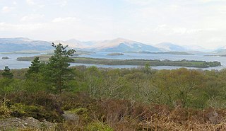
Loch Lomond National Nature Reserve (NNR) encompasses 430 hectares of land at the southeastern part of Loch Lomond in the council areas of Stirling and West Dunbartonshire, in Scotland. It covers the islands of Inchcailloch, Clairinsh, Torrinch, Creinch and Aber Isle, alongside areas of woodland and wetlands to either side of the mouth of the Endrick Water. NatureScot owns two parts of the reserve - the island of Inchcailloch and part of Gartfairn Wood - and the rest is privately owned. The reserve is managed by a partnership consisting of NatureScot, the RSPB Scotland and the Loch Lomond and The Trossachs National Park, along with the owners and tenants of the land under agreements. Within this framework NatureScot directly manage the islands of Clairinsh, Inchcailloch, Torrinch and Creinch, and land to the north of the Endrick Water. The RSPB manages the area to the south of the Endrick Water, and the National Park manages visitor facilities on Inchcailloch.


