
Barra is an island in the Outer Hebrides, Scotland, and the second southernmost inhabited island there, after the adjacent island of Vatersay to which it is connected by a short causeway. The island is named after Saint Finbarr of Cork.

The island of Vatersay is the southernmost and westernmost inhabited island in the Outer Hebrides of Scotland, and the settlement of Caolas on the north coast of the island is the westernmost permanently inhabited place in Scotland. The main village, also called Vatersay, is in the south of the island.
Mingulay is the second largest of the Bishop's Isles in the Outer Hebrides of Scotland. Located 12 nautical miles south of Barra, it is known for its important seabird populations, including puffins, black-legged kittiwakes, and razorbills, which nest in the sea-cliffs, amongst the highest in the British Isles.
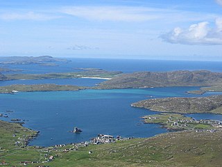
The Barra Isles, also known as the Bishop's Isles, are a small archipelago in the Outer Hebrides of Scotland. They lie south of the island of Barra, for which they are named. The group consists of nine islands and numerous rocky islets, skerries, and sea stacks.
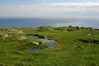
Barra Head, also known as Berneray, is the southernmost island of the Outer Hebrides in Scotland. Within the Outer Hebrides, it forms part of the Barra Isles archipelago. Originally, Barra Head only referred to the southernmost headland of Berneray but is now a common name for the entire island. The highest point of the island is Sotan, a Marilyn.

The River Irthing is a river in Cumbria, England and a major tributary of the River Eden. The name is recorded as Ard or Arden in early references. For the first 15 miles of its course it defines the border between Northumberland and Cumbria.

The First Battle of Fort Fisher was a naval siege in the American Civil War, when the Union tried to capture the fort guarding Wilmington, North Carolina, the South's last major Atlantic port. Led by Major General Benjamin Butler, it lasted from December 24–27, 1864.

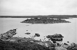
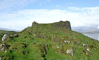
Lingeigh or Lingay is an unpopulated islet in the Outer Hebrides. It lies towards the southern end of the archipelago, just north of Rosinish and five kilometres south of Vatersay. There is a cave on the southeast side of the island.
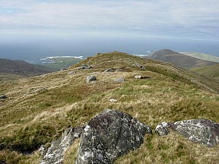
Heaval is the highest hill on the Outer Hebridean island of Barra, Scotland. The highest point is 383 metres high above sea level and it is located 1.5 km northeast of Castlebay.

Maiden Castle is an Iron Age hill fort, one of many fortified hill-top settlements constructed across Britain during the Iron Age, but one of only seven in the county of Cheshire in northern England. The hill fort was probably occupied from its construction in 600 BC until the Roman conquest of Britain in the 1st century AD. At this time the Cornovii tribe are recorded to have occupied parts of the surrounding area but, because they left no distinctive pottery or metalworking, their occupation has not been verified. Since then it has been quarried and used for military exercises. It is protected as a Scheduled Ancient Monument, and is owned by the National Trust. The hill fort is open to visitors, but unrestricted access to the site has resulted in it being classified as "at high risk" from erosion.
Dùn Anlaimh, also known as Dùn Amhlaidh, and Eilean nan Cinneachan, is a crannog, located within Loch nan Cinneachan on the Inner Hebridean island of Coll. Upon the crannog there are the remains of walls and several buildings. These remains are not unlike those of other fortified islands found throughout the Outer Hebrides, and it is likely that Dùn Anlaimh dates from the late Middle Ages. According to local tradition on Coll, the fort was once the home of a Norse chieftain who was defeated in battle somewhere nearby. The early 20th century antiquary Erskine Beveridge considered it as one of the four most interesting fortifications, on Coll. The site of Dùn Anlaimh is located at grid reference NM18845684. The RCAHMS classifies the site as a 'crannog' and an 'island dwelling'.
Isle of Barra distillery at Borve, Barra, Scotland is a planned future whisky distillery on Barra. The Barra Distillery company was founded in 2003 but the distillery buildings are still to be constructed. However, wind turbines to power the distillery were installed in 2012 The distillery has become a Community Benefit Society, a vehicle to direct profits to support social and economic development in the community of Barra & Vatersay via a charitable trust. Shares are available to purchase, and it is expected that construction will commence before 2022.

Dùn Dubh is a hillfort, located on the Inner Hebridean island of Coll. The fort is one of three associated with a local tradition which states that they were once the fortresses of Norsemen before being defeated by a Maclean chieftain. The early 20th century antiquary Erskine Beveridge considered it as one of the four most interesting fortifications, on Coll. The site is located at grid reference NM18365942.

Dùn Beic is a dun located on the Inner Hebridean island of Coll. It is located at grid reference NM15495644 and is thought to date to between 1000 BCE to 1000 CE. The etymology of the dun's name is uncertain; one possibility is that it could be made up of a personal name. The dun appears in local legend as being one of several fortresses held by Norsemen, who were defeated in battle against the ancestor of the Macleans of Coll. There have been several archaeological finds at Dùn Beic; these include pieces of flint, burnt bone, and fragments of incised pottery.
An Caisteal is a hill fort located on the island of Coll. This island is one of the islands which make up the Inner Hebrides located on the west coast of Scotland. The fort is located at grid reference NM17185815. Located 1,200 yards (1.1 km) to the north-east of An Caisteal is Dùn Foulag. Dùn Foulag, located at grid reference NM17505908, was once thought to be a dun, though it is now considered to be only a naturally rocky knoll.

Fort Heath was a US seacoast military installation for defense of the Boston and Winthrop Harbors with an early 20th-century Coast Artillery fort, a 1930s USCG radio station, prewar naval research facilities, World War II batteries, and a Cold War radar station. The fort was part of the Harbor Defenses of Boston and was garrisoned by the United States Army Coast Artillery Corps. The fort's military structures have been replaced by a residential complex, including the luxurious Forth Heath Apartments, and recreation facilities of Small Park, which has both a commemorative wall and an historical marker for Fort Heath.
Bearasaigh or Bearasay is an islet in outer Loch Ròg, Lewis, Scotland. During the late 16th and early 17th centuries it was used as a pirates' hideout and the remains of various buildings from that period still exist. In the modern era its cliffs are used for rock-climbing.
Tirefour Castle, is an Iron Age broch located 4 kilometres north of Achnacroish on the island of Lismore, Scotland.

The Bulwarks, Porthkerry is a promontory fort in Rhoose, Vale of Glamorgan, on the southern coast of Wales overlooking the Bristol Channel. It probably dates to the Iron Age and continued to be occupied during the Roman period in Britain. The ramparts and ditches along the west side are well preserved, but the fortifications are heavily overgrown.
