The economy of Nepal is developing category and largely dependent on agriculture and remittances. An isolated, industrial society until the mid-20th century, Nepal entered the modern era in 1951 without schools, hospitals, roads, telecommunications, electric power, industry, or civil service. The country has, however, made progress toward sustainable economic growth since the 1950s. The country was opened to economic liberalization, leading to economic growth and improvement in living standards when compared to the past. The biggest challenges faced by the country in achieving higher economic development are the frequent changes in political leadership, as well as corruption.

Nepal is a landlocked country in South Asia. It is mainly situated in the Himalayas, but also includes parts of the Indo-Gangetic Plain. It borders the Tibet Autonomous Region of China to the north, and India in the south, east, and west, while it is narrowly separated from Bangladesh by the Siliguri Corridor, and from Bhutan by the Indian state of Sikkim. Nepal has a diverse geography, including fertile plains, subalpine forested hills, and eight of the world's ten tallest mountains, including Mount Everest, the highest point on Earth. Kathmandu is the nation's capital and the largest city. Nepal is a multi-ethnic, multi-lingual, multi-religious and multi-cultural state, with Nepali as the official language.

The Communist Party of Nepal (Unified Marxist–Leninist) (Nepali: नेपाल कम्युनिष्ट पार्टी (एकीकृत मार्क्सवादी-लेनिनवादी), romanized: nēpāla kamyuniṣṭa pārṭī (ēkīkr̥ta mārksavādī-lēninavādī); abbr. CPN (UML)) is a communist political party in Nepal. The party emerged as one of the major party in Nepal after the end of the Panchayat era.

Momos are a type of steamed filled dumpling in Tibetan and Nepali cuisine that is also popular in neighbouring Bhutan and India. Momos are usually served with a sauce known as achar influenced by the spices and herbs used within many South Asian cuisines. It can also be cooked as soup versions known as jhol momo where the broth is made from achar using a mixture of tomatoes, sesame seeds, chillies, cumin and coriander or mokthuk from boiling pork/buffalo bones mixed with various herbs and vegetables.
Buddhism in Nepal started spreading since the reign of Ashoka through Indian and Tibetan missionaries. The Kiratas were the first people in Nepal who embraced Gautama Buddha’s teachings, followed by the Licchavis and Newar people. Buddha was born in Lumbini in the Shakya Kingdom. Lumbini is considered to lie in present-day Rupandehi District, Lumbini zone of Nepal. Buddhism is the second-largest religion in Nepal. According to 2001 census, 10.74% of Nepal's population practiced Buddhism, consisting mainly of Tibeto-Burman-speaking ethnicities and the Newar. However, in the 2011 census, Buddhists made up just 9% of the country's population.

Madhubani district is one of the thirty-eight districts of Bihar, India, and is a part of Darbhanga division. Its administrative headquarters are located in Madhubani. The district has an area of 3,501 square kilometres (1,352 sq mi) and has a population of 4,487,379.
Ramechhap District, a part of Bagmati Province, is a district of Nepal. The district, also known as Wallo Kirat Ramechhap, has its district headquarters in Manthali and covers an area of 1,546 km2 (597 sq mi). It had a population of 202,646 in 2011. and population density of 137.4 per km2. It has 11 post offices, with the District Post Office (D.P.O.) bearing the postal code 45400.

The administrative divisions of Nepal are subnational administrative units of Nepal. The first level of country subdivision of Nepal are the provinces. Each province is further subdivided into districts, each district into municipalities and rural municipalities, and each of those municipalities into wards. Before 2015, instead of provinces, Nepal was divided into developmental regions and administrative zones.

Religion in Nepal encompasses a wide diversity of groups and beliefs. Nepal is a secular nation, and secularism in Nepal under the interim constitution is defined as "religious and cultural freedom, along with the protection of religion and culture handed down from time immemorial." That is, "the state government is bound for protecting and fostering Hindu religion" while maintaining "religious" and "cultural" freedom throughout the nation as fundamental rights.

The Catholic Church in Nepal is part of the worldwide Catholic Church, under the spiritual leadership of the Pope in Rome. As of 2011 there are over 10,000 Catholics in Nepal, organized into one Catholic jurisdiction known as an apostolic vicariate.
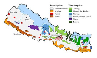
Ethnic groups in Nepal are delineated using language, ethnic identity or the caste system in Nepal. They are categorized by common culture and endogamy. Endogamy carves out ethnic groups in Nepal.
It is estimated that in the Middle East, over 900,000 people profess Buddhism as their religion. Buddhist adherents make up just over 0.3% of the Middle East total population. Many of these Buddhists are workers who have migrated from Asia to the Middle East since the late 1990s, many of them come from countries that have large Buddhist populations, such as China, Vietnam, Thailand, Sri Lanka, and Nepal.

Overseas Indians, officially Non-Resident Indians (NRIs) and People of Indian Origin (PIOs) are Indians who reside or originate outside of India. According to the Government of India, Non-Resident Indians are citizens of India who currently are not living in India, while the term People of Indian Origin refers to people of Indian birth or ancestry who are citizens of countries other than India. Overseas Citizenship of India (OCI) is given to People of Indian Origin and to persons who are not People of Indian Origin but married to People of Indian Origin. Persons with OCI status are known as Overseas Citizens of India (OCIs). The OCI status is a permanent visa for visiting India with a foreign passport.
Kandu or Kanu( Halwai) is a social group or caste that belongs to the Vaishya Varna of the Hindu religion. The community is also referred to as Madheshia Vaishya. They are also identified with the term Bania, representing a community that has been historically associated with sweet-making, smaller trading activities, business, shop-keeping, grain-parching etc. in the eastern parts of India.
Nepal conducted a widespread national census in 2011 by the Nepal Central Bureau of Statistics. Working with the 58 municipalities and the 3915 Village Development Committees at a district level, they recorded data from all the municipalities and villages of each district. The data included statistics on population size, households, sex and age distribution, place of birth, residence characteristics, literacy, marital status, religion, language spoken, caste/ethnic group, economically active population, education, number of children, employment status, and occupation.

Koshi Province is the autonomous easternmost province adopted on 20 September 2015 by Constitution of Nepal. The province is rich in natural resources, tourist attractions, recreational activities, and natural beauty. The province covers an area of 25,905 km2, about 17.5% of the country's total area. With the industrial city of Biratnagar as its capital, the province covers other major eastern towns including Birtamod, Birat Chowk, Damak, Dharan, Itahari, Triyuga and Mechinagar and includes several mountains including the Everest, Kangchenjunga, and Ama Dablam. Koshi River, the largest river of the nation, is the province's western boundary. Understanding of the first-past-the-post voting system issued by the Constituency Delimitation Commission, Nepal, the province hosts 28 parliamentary seats and 56 provincial assembly seats.

Karnali Province is one of the seven federal provinces of Nepal formed by the new constitution which was adopted on 20 September 2015. The total area of the province is 27,984 square kilometres (10,805 sq mi) covering 18.97% of the country, making it the largest province in Nepal. According to the 2011 Nepal census, the population of the province was 1,570,418, making it the least populous province in Nepal. It borders the Tibet Autonomous Region of China to the north, Gandaki Province to the east, Sudurpashchim Province to the west, and Lumbini Province to the south. Birendranagar with a population of 154,886 is both the province's capital and largest city.
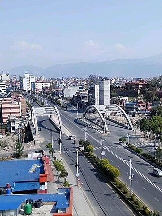
The COVID-19 pandemic in Nepal is part of the worldwide pandemic of coronavirus disease 2019 caused by severe acute respiratory syndrome coronavirus 2. The first case in Nepal was confirmed on 23 January 2020 when a 31-year-old student, who had returned to Kathmandu from Wuhan on 9 January, tested positive for the disease. It was also the first recorded case of COVID-19 in South Asia. Nepal's first case of local transmission was confirmed on 4 April in Kailali District. The first death occurred on 14 May. A country-wide lockdown came into effect on 24 March 2020, and ended on 21 July 2020. As of 26 July 2022, the Ministry of Health and Population (MoHP) has confirmed a total of 984,475 cases, 968,802 recoveries, and 11,959 deaths in the country. In the meantime, 5,804,358 real-time RT-PCR (RT-qPCR) tests have been performed in 40 laboratories across the country. The viral disease has been detected in all provinces and districts of the country, with Bagmati Province and Kathmandu being the worst hit province and district respectively. As for Nepalese abroad, as of 26 July 2020, the Non-Resident Nepali Association has reported a total of 12,667 confirmed cases, 16,190 recoveries, and 161 deaths across 35 countries.

