Related Research Articles

The Lillooet River is a major river of the southern Coast Mountains of British Columbia. It begins at Silt Lake, on the southern edge of the Lillooet Crown Icecap about 80 kilometres northwest of Pemberton and about 85 kilometres northwest of Whistler. Its upper valley is about 95 kilometres in length, entering Lillooet Lake about 15 km downstream from Pemberton on the eastern outskirts of the Mount Currie reserve of the Lil'wat branch of the St'at'imc people. From Pemberton Meadows, about 40 km upstream from Pemberton, to Lillooet Lake, the flat bottomlands of the river form the Pemberton Valley farming region.

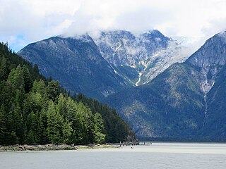
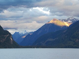
Lillooet Lake is a lake in British Columbia, Canada about 25 km in length and about 33.5 square kilometres (22 mi²) in area. It is about 95 km downstream from the source of the Lillooet River, which resumes its course after leaving Little Lillooet Lake, aka Tenas Lake. Immediately adjacent to the mouth of the upper Lillooet River is the mouth of the Birkenhead River and just upstream along the Lillooet is the confluence of the Green River, which begins at Green Lake in the resort area of Whistler.

The Lillooet Ranges are the southeasternmost subdivision of the Pacific Ranges of the Coast Mountains of British Columbia. They are located between the drainage of the Lillooet River and Harrison Lake on the west and the canyon of the Fraser River on the east, and by the lowland coastal valley of that river on the south.

The Pacific Ranges are the southernmost subdivision of the Coast Mountains portion of the Pacific Cordillera. Located entirely within British Columbia, Canada, they run northwest from the lower stretches of the Fraser River to Bella Coola and Burke Channel, north of which are the Kitimat Ranges. The Coast Mountains lie between the Interior Plateau and the Coast of British Columbia.

The Shulaps Range is a subrange of the Chilcotin Ranges subset of the Pacific Ranges of the Coast Mountains in southwest-central British Columbia. The range is 55 km NW–SE and 15 km SW–NE and 2,970 km2 (1,150 sq mi) in area.
Mount Raleigh, elevation 3,132 m (10,276 ft), is one of the principal summits of the Pacific Ranges of the Coast Mountains of southern British Columbia in Canada. It is located just southeast of the confluence of the Southgate and Bishop Rivers, northeast of the head of Bute Inlet, and is the highest summit south of the Bishop River's divide with the Lillooet River at Ring Pass, which is at the southeastern edge of the Lillooet Icefield and just north of the Pemberton Icecap. It is also the highest peak south of the pass between the upper basins of Chilko Lake and the Taseko Lakes, just north of which is Monmouth Mountain at 3,182 m (10,440 ft).

Monmouth Mountain, commonly known as Mount Monmouth is one of the principal summits of the Pacific Ranges of the Coast Mountains of southern British Columbia. At 3,182 m (10,440 ft), it is the highest summit of the Chilcotin Ranges. It stands just north of the Lillooet Icecap between the heads of Chilko Lake and the Taseko Lakes. West of Chilko Lake's south arm is Mount Good Hope 3,242 m (10,636 ft) and, beyond it, the massif surrounding Mount Queen Bess 3,298 m (10,820 ft), which is the highest summit east of the Homathko River.

The Camelsfoot Range is a sub-range of the Chilcotin Ranges subdivision of the Pacific Ranges of the Coast Mountains in British Columbia. The Fraser River forms its eastern boundary. The range is approximately 90 km at its maximum length and less than 30 km wide at its widest.
Bishop River Provincial Park is a provincial park in the Pacific Ranges of the Coast Mountains on the Mainland of British Columbia, Canada, located southwest of and adjoining Ts'yl-os Provincial Park."Bishop River Park". BC Geographical Names. It lies along the upper course of the Bishop River, the main tributary of the Southgate River, from the Bishop's source at the western side of the Lillooet Icecap to midway along its course above its confluence with the Southgate. The park is 19,947 ha. in size. There are no roads or trails in the park although a forest service road from Waddington Harbour at the head of Bute Inlet leads up the Southgate to within a few miles of the park boundary.
Homathko Estuary Provincial Park is a provincial park in British Columbia, Canada, located at the head of Bute Inlet surrounding the mouth of the Homathko River in the Pacific Ranges of the Coast Mountains.
The Lillooet Icecap, also called the Lillooet Icefield or the Lillooet Crown, is a large icefield in the Pacific Ranges of the Coast Mountains in southwestern British Columbia, Canada. It is about 90 km (56 mi) northwest of the towns of Pemberton and Whistler, and about 175 km (109 mi) north of Vancouver, British Columbia. The Lillooet Icecap is one of the largest of several large icefields in the Pacific Ranges which are the largest temperate-latitude glacial fields in the world. At its maximum extent including its glacial tongues it measures 30 km (19 mi) east to west and 20 km (12 mi) north to south; its central icefield area is approximately 15 km (9 mi) in diameter.

The Homathko Icefield is an icefield in British Columbia, Canada. Officially named the Homathko Snowfield from 1950 until the current name was adopted in 1976, it is one of the largest icefields in the southern half of the Coast Mountains, with an area of over 2,000 km2 (770 sq mi). It is located between Chilko Lake and the Homathko River, and lies across the Great Canyon of that river to the east of the Waddington Range. Although adjacent to Mount Queen Bess, the Homathko Icefield is largely an expanse of ice, about 30 km (19 mi) across, ringed by relatively minor peaks and distinguished, relative to the other Coast Mountains icefields, by lack of any major ones. The Lillooet Icecap and the Compton Névé, both similar in size to the Homathko Icefield but much more peak-studded, lie to the Homathko Icefield's southeast across the Southgate River which bends around the icefield-massif's southern flank to reach the head of Bute Inlet adjacent to the mouth of the Homathko River. The icefield is essentially one large ice-girt montane plateau between these two rivers.
Cayoosh Pass is a mountain pass in the Lillooet Ranges of the Pacific Ranges of the southern Coast Mountains in British Columbia, Canada. It lies just west of Duffey Lake on BC Highway 99 between the towns of Lillooet and Pemberton, formed by the headwaters of Cayoosh Creek to the east, flowing to the Fraser River at Lillooet, and Joffre Creek to the west, flowing steeply downhill to Lillooet Lake just southeast of the Mount Currie Indian Reserve.
The Compton Névé is a névé in the Pacific Ranges of the Coast Mountains in southwestern British Columbia, Canada, located southeast of the Homathko Icefield and Mount Gilbert and to the south of the Bishop River. It lies west of the Lillooet Icecap and is connected to it by the Ring Glacier, which sits astride Ring Pass, the divide between the Lillooet and Bishop Rivers, and has an area of 714 km2 (276 sq mi).
The Southgate River is a river in the Pacific Ranges of the Coast Mountains in British Columbia, Canada, entering the head of Bute Inlet, on that province's South Coast, just east of the mouth of the Homathko River at Waddington Harbour. The lower reaches of the river's course are flat-bottomed and are named Pigeon Valley.
Mount Gilbert, 3124 m prominence: 484 m, is a mountain in the Pacific Ranges of the Coast Mountains of British Columbia, Canada. It is located south of the confluence of the Bishop and Southgate Rivers and to the west of the Compton Névé, a large icefield, and to the south of the Homathko Icefield, another large icefield.
The Lillooet Land District is one of the 59 cadastral subdivisions of British Columbia, which were created by the Lands Act of the Colony of British Columbia in 1859, defined as "a territorial division with legally defined boundaries for administrative purposes". The land district's boundaries came to be used as the boundary of the initial Lillooet riding for the provincial Legislature from 1871, when the colony became a province. In addition to use in descriptions of land titles and lot surveys, the Land District was also the basis of the Lillooet Mining District.
Waddington Harbour is a harbour at the head of Bute Inlet in the Central Coast region of British Columbia, Canada. Also issuing into the head of Bute Inlet and Waddington Harbour, just east of the mouth of the Homathko, is the Teaquahan River. Issuing directly into the inlet a few miles south on the harbour's southeast is the Southgate River, one of the major rivers of the central Pacific Ranges, which begins on the west side of the Lillooet Icecap. Its lower valley adjacent to the inlet's shores is called Pigeon Valley.
The Teaquahan River, formerly Teaquahan Creek, is a river in the Pacific Ranges of the Coast Mountains, flowing into the head of Bute Inlet at Waddington Harbour, immediately east of the mouth of the Homathko River.
Mosely Creek is a large creek in the Pacific Ranges of the Coast Mountains in British Columbia, Canada, flowing southwest to join the Homathko River in its canyon downstream from Tatlayoko Lake, and a short distance above Murderers Bar at 51°16′00″N124°54′00″W, which is the site of the opening events of the Chilcotin War of 1864.
References
50°58′36″N124°21′36″W / 50.97667°N 124.36000°W
| | This article about a river in the Coast of British Columbia, Canada is a stub. You can help Wikipedia by expanding it. |