
Parmer County is a county located in the southwestern Texas Panhandle on the high plains of the Llano Estacado in the U.S. state of Texas. As of the 2010 census, the population was 10,269. The county seat is Farwell. The county was created in 1876 and later organized in 1907. It is named in honor of Martin Parmer, a signer of the Texas Declaration of Independence and early judge. Parmer County was one of 10 prohibition, or entirely dry, counties in the state of Texas, but is now a wet county.

Motley County is a county located in the U.S. state of Texas. As of the 2010 census, its population was 1,210, making it the 10th-least populous county in Texas. Its county seat is Matador. The county was created in 1876 and organized in 1891. It is named for Junius William Mottley, a signer of the Texas Declaration of Independence. Mottley's name is spelled incorrectly because the bill establishing the county misspelled his name. Motley County was one of 30 prohibition, or entirely dry, counties in Texas, but is now a wet county.
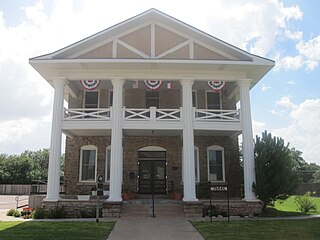
Post is a city in and the county seat of Garza County, Texas, United States. The population was 5,376 at the 2010 census.
Farwell is a city in and the county seat of Parmer County, Texas, United States. The population was 1363 at the 2010 census. The city is located on the Texas-New Mexico border with the city of Texico, New Mexico across the border.

Hungerford is a census-designated place (CDP) in northeastern Wharton County, Texas, United States. U.S. Route 59, Texas State Highway 60, and Farm to Market Road 1161 intersect in the community. The Union Pacific Railroad passes through Hungerford. The population was 347 at the 2010 census. It is located on what in the 1820s was the Alexander Jackson league. By the 1870s, the Quinan settlement grew up a short distance away, but its residents moved to the new town when the railroad came through Hungerford.

Garden City is an unincorporated community and census-designated place (CDP) in Glasscock County, Texas, United States. It lies near the center of the county, 27 miles (43 km) south of Big Spring. Garden City serves as the Glasscock County seat, and at the 2010 census had a population of 334. The ZIP code is 79739.
Lazbuddie is an unincorporated community in Parmer County, Texas, United States. Named for local business owner, Luther "Laz" Green, and his partner, Andrew "Buddie" Sherley, the community grew up around the store they opened in 1924. Later a post office and school were established. The town has two cotton gins, a grain elevator, a hardware store, and several churches. The community's focal point is the Lazbuddie Independent School District which educates children from the surrounding rural area. Six-man football is played at Lazbuddie High School. On May 10, 1991, 3 tornadoes hit the ground in Lazbuddie and the event was caught on camera by farmers. Lazbuddie used to be spelt with a y but the post office made a mistake and it is now spelt how it is.
Red River Station is a ghost town south of the Red River at Salt Creek in northwestern Montague County, Texas, United States.

Juno is a small unincorporated community in Val Verde County, Texas, United States, in the southwestern part of the state.

Texon is a small unincorporated town in Reagan County, Texas, United States, in the western part of the state. The town is noted for its boom as an oil town and subsequent near abandonment.

Southland is an unincorporated community in Garza County, Texas, United States. It lies along the eastern edge of the Llano Estacado on U.S. Route 84, twenty miles northwest of Post.
Mabelle is an unincorporated community in Baylor County, Texas, United States. Its elevation is 1,289 feet (393 m). The community lies at the intersection of U.S. Routes 82, 183, 277, 283, and Farm to Market Road 1790, 9 miles northeast of the city of Seymour, the county seat of Baylor County.

Crabb is a small unincorporated community in Fort Bend County, Texas, United States. Crabb is located along Farm to Market Road 762 and the BNSF Railroad southeast of Richmond, Texas. The Crabb road sign is located west of the intersection of Crabb River Road and Farm to Market Road 2759 and FM 762. The Zion Hill Baptist Church, a Fort Bend County Road and Bridge facility, the Brazos Village and Brazos Gardens subdivisions, several businesses and an abandoned grain elevator are in the area.
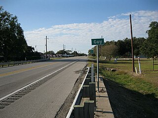
Guy is an unincorporated community in Fort Bend County, Texas, United States. It is located on Texas State Highway 36 (SH 36) about 16 miles (26 km) south of Rosenberg, Texas. A trucking company, a Shell Oil Company filling station, a post office, and several homes are located near the intersection of SH 36 and Farm to Market Road 1994 (FM 1994). The community was established in 1890 and was served by a railroad between 1918 and the 1980s.
Flomot is an unincorporated community in Motley County, Texas, United States. According to the Handbook of Texas, the community had an estimated population of 181 in 2000.

Chesterville is an unincorporated community in eastern Colorado County, in the U.S. state of Texas. It is located in a farming region northeast of Eagle Lake at the junction of Farm to Market Road 1093 (FM 1093) and Farm to Market Road 2764 (FM 2764). A large grain storage facility is a significant landmark in the area.

Cuthbert is a ghost town in Mitchell County, Texas, United States. Cuthbert was established in 1890 when the founder D. T. Bozeman built a wagonyard and store. The community and post office were named for Thomas Cuthbertson, a family friend of the Bozemans. By the early 1920s, Cuthbert had a church, two stores, a blacksmith shop, a cotton gin, telephone office, and a school.In 1920 the T. and P. Abrams No. 1 oil well, one of the first commercial oil ventures in the Permian Basin, was drilled just over a mile north of the town. A post office, two businesses, and a population of twenty-five were reported at the community in 1936, the year that its school was consolidated with that of Colorado City. After World War II the improvement of rural roads in the area led to Cuthbert's decline as it lost its trade to Colorado City. The Cuthbert post office was discontinued about 1960, when the town reported one business and a population of twenty-five. By 1974 only a cemetery and scattered farms remained in the area.

Whiteflat is a ghost town in Motley County, Texas, United States. The population was estimated to be 3 at the 2000 census.
Parmerton is a ghost town in Parmer County, Texas. It was originally know as Parmer Switch when the Pecos Valley and Northern Texas Railway built a line through the area in 1898 and it was named for Martin Parmer. The town was composed of 200 acres of land formerly owned by the XIT Ranch and had been used for wheat farming. A one-story courthouse was built at the midway point between Bovina and Friona and a post office was established in September 1907, shortly after Parmerton was voted Parmer County seat. After significant political intrigue, a second election was held in December 1907, after which Parmerton was stripped it its status in favor of Farwell. The post office closed in 1908 and Parmerton went into decline; today nothing remains except for an historical marker and a railroad switch.
La Plata is a ghost town in Deaf Smith County, Texas. It was originally named Grenada and was established in 1890 by the XIT Ranch as a means of consolidating political power after Deaf Smith County was established. The town engaged in a controversial battle with neighboring Ayr over the county seat election, which was mired in corruption. After winning the election, county judge J. R. Dean changed the town's name to La Plata due to a request from postal officials. A courthouse was built and the town soon added a post office, a school, a county jail, and a Presbyterian church. Businesses included a general store, a pharmacy, a saloon, a hotel, an implement house, a blacksmith shop, a livery stable, and the offices which housed the county's first newspaper, the La Plata Star.


