Black Butte (Glenn County, California)

Last updated
Black Butte
Relief map of California.png
Red triangle with thick white border.svg
Black Butte
Highest point
Elevation 7,455 ft (2,272 m)  NAVD 88 [1]
Prominence 2,436 ft (742 m) [2]
Listing California county high points 27th
Coordinates 39°43′36″N122°52′21″W / 39.726746503°N 122.872421264°W / 39.726746503; -122.872421264 Coordinates: 39°43′36″N122°52′21″W / 39.726746503°N 122.872421264°W / 39.726746503; -122.872421264 [1]
Geography
Location Glenn County, California, U.S.
Parent range Central Northern California Coast Range
Topo map USGS Plaskett Meadows

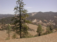
Black Butte is a mountain butte located in the Northern Coast Ranges of California south of Mendocino Pass. It rises to an elevation of 7,455 feet (2,272 m) north of the Black Butte River.

Mountain A large landform that rises fairly steeply above the surrounding land over a limited area

A mountain is a large landform that rises above the surrounding land in a limited area, usually in the form of a peak. A mountain is generally steeper than a hill. Mountains are formed through tectonic forces or volcanism. These forces can locally raise the surface of the earth. Mountains erode slowly through the action of rivers, weather conditions, and glaciers. A few mountains are isolated summits, but most occur in huge mountain ranges.

Butte Isolated hill with steep, often vertical sides and a small, relatively flat top

In geomorphology, a butte is an isolated hill with steep, often vertical sides and a small, relatively flat top; buttes are smaller landforms than mesas, plateaus, and tablelands. The word "butte" comes from a French word meaning "small hill"; its use is prevalent in the Western United States, including the southwest where "mesa" is used for the larger landform. Because of their distinctive shapes, buttes are frequently landmarks in plains and mountainous areas. In differentiating mesas and buttes, geographers use the rule of thumb that a mesa has a top that is wider than its height, while a butte has a top that is narrower than its height.

California State of the United States of America

California is a state in the Pacific Region of the United States. With 39.6 million residents, California is the most populous U.S. state and the third-largest by area. The state capital is Sacramento. The Greater Los Angeles Area and the San Francisco Bay Area are the nation's second and fifth most populous urban regions, with 18.7 million and 8.8 million residents respectively. Los Angeles is California's most populous city, and the country's second most populous, after New York City. California also has the nation's most populous county, Los Angeles County, and its largest county by area, San Bernardino County. The City and County of San Francisco is both the country's second-most densely populated major city after New York City and the fifth-most densely populated county, behind only four of the five New York City boroughs.

Contents

The mountain on the Mendocino National Forest is the highest point in county of Glenn County. In spite of the difference in elevation between the river valley at 2,800 feet (850 m) and Black Butte, the summit's prominence is moderate due the neighboring 6,500-foot (1,980 m) Plaskett Meadows. [3] The high elevation of the mountain and plateau bring heavy winter snowfall and a low average annual temperature. [4] US Forest Highway 7, a dirt road connection between the eastern and western segments of State Route 162 passes to the north of Black Butte. However, this route is closed in winter due to heavy snowfall.

Mendocino National Forest

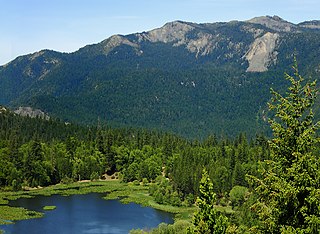
The Mendocino National Forest is located in the Coastal Mountain Range in northwestern California and comprises 913,306 acres (3,696 km2). It is the only national forest in the state of California without a major paved road entering it. There are a variety of recreational opportunities — camping, hiking, mountain biking, paragliding, backpacking, boating, fishing, hunting, nature study, photography, and off-highway vehicle travel.

California State Route 162 highway in California

State Route 162 runs roughly west–east from U.S. Route 101 near Longvale, in Mendocino County, to Oroville, in Butte County. For most of its length, it is a two lane, undivided highway. The highway is broken into two pieces; the state's sponsorship of the road ends where it enters the Mendocino National Forest in Mendocino County where it becomes an unimproved dirt road maintained by the U.S. Forest Service as Forest Highway 7 (FH 7). State Route 162 begins again at the eastern boundary of the National Forest in Glenn County, some 30 miles (48 km) west of Willows.

See also

Related Research Articles

Santa Cruz Mountains mountain range in California, United States

The Santa Cruz Mountains, part of the Pacific Coast Ranges, are a mountain range in central and northern California, United States. They form a ridge down the San Francisco Peninsula, south of San Francisco. They separate the Pacific Ocean from the San Francisco Bay and the Santa Clara Valley, and continue south to the Central Coast, bordering Monterey Bay and ending at the Salinas Valley. The range passes through the counties of San Mateo, Santa Clara, Santa Cruz, San Benito and Monterey, with the Pajaro River forming the southern boundary.

Mount McLoughlin mountain in United States of America

Mount McLoughlin is a steep-sided stratovolcano, or composite volcano, in the Cascade Range of southern Oregon and within the Sky Lakes Wilderness. It is one of the volcanic peaks in the Cascade Volcanic Arc, within the High Cascades sector. A prominent landmark for the Rogue River Valley, the mountain is north of Mount Shasta, and Crater Lake lies to the northwest. It was named around 1838 after John McLoughlin, a Chief Factor for the Hudson's Bay Company. McLouglin's prominence has made it a landmark to Native American populations for thousands of years.

Trinity Alps

The Trinity Alps are a mountain range in Siskiyou County and Trinity County, in Northern California. They are a subrange of the Klamath Mountains and located to the north of Weaverville.

Diablo Range mountain range in California, United States of America

The Diablo Range is a mountain range in the California Coast Ranges subdivision of the Pacific Coast Ranges. It is located in the eastern San Francisco Bay area south to the Salinas Valley area of northern California, the United States.

Shavers Fork Mountain Complex

Shavers Fork Mountain Complex is the name given to the mountains on either side of Shavers Fork in the highlands portions of Randolph County, Pocahontas County, and Tucker County in West Virginia, USA. Much of the land surrounding the river and its adjacent mountains is protected by Monongahela National Forest including about 20,000 acres (81 km2) of designated wilderness.

King Range (California)

The King Range is a mountain range of the Outer Northern California Coast Ranges System, located entirely within Humboldt County on the North Coast of California.

The Mendocino Range is one of several coastal mountain ranges which compose the Pacific Coast Range. This massive range of coastal mountains was formed during a period of coastal orogeny, millions of years ago. The Mendocino Range is a component of the California Coast Ranges of California. The Klamath Range is north of this region, and the Cascade Range runs to the northeast.

Mount Langley mountain in United States of America

Mount Langley is located on the crest of the Sierra Nevada, on the boundary between Inyo and Tulare counties, in eastern California in the southwestern United States. To the east is Owens Valley, and to the west is the Kern River Valley. It is the ninth-highest peak in the state and the seventh-highest in the Sierra. Mount Whitney, the highest peak in the contiguous United States, lies 4.8 miles (7.7 km) to the northwest. Mt. Langley also has the distinction of being the southernmost fourteener in the United States.

Snow Mountain East mountain in United States of America

Snow Mountain is a mountain in Northern California in the Snow Mountain Wilderness of Mendocino National Forest. The highest point on the mountain, known as Snow Mountain East, is the highest point in both Colusa and Lake counties. Snow Mountain West, a subsidiary peak also near the county line, is 0.58 miles (0.93 km) to the southwest at an elevation of 7,043 feet (2,147 m).

Mount Linn mountain in United States of America

Mount Linn, at 8,098 feet (2,468 m), is the easternmost summit of South Yolla Bolly Mountain, and is located in the Yolla Bolly Mountains range of the southern Klamath Mountains System, in Tehama County, northwestern California.

Mendocino Pass

Mendocino Pass is a mountain pass located in the Northern Coast Ranges in California. The pass, in the extreme northwest corner of Glenn County, is at an elevation of about 5,006 feet (1,526 m) and at the gap, two dirt roads intersect. One of them is US Forest Highway 7, a dirt road connecting two disjointed sections of State Route 162. The pass and dirt roads are closed in winter due to heavy snowfall.

Mount Eddy mountain in United States of America

Mount Eddy is the highest peak of the Trinity Mountains, a mountain range of the Klamath Mountains System, located in Siskiyou County, and Trinity County in northern California.

Anthony Peak mountain in United States of America

Anthony Peak is a mountain located in the Northern Coast Ranges of California north of Mendocino Pass. The summit is the highest point in Mendocino County, and receives snowfall in the winter.

Butte County High Point, California mountain in United States of America

The Butte County High Point is on an unnamed mountain ridge located on the boundary between Butte and Plumas counties in the Sierra Nevada of California.

Double Mountain (California) mountain in United States of America

Double Mountain is the highest point in the Tehachapi Mountains of California. It has two summits of nearly the same elevation. It is south of the town of Tehachapi, Highway 58 and Tehachapi Pass. Due to its elevation, the mountain receives snowfall during the winter.

Snow Mountain Wilderness

The Snow Mountain Wilderness is a 60,076-acre (243.12 km2) federally designated wilderness area located 65 miles (105 km) north of Santa Rosa, California, USA in the Mendocino National Forest. The U.S. Congress passed the California Wilderness Act of 1984 which created 23 new wilderness areas including Snow Mountain. It lies within the North Coast Range of mountains.

Cascades (ecoregion)

The Cascades ecoregion is a Level III ecoregion designated by the United States Environmental Protection Agency (EPA) in the U.S. states of Washington, Oregon, and California. Somewhat smaller than the Cascade mountain range for which it is named, the ecoregion extends north to Snoqualmie Pass, near Seattle, and south to Hayden Pass, near the Oregon-California border, including the peaks and western slopes of most of the High Cascades. A discontiguous section is located on Mount Shasta in California.

The Black Butte River is located in the Mendocino National Forest of northern California in Glenn and Mendocino counties. It is a tributary to the Middle Fork Eel River and flows northward for 24 miles (39 km) from its headwaters near Round Mountain to the confluence with the Middle Fork Eel River. The Northern California Coastal Wild Heritage Wilderness Act of 2006 added 21 miles (34 km) of the Black Butte River to the National Wild and Scenic Rivers System, of which 17.5 miles (28.2 km) are Wild status and 3.5 miles (5.6 km) are Scenic.

Yolla Bolly–Middle Eel Wilderness

The Yolla Bolly–Middle Eel Wilderness is a federally designated wilderness area in the Yolla Bolly Range of the southern Klamath Mountains and the Inner Northern California Coast Ranges, in Northern California.

References

  1. 1 2 "Black Butte". NGS data sheet. U.S. National Geodetic Survey . Retrieved 2009-07-01.
  2. "Black Butte, California". Peakbagger.com. Retrieved 2009-01-25.
  3. Plaskett Meadows quadrangle, California (Map). 1:24000. 7.5 Minute Topographic. USGS . Retrieved 2009-12-14.
  4. "Subsection M261Ba - Eastern Franciscan". USDA, Forest Service. Archived from the original on 2009-01-20. Retrieved 2012-05-02.
Geographic Names Information System geographical database

The Geographic Names Information System (GNIS) is a database that contains name and locative information about more than two million physical and cultural features located throughout the United States of America and its territories. It is a type of gazetteer. GNIS was developed by the United States Geological Survey in cooperation with the United States Board on Geographic Names (BGN) to promote the standardization of feature names.

United States Geological Survey scientific agency of the United States government

The United States Geological Survey is a scientific agency of the United States government. The scientists of the USGS study the landscape of the United States, its natural resources, and the natural hazards that threaten it. The organization has four major science disciplines, concerning biology, geography, geology, and hydrology. The USGS is a fact-finding research organization with no regulatory responsibility.