
The Corporation of Trinity House of Deptford Strond, also known as Trinity House, is the official authority for lighthouses in England, Wales, the Channel Islands and Gibraltar. Trinity House is also responsible for the provision and maintenance of other navigational aids, such as lightvessels, buoys, and maritime radio/satellite communication systems. It is also an official deep sea pilotage authority, providing expert navigators for ships trading in Northern European waters.

The history of the many lightvessel stations of Great Britain goes back over 250 years to the placement of the world's first lightship at the Nore in the early 18th century.
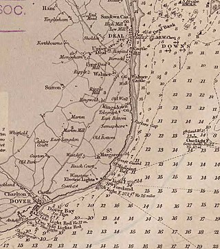
The Downs is a roadstead in the southern North Sea near the English Channel off the east Kent coast, between the North and the South Foreland in southern England. In August 1511, Andrew Barton, a privateer, was killed in battle on board his ship. In 1639 the Battle of the Downs took place here, when the Dutch navy destroyed a Spanish fleet which had sought refuge in neutral English waters. From the Elizabethan era onwards, the presence of the Downs helped to make Deal one of the premier ports in England, and in the 19th century, it was equipped with its own telegraph and timeball tower to enable ships to set their marine chronometers.

The SS Richard Montgomery is a wrecked American Liberty cargo ship that was built during World War II. She was named after Richard Montgomery, an Irish officer who fought in the American Revolutionary War.

The Port of London Authority (PLA) is a self-funding public trust established on 31 March 1909 in accordance with the Port of London Act 1908 to govern the Port of London. Its responsibility extends over the Tideway of the River Thames and its continuation. It maintains and supervises navigation, and protects the river's environment.

Goodwin Sands is a 10-mile-long (16 km) sandbank at the southern end of the North Sea lying 6 miles (10 km) off the Deal coast in Kent, England. The area consists of a layer of approximately 25 m (82 ft) depth of fine sand resting on an Upper Chalk platform belonging to the same geological feature that incorporates the White Cliffs of Dover. The banks lie between 0.5 m above the low water mark to around 3 m (10 ft) below low water, except for one channel that drops to around 20 m (66 ft) below. Tides and currents are constantly shifting the shoals.
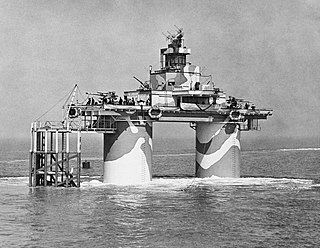
The Maunsell Forts are towers built in the Thames and Mersey estuaries during the Second World War to help defend the United Kingdom. They were operated as army and navy forts, and named for their designer, Guy Maunsell. The forts were decommissioned during the late 1950s and later used for other activities including pirate radio broadcasting. One of the forts is managed by the unrecognised Principality of Sealand; boats visit the remaining forts occasionally, and a consortium named Project Redsands is planning to conserve the fort situated at Red Sands. The aesthetic attraction of the Maunsell forts has been considered to be associated with the aesthetics of decay, transience and nostalgia.

The Thames Estuary is where the River Thames meets the waters of the North Sea, in the south-east of Great Britain.

The Nore is a long bank of sand and silt running along the south-centre of the final narrowing of the Thames Estuary, England. Its south-west is the very narrow Nore Sand. Just short of the Nore's easternmost point where it fades into the channels it has a notable point once marked by a lightship on the line where the estuary of the Thames nominally becomes the North Sea. A lit buoy today stands on this often map-marked divisor: between Havengore Creek in east Essex and Warden Point on the Isle of Sheppey in Kent.
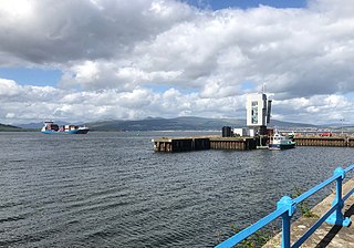
The Tail of the Bank is the name given to the anchorage in the upper Firth of Clyde immediately North of Greenock, between Inverclyde and Argyll and Bute. This area of the Firth gets its name from the deep water immediately to the west of the sandbank which marks the entrance to the navigable channel up the Estuary of the River Clyde.
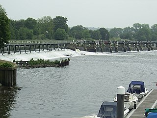
The Tideway is the part of the River Thames in England which is subject to tides. This stretch of water is downstream from Teddington Lock. The Tideway comprises the upper Thames Estuary including the Pool of London.
Fisherman's Gat is a much-deepened channel in the North Sea, between the final long line of shoals loosely associated with the Thames Estuary. The channel cuts across Long Sand. In the west it opens onto the nominal cut-off point of Knock Deep (north) or the Princes Channel (south) which links to the Strait of Dover. In the west it opens to Black Deep, a Thames approach.

The Wyre Light was a 40-foot (12 m) tall iron screw-pile lighthouse marking the navigation channel to the town of Fleetwood, Lancashire, England.

The Doom Bar is a sandbar at the mouth of the estuary of the River Camel, where it meets the Atlantic Ocean on the north coast of Cornwall, England. Like two other permanent sandbanks further up the estuary, the Doom Bar is composed mainly of marine sand that is continually being carried up from the seabed. More than 60 percent of the sand is derived from marine shells, making it an important source of agricultural lime, which has been collected for hundreds of years; an estimated 10 million tons of sand or more has been removed from the estuary since the early nineteenth century, mainly by dredging.
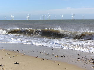
Scroby Sands is a sandbank off the coast of Norfolk, England which runs near shore, north to south from Caister south towards Great Yarmouth. It has been the site of many shipwrecks. Scroby Sands Wind Farm, an offshore 60 MW wind farm, is situated on the sandbank and opened in 2003.
Sandy Hook Pilots are licensed maritime pilots that are members of the Sandy Hook Pilots Association for the Port of New York and New Jersey, the Hudson River, and Long Island Sound. Sandy Hook pilots guide oceangoing vessels, passenger liners, freighters, and tankers in and out of the harbor. The peninsulas of Sandy Hook, and Rockaway in Lower New York Bay define the southern entrance to the port at the Atlantic Ocean.
The Kentish Knock is a long shoal in the North Sea east of Essex, England. It is the most easterly of those of the Thames Estuary and its core, which is shallower than 18 feet (5.5 m), extends 6 miles (9.7 km). Thus it is a major hazard to deep-draught navigation. It is exactly 28 miles (45 km) due east of Foulness Point, Essex and is centred about 15 miles (24 km) NNE of North Foreland, Kent – both are extreme points of those counties.

The Shoeburyness Boom refers to two successive defensive barriers across most of the Thames Estuary in the mid-20th century. As to the part perpendicular to the north shore most of the latter incarnation remains, and its nearest concrete mooring/patrol point 600 metres south. A 2 km stretch, this is designated a scheduled monument and marks the western edge of MoD Shoeburyness firing range, a restricted area. The rest was taken up in the 1960s.

The Swin is a passage in the Thames estuary between Maplin Sands, Foulness Sand and Gunfleet Sand northwest and the Barrow and Sunk sand ridges (shoals), southeast. The Swin was used by barges and leisure craft from the Essex rivers, and coasters and colliers from Hull, Great Grimsby, North East England, Edinburgh and other similar sets of trading ports.
The Edinburgh Channels, formerly a single channel known as the Bullock Channel and then the Duke of Edinburgh Channel are two roughly parallel transverse channels in the Thames Estuary. They used to be important for navigation, providing a deep approach to the River Thames from the south-east through the sandbanks of the estuary. The opening of an alternative channel in 2000 has greatly reduced their use, but having been surveyed and studied extensively over the past two centuries they provide an important example of the processes that shape shallow water landforms.
