Black River (Duwamish River)

Last updated
Pre-1916 and current courses of the Black River Black River pre-1916 and 2013 map.png
Pre-1916 and current courses of the Black River
Maps showing the changes of course and nomenclature of rivers in the Duwamish Valley, 1899-1959. Duwamishvalley1899-1959.png
Maps showing the changes of course and nomenclature of rivers in the Duwamish Valley, 1899-1959.

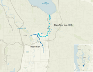
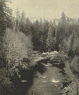
The Black River is a tributary of the Duwamish River in King County in the U.S. state of Washington. It drained Lake Washington until 1916, when the opening of the Lake Washington Ship Canal lowered the lake, causing part of the Black River to dry up. It still exists as a dammed stream about 2 miles (3.2 km) long. [1]

Tributary stream or river that flows into a main stem river or lake

A tributary or affluent is a stream or river that flows into a larger stream or main stem river or a lake. A tributary does not flow directly into a sea or ocean. Tributaries and the main stem river drain the surrounding drainage basin of its surface water and groundwater, leading the water out into an ocean.

Duwamish River name of the lower 12 miles (19 km) of Washington states Green River

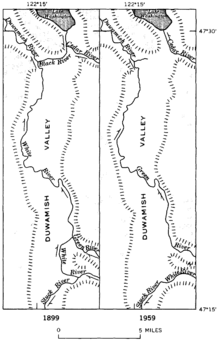
The Duwamish River is the name of the lower 12 miles (19 km) of Washington state's Green River. Its industrialized estuary is known as the Duwamish Waterway.

King County, Washington County in the United States

King County is a county located in the U.S. state of Washington. The population was 2,188,649 in the 2017 census estimate. King is the most populous county in Washington, and the 13th-most populous in the United States. The county seat is Seattle, which is the state's largest city.

Contents

Before the 20th century, Lake Washington emptied from its south end into the Black River, which was joined by the Cedar River before meeting the White River (now the lower Green River; the White River has been diverted south). The confluence of the Black and White rivers created the Duwamish River, which emptied into Elliott Bay in Puget Sound. Thus, the water of rivers emptying into Lake Washington, such as the Sammamish River, once flowed through the Black and Duwamish rivers. Today, Lake Washington's water empties into Puget Sound via the Lake Washington Ship Canal. [2]

Cedar River (Washington) river in the United States of America

The Cedar River is a river in the U.S. state of Washington. About 45 miles (72 km) long, it originates in the Cascade Range and flows generally west and northwest, emptying into the southern end of Lake Washington. Its upper watershed is a protected area called the Cedar River Watershed, which provides drinking water for the greater Seattle area.

White River (Washington) river in Washington state, United States

The White River is a white, glacial river in the U.S. state of Washington. It flows about 75 miles (121 km) from its source, the Emmons Glacier on Mount Rainier, to join the Puyallup River at Sumner. It defines part of the boundary between King and Pierce counties.

In November 1911, the Cedar River flooded Renton. [3] In 1912, the Cedar was diverted from the Black River into Lake Washington to avoid future floods. Its water still flowed through the Black after passing through Lake Washington. In 1916, with the opening of the Lake Washington Ship Canal in Seattle, the lake's level dropped nearly nine feet and the Black River dried up. [4] Today, part of its bed forms the Black River Riparian Forest and Wetland. [5]

Seattle City in Washington, United States

Seattle is a seaport city on the West Coast of the United States. It is the seat of King County, Washington. With an estimated 730,000 residents as of 2018, Seattle is the largest city in both the state of Washington and the Pacific Northwest region of North America. According to U.S. Census data released in 2018, the Seattle metropolitan area’s population stands at 3.87 million, and ranks as the 15th largest in the United States. In July 2013, it was the fastest-growing major city in the United States and remained in the Top 5 in May 2015 with an annual growth rate of 2.1%. In July 2016, Seattle was again the fastest-growing major U.S. city, with a 3.1% annual growth rate. Seattle is the northernmost large city in the United States.

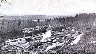
The Duwamish people lived along the Black River for many centuries. Duwamish settlements remained along the river until it dried up in 1916. [6] Several indigenous villages were located near the confluence of the Black and Duwamish rivers. The area was called "Inside Place" (Lushootseed: Dxwdəw, from which comes the word "Duwamish"), referring to its location inland from Puget Sound. Long used as a place of refuge, the area became home to many natives displaced by the growing city of Seattle, until the Black River dried up. [7] [8]

Duwamish people ethnic group

The Duwamish are a Lushootseed-speaking Native American tribe in western Washington, and the indigenous people of metropolitan Seattle, where they have been living since the end of the last glacial period. The Duwamish tribe descends from at least two distinct groups from before intense contact with people of European ancestry—the People of the Inside and the People of the Large Lake —and continues to evolve both culturally and ethnically. By historic language, the Duwamish are (Skagit-Nisqually) Lushootseed; Lushootseed is a Salishan language. Adjacent tribes throughout the Puget Sound-Strait of Georgia basin were, and are, interconnected and interrelated, yet distinct. Today, some Duwamish people are enrolled in the federally recognized Tulalip Tribes of Washington.

Lushootseed is the language or dialect continuum of several Salish Native American tribes of modern-day Washington state. Lushootseed is one of the Coast Salish languages. The latter is one of two main divisions of the Salishan language family.

The remnant of the Black River (at right) joins Green River to form the Duwamish (at left). Seen from the Fort Dent Pedestrian Bridge, 2009. This image looks upstream on the Black River and downstream on the Duwamish. Fort Dent Pedestrian Bridge 03.jpg
The remnant of the Black River (at right) joins Green River to form the Duwamish (at left). Seen from the Fort Dent Pedestrian Bridge, 2009. This image looks upstream on the Black River and downstream on the Duwamish.

See also

Related Research Articles

The Muckleshoot are a Lushootseed-speaking Native American tribe, part of the Coast Salish peoples of the Pacific Northwest. They are descendants of the Duwamish and Puyallup peoples whose traditional territory was located along the Green and White rivers, including up to the headwaters in the foothills of the Cascade Mountains, in present-day Washington State. Since the mid-19th century, their reservation is located in the area of Auburn, Washington, about 15 miles northeast of the port of Tacoma and 35 miles southeast of Seattle, another major port.

Lake Washington lake in Washington state, U.S.

Lake Washington is a large freshwater lake adjacent to the city of Seattle. It is the largest lake in King County and the second largest natural lake in the state of Washington, after Lake Chelan. It borders the cities of Seattle on the west, Bellevue and Kirkland on the east, Renton on the south and Kenmore on the north, and encloses Mercer Island. The lake is fed by the Sammamish River at its north end and the Cedar River at its south.

Lake Washington Ship Canal

The Lake Washington Ship Canal, which runs through the city of Seattle, connects the fresh water body of Lake Washington with the salt water inland sea of Puget Sound. The Hiram M. Chittenden Locks accommodate the approximately 20-foot (6.1 m) difference in water level between Lake Washington and the sound. The canal runs east–west and connects Union Bay, the Montlake Cut, Portage Bay, Lake Union, the Fremont Cut, Salmon Bay, and Shilshole Bay, which is part of the sound.

Montlake Cut

The Montlake Cut is the easternmost section of the Lake Washington Ship Canal, which passes through the city of Seattle, linking Lake Washington to Puget Sound. It is approximately 2,500 feet (760 m) long and 350 feet (110 m) wide. The center channel is 100 feet (30 m) wide and 30 feet (9.1 m) deep. The path along the cut was designated a National Recreation Trail as Montlake Cut National Waterside in 1971.

Union Bay (Seattle) bay of Lake Washington, Washington state, U.S.

Union Bay is a body of water located in Lake Washington, Seattle, Washington. The bay has the Laurelhurst neighborhood to the north and the Montlake and Madison Park neighborhoods to the south. The Evergreen Point Floating Bridge, which carries State Route 520, crosses over a portion of the bay.

Shilshole Bay bay of Puget Sound west of Ballard, Seattle, Washington, U.S.

Shilshole Bay is the part of Puget Sound east of a line drawn northeasterly from Seattle's West Point in the southwest to its Golden Gardens Park in the northeast. On its shores lie Discovery Park, the Lawton Wood section of the Magnolia neighborhood, the neighborhood of Ballard, and Golden Gardens Park. It is home to the Shilshole Bay Marina on Ballard's Seaview Avenue N.W. and communicates with the Lake Washington Ship Canal via the Ballard Locks.

Salmon Bay Bay between Ballard and Magnolia in Seattle

Salmon Bay is a portion of the Lake Washington Ship Canal—a canal which passes through the city of Seattle, linking Lake Washington to Puget Sound—that lies west of the Fremont Cut. It is the westernmost section of the canal, and empties into Puget Sound's Shilshole Bay. Because of the Hiram M. Chittenden Locks, the smaller, western half of the bay is salt water, and the eastern half is fresh water. Before construction of the Ship Canal, Salmon Bay was entirely salt water.

Green River (Duwamish River tributary) tributary of the Duwamish River in Washington, United States

The Green River is a 65-mile (105 km) long river in the state of Washington in the United States, arising on the western slopes of the Cascade Range south of Interstate 90.

Pipers Creek (Seattle)

Pipers Creek is a 1.4-mile (2.3 km) urban stream that is located in the Broadview and Blue Ridge neighborhoods of Seattle, Washington, in the United States.

Ballard Locks Shipping locks at seaward entry to the Lake Washington Ship Canal

The Hiram M. Chittenden Locks, or Ballard Locks, is a complex of locks at the west end of Salmon Bay, in Seattle, Washington's Lake Washington Ship Canal, between the neighborhoods of Ballard to the north and Magnolia to the south.

Bodies of water of Seattle

Located on a narrow isthmus between Puget Sound on the west and Lake Washington on the east, water comprises approximately 41% of the total area of the city of Seattle, Washington, USA. It was founded on the harbor of Elliott Bay, home to the Port of Seattle—in 2002, the 9th busiest port in the United States by TEUs of container traffic and the 46th busiest in the world.

Matthews Beach, Seattle Neighborhood in Seattle

Matthews Beach is a neighborhood in Seattle, Washington; it and Meadowbrook are the southern neighborhoods of the annexed township of Lake City (1954). Matthews Beach lies about 2 miles (3 km) northeast of the University of Washington, about 8 miles (13 km) northeast of Downtown.

History of Seattle before white settlement

Renton High School

Renton High School is a public secondary school in downtown Renton, Washington, U.S., about 10 miles southeast of downtown Seattle. Founded in 1911, it is the oldest high school in the Renton School District.

North Winds Weir Site on the Duwamish River, figures prominently in the legends of the Puget Sound native Salish people.

North Wind's Weir or North Wind's Fish Weir south of Seattle on the Duwamish River in Tukwila, Washington is a site that figures prominently in the oral traditions of the Salish people of the Puget Sound region. The legends describe battles between North Wind and South Wind for control of the region.

Denny-Renton Clay and Coal Company

Denny-Renton Clay and Coal Company, founded in 1892 as Denny Clay Company, was the largest producer of brick pavers in the world by 1905. An industry journal said in 1909 "The clay products of this company have long been a standard for general excellence in Seattle and the entire northwest" and described its products:

"Four great factories are operated by this big Seattle concern, one being devoted exclusively to the manufacture of sewer pipe, with a capacity of two miles of sewer pipe daily; one devoted exclusively to the manufacture of terra cotta; another, the Renton factory, manufactures paving brick of high quality, while the Taylor plant embraces the new sewer-pipe and hollow-ware, as well as the dry-press and fire-brick factories."

References

  1. U.S. Geological Survey Geographic Names Information System: Black River
  2. "The Green-Duwamish: A River System Re-Plumbed", The Green-Duwamish River: Connecting people with a diverse environment. Duwamish River Cleanup Coalition/TAG. No date, appears to be 2008 or 2009.
  3. "Cedar River floods Renton in November 1911". Archived from the original on 2011-06-11. Retrieved 2009-09-01.
  4. "Black River disappears in July 1916" . Retrieved 2018-02-09.
  5. "Black River Riparian Forest and Wetland" . Retrieved 2018-02-09.
  6. Herons Forever, History of the Black River
  7. Thrush, Coll (2007). Native Seattle: Histories from the Crossing-Over Place. University of Washington Press. p. 244. ISBN   0-295-98700-6.
  8. Mapes, Lynda. "Water's natural rhythms nourished our area's native culture. Then came the Ballard Locks". The Seattle Times. Retrieved 5 July 2017.

Coordinates: 47°28′27″N122°15′3″W / 47.47417°N 122.25083°W / 47.47417; -122.25083

Geographic coordinate system Coordinate system

A geographic coordinate system is a coordinate system that enables every location on Earth to be specified by a set of numbers, letters or symbols. The coordinates are often chosen such that one of the numbers represents a vertical position and two or three of the numbers represent a horizontal position; alternatively, a geographic position may be expressed in a combined three-dimensional Cartesian vector. A common choice of coordinates is latitude, longitude and elevation. To specify a location on a plane requires a map projection.