
Fort Bridger is a census-designated place (CDP) in eastern Uinta County, Wyoming, United States. The population was 345 at the 2010 census. The community takes its name from the eponymous Fort Bridger, established in 1842, which is located within the boundaries of the CDP.

Fort Bridger was originally a 19th-century fur trading outpost established in 1842, on Blacks Fork of the Green River, in what is now Uinta County, Wyoming, United States. It became a vital resupply point for wagon trains on the Oregon Trail, California Trail, and Mormon Trail. The Army established a military post here in 1858 during the Utah War, until it was finally closed in 1890. A small town, Fort Bridger, Wyoming, remains near the fort and takes its name from it.

The Wyoming State Capitol is the state capitol and seat of government of the U.S. state of Wyoming. Built between 1886 and 1890, the capitol is located in Cheyenne and contains the chambers of the Wyoming State Legislature as well as the office of the Governor of Wyoming. It was designated a U.S. National Historic Landmark in 1987. The Capitol underwent an extensive three-year renovation and reopened to the public on July 10, 2019.

Fort Laramie was a significant 19th-century trading post, diplomatic site, and military installation located at the confluence of the Laramie and the North Platte Rivers. They joined in the upper Platte River Valley in the eastern part of the present-day U.S. state of Wyoming. The fort was founded as a private trading-post in the 1830s to service the overland fur trade; in 1849, it was purchased by the United States Army. The site was located east of the long climb leading to the best and lowest crossing-point over the Rocky Mountains at South Pass and became a popular stopping-point for migrants on the Oregon Trail. Along with Bent's Fort on the Arkansas River, the trading post and its supporting industries and businesses were the most significant economic hub of commerce in the region.

U.S. Route 66 is a former east–west United States Numbered Highway, running from Santa Monica, California to Chicago, Illinois. In Missouri, the highway ran from downtown St. Louis at the Mississippi River to the Kansas state line west of Joplin. The highway was originally Route 14 from St. Louis to Joplin and Route 1F from Joplin to Kansas. It underwent two major realignments and several lesser realignments in the cities of St. Louis, Springfield, and Joplin. Current highways covering several miles of the former highway include Route 100, Route 366, Route 266, Route 96, and Route 66. Interstate 44 (I-44) approximates much of US 66 between St. Louis and Springfield.

Kingsley Plantation is the site of a former estate on Fort George Island, in Duval County, Florida, that was named for its developer and most famous owner, Zephaniah Kingsley, who spent 25 years there. It is located at the northern tip of Fort George Island at Fort George Inlet, and is part of the Timucuan Ecological and Historic Preserve managed by the U.S. National Park Service. Kingsley's house is the oldest plantation house still standing in Florida, and the solidly-built village of slave cabins is one of the best preserved in the United States. It is also "the oldest surviving antebellum Spanish Colonial plantation in the United States."
The Bridger Antelope Trap is an archaeological site in Uinta County, Wyoming, associated with local Indigenous hunting practices. As an important example of hunting and gathering strategies, the site provides important clues to native subsistance in the past. The Wyoming State Historic Preservation Office nominated the antelope trap for the National Register of Historic Places (NRHP). The NRHP added the site to the Register on 21 January 1971.

Apple River Fort, today known as the Apple River Fort State Historic Site, was one of many frontier forts hastily completed by settlers in northern Illinois and southern Wisconsin following the onset of the 1832 Black Hawk War. Located in present-day Elizabeth, Illinois, United States, the fort at the Apple River settlement was built in less than a week. It was one of the few forts attacked during the war and the only one attacked by a band led by Black Hawk himself. At the Battle of Apple River Fort, a firefight of about an hour ensued, with Black Hawk's forces eventually withdrawing. The fort suffered one militia man killed in action, and another wounded. After the war, the fort stood until 1847, being occupied by squatters before being sold to a private property owner who dismantled the building.

There is evidence of prehistoric human habitation in the region known today as the U.S. state of Wyoming stretching back roughly 13,000 years. Stone projectile points associated with the Clovis, Folsom and Plano cultures have been discovered throughout Wyoming. Evidence from what is now Yellowstone National Park indicates the presence of vast continental trading networks since around 1,000 years ago.

Blacks Fork is a 175-mile-long (282 km) tributary of the Green River in Utah and Wyoming in the United States.

The following is an alphabetical list of articles related to the U.S. state of Wyoming.
The UXU Ranch is a historic dude ranch in Shoshone National Forest near Wapiti, Wyoming. The ranch began as a sawmill, as early as 1898. In 1929 Bronson Case "Bob" Rumsey obtained a permit from the U.S. Forest Service to operate a dude ranch on the property, using the sawmill headquarters building, a lodge, and tent cabins. Most of the current structures were built in the 1920s and 1930s from lumber milled on the site.
The Fort Laramie Three-Mile Hog Ranch was built to serve as a social center away from the soldiers' post at historic Fort Laramie. Fort Laramie was a 19th-century military post in eastern Wyoming. It became notorious as a place for gambling and drinking, and for prostitution, with at least ten prostitutes always in residence. The location is notable as an example of one of only a few military bordellos still standing in the United States by 1974, the time of its nomination to the National Register of Historic Places The Fort Laramie site was one of a number of so-called "hog ranches" that appeared along trails in Wyoming.
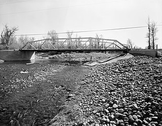
The ERT Bridge over Blacks Fork near Fort Bridger, Wyoming, was listed on the National Register of Historic Places in 1985 as part of a thematic study on early 20th century steel truss bridges in Wyoming. The ERT Bridge is a Warren pony truss bridge spanning 80 feet (24 m) with a width of 15.75 feet (4.80 m). Set on concrete abutments, the ERT Bridge was built around 1920 by Uinta County. It is an example of a transitional design from locally built bridges to standardized State designs

The Sussex Post Office and Store, also known as Sussex Community Hall, is located on the north bank of the Powder River in southeast Johnson County about twenty miles east of Kaycee, Wyoming. The store was built in 1914, and was listed on the National Register of Historic Places in 1998.

The Powder River Crossing, officially known as Powder River Station-Powder River Crossing , is an abandoned settlement located on the east bank of the Powder River in southeast Johnson County about twenty-four miles east of Kaycee, Wyoming. It developed after a wooden toll bridge was built across the Powder River in 1877, at a site that was originally used as a ford. With crossing secured, a settlement developed here in the late 19th century, incorporating a stage stop on the Bozeman Trail. The site is notable for having well-preserved wagon ruts from the pioneer era.

The Jim Baker Cabin was built in 1873 by frontiersman Jim Baker as a fortified house on the Little Snake River at Savery Creek near present-day Savery, Wyoming. The two-story log building measures 31 feet (9.4 m) by 16 feet (4.9 m) with two rooms on the lower level and a single smaller room on the upper level. The outer walls are made of logs 12 inches (30 cm) to 15 inches (38 cm) thick.
Wyoming Pioneer Association is an organization that aims to preserve Wyoming's pioneer history. The association was formed in 1884 and incorporated in 1926 in a small pioneer cabin located on the Wyoming State Fairgrounds in Douglas; the Wyoming legislature appropriated funds for construction of a museum at the same location in 1956, and the association expanded its facilities in 2013 to add the Ruthe James Williams Center.

The Capitol Boulevard Memorial Bridge, also known as the Oregon Trail Memorial Bridge, is a historic bridge over the Boise River in Boise, Idaho, United States, the is listed on the National Register of Historic Places.

Fort Supply was a Mormon pioneer-era fort in Green River County, Utah Territory, United States. Established in 1853 and abandoned during the Utah War of 1857, the fort served to solidify Mormon influence and control in the area, as a base for local missionary efforts, and to supply food and other provisions for pioneers headed to Salt Lake City. The site of the former fort is located near the modern-day community of Robertson, Uinta County, Wyoming, and a monument commemorating the settlement is maintained as a satellite site of Wyoming's Fort Bridger State Historic Site.


