Blackhall Road, Oxford

Last updated

Dinosaur graffiti in Blackhall Road, Oxford, in October 2006 Blackhall Road, Oxford - dinosaurs.JPG
Dinosaur graffiti in Blackhall Road, Oxford, in October 2006
The same graffiti in July 2019. Blackhall Road Oxford Dinosaur 2019.jpg
The same graffiti in July 2019.

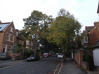
Blackhall Road is a road running between Keble Road to the north and Museum Road to the south in central Oxford, England, dating from the late 19th century. [1] It is named after Black Hall, dating from at least 1519, fronting onto St Giles', and now part of St John's College. [2] Houses in the road were leased by St John's College between 1865–75. [3]

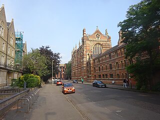
Keble College occupies the entire east side of the road, including the O'Reilly Theatre. In the 1970s, the architects Ahrends, Burton and Koralek designed yellow brick buildings on the southern part of Blackhall Road. [4] These include the "Elephant House" at the southern end, nicknamed due to its resemblance to the elephant house at London Zoo. [5]

At the southern end on the west side are houses owned by St John's College. [6] At the northern end to the west is the Department of Statistics of the University of Oxford, until 2013 the Mathematical Institute.

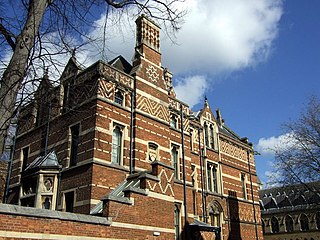
The historian J.K. Fotheringham (1874–1936), an expert on ancient astronomy and chronology, and Fellow of Magdalen College, lived at 6 Blackhall Road. [7] The classical historian Abel Hendy Jones Greenidge lived at 4 Blackhall Road. The poet and art critic Hasan Shahid Suhrawardy (1890–1965), an associate of the writer D.H. Lawrence, also lived in the road when they met in 1915. [8]

The road includes one of the longest lasting and still extant pieces of outdoor graffiti in Oxford. On a brick wall forming part of Keble College, opposite the Department of Statistics building, are two large dinosaurs in white and blue paint. The caption "REMEMBER WHAT HAPPENED TO THE DINOSAUR!" is next to the white dinosaur. By the blue dinosaur, perhaps intended to resemble an alligator, is a riposte "I DID, AND LOOK WHAT HAPPENED TO ME".

It is thought that the white graffiti, the earlier of the two, was the work of delegates at the Drapers' Conference at Keble in the early 1970s and was a reply to the students of Keble's neighbour St John's College who had formed the St John’s Destroy Keble Society. [9] Close by in Parks Road is the Oxford University Museum of Natural History where a number of fossilized dinosaur skeletons can be seen. There was a hatching-dinosaur-egg addition on the wall for a while but it has disappeared.

Related Research Articles

<span class="mw-page-title-main">Keble College, Oxford</span> College of University of Oxford

Keble College is one of the constituent colleges of the University of Oxford in England. Its main buildings are on Parks Road, opposite the University Museum and the University Parks. The college is bordered to the north by Keble Road, to the south by Museum Road, and to the west by Blackhall Road.

<span class="mw-page-title-main">North Oxford</span> Human settlement in England

North Oxford is a suburban part of the city of Oxford in England. It was owned for many centuries largely by St John's College, Oxford and many of the area's Victorian houses were initially sold on leasehold by the college.

<span class="mw-page-title-main">Banbury Road</span> Arterial road in Oxford, England

Banbury Road is a major arterial road in Oxford, England, running from St Giles' at the south end, north towards Banbury through the leafy suburb of North Oxford and Summertown, with its local shopping centre. Parallel and to the west is the Woodstock Road, which it meets at the junction with St Giles'. To the north, Banbury Road meets the Oxford Ring Road at a roundabout. The road is designated the A4165. Prior to the building of the M40 motorway extension in 1990, the road formed part of the A423 from Maidenhead to Coventry.

<span class="mw-page-title-main">Parks Road</span> Road in Oxford, England

Parks Road is a road in Oxford, England, with several Oxford University colleges along its route. It runs north–south from the Banbury Road and Norham Gardens at the northern end, where it continues into Bradmore Road, to the junction with Broad Street, Holywell Street and Catte Street to the south.

<span class="mw-page-title-main">Museum Road</span> Short road in central Oxford, England

Museum Road is a short road in central Oxford, England. It leads to the Oxford University Museum of Natural History and the Radcliffe Science Library at its eastern end where it meets Parks Road. At its west end is a junction with Blackhall Road. It continues as the Lamb & Flag Passage past the Lamb & Flag public house on St Giles', a meeting place of J.R.R. Tolkien and the Inklings.

<span class="mw-page-title-main">Keble Road</span> Road in central Oxford, England

Keble Road is a short road running east–west in central Oxford, England. To the west is the southern end of the Banbury Road with St Giles' Church opposite. To the east is Parks Road with the University Parks opposite. Blackhall Road leads off the road to the south near the western end.

<span class="mw-page-title-main">Abingdon Road</span> Road to the south of Oxford, England

Abingdon Road is the main arterial road to the south of the city of Oxford, England. The road passes through the suburbs of Grandpont and New Hinksey. It is named after the town of Abingdon to the south.

<span class="mw-page-title-main">Bevington Road</span> Residential road in North Oxford, England

Bevington Road is a residential road in central North Oxford, England.

<span class="mw-page-title-main">Canterbury Road</span> Road in North Oxford, England

Canterbury Road is a road in North Oxford, England. It runs between Woodstock Road to the west and Banbury Road to the east. Winchester Road leads south from halfway along Canterbury Road, linking with Bevington Road that runs parallel to the south. Also to the south are North Parade and Church Walk.

<span class="mw-page-title-main">Winchester Road, Oxford</span> Road in North Oxford, England

Winchester Road is a road in North Oxford, England. It runs north–south between and roughly parallel with Woodstock Road to the west and Banbury Road to the east. It is in a desirable area with high house prices.

<span class="mw-page-title-main">Polstead Road</span> Road in North Oxford, England

Polstead Road is a residential road that runs between Kingston Road and Hayfield Road to the west and the Woodstock Road to the east, in the suburb of North Oxford, England. Halfway along it forms the southern junction of Chalfont Road. The road is probably named after the village of Polstead in the county of Suffolk.

<span class="mw-page-title-main">Charlbury Road</span> Road in North Oxford, England

Charlbury Road is a road in North Oxford, England, running to the east of and parallel with the Banbury Road.

<span class="mw-page-title-main">St Giles' Church, Oxford</span> Church in Oxford, United Kingdom

St. Giles' Church is a church in North Oxford, England. It is at the northern end of the wide thoroughfare of St Giles', at the point where it meets Woodstock Road and Banbury Road. It stands between where Little Clarendon Street joins Woodstock Road and Keble Road joins Banbury Road.

<span class="mw-page-title-main">Mansfield Road, Oxford</span> Road in central Oxford, England

Mansfield Road is a road in central Oxford, England. It runs north-south with two of Oxford University's colleges on it, Mansfield College and Harris Manchester College, and Queen Elizabeth House which houses the Oxford Department of International Development.

<span class="mw-page-title-main">Denys Wilkinson Building</span>

The Denys Wilkinson Building is a prominent 1960s building in Oxford, England, designed by Philip Dowson at Arup in 1967.

<span class="mw-page-title-main">Rawlinson Road</span>

Rawlinson Road is a residential road in North Oxford, England.

<span class="mw-page-title-main">Farndon Road</span> Road in North Oxford, England

Farndon Road is a residential road in North Oxford, England.

<span class="mw-page-title-main">Bradmore Road</span> Road in North Oxford, England

Bradmore Road is a residential road in North Oxford, England.

<span class="mw-page-title-main">Fyfield Road</span> Road in North Oxford, England

Fyfield Road is a residential road in North Oxford, England, on the Norham Manor estate.

<span class="mw-page-title-main">Warnborough Road</span> Road in North Oxford, England

Warnborough Road is a residential road in North Oxford, England.

References

  1. Hibbert, Christopher, ed. (1988). "Blackhall Road". The Encyclopaedia of Oxford . Macmillan. p. 44. ISBN   0-333-39917-X.
  2. "No. 21: Part of St John's College". St Giles', Oxford. Oxford History. Retrieved 11 June 2012.
  3. Hinchcliffe, Tanis (1992). North Oxford. New Haven & London: Yale University Press. pp. 51, 204, 220. ISBN   0-14-071045-0.
  4. Jennifer Sherwood and Nikolaus Pevsner, The Buildings of England: Oxfordshire. Penguin Books, 1974. ISBN   0-14-071045-0. Page 229.
  5. The Elephant House — Keble College (Oxford) , Wikimapia.
  6. Geoffrey Tyack, Modern architecture in an Oxford college: St John's College, 1945–2005 . Oxford University Press, 2005, page 52. ISBN   978-0-19-927162-7.
  7. Proceedings of the Classical Association , volumes 26–28. Classical Association, 1929.
  8. David Farmer, John Worthen, and Lindeth Vasey (editors), The Cambridge Edition of the Works of D.H. Lawrence: Women in Love . Cambridge University Press, 1987, page 586. ISBN   0-521-23565-0; ISBN   0-521-28041-9.
  9. "The Keble Dinosaur". 2013. Archived from the original on 13 April 2019. Retrieved 5 February 2015.

51°45′31″N1°15′31″W / 51.7585°N 1.2585°W / 51.7585; -1.2585