
The Merrick, or simply Merrick, is a mountain in the Range of the Awful Hand, a sub-range of the Galloway Hills range, part of the Southern Uplands of Scotland. The summit elevation is 843 metres, making it the highest mountain in the Southern Uplands and southern Scotland.

Broad Law is a hill in the Manor Hills range, part of the Southern Uplands of Scotland. The second highest point in the Southern Uplands and the highest point in the Scottish Borders, it has an elevation of 840 metres, a prominence of 653 metres and an isolation of 81 kilometres. It is only 3 m (10 ft) lower than its parent, Merrick. Like many of its neighbours it is smooth, rounded and grassy, although the surrounding glens have very steep sides — country somewhat akin to the Cheviots or the Howgill Fells. The hill is most easily climbed from the Megget Stane to the south, beginning at an elevation of 452 m (1,483 ft), but is also frequently climbed from the villages near its base, or as part of a long, 50 km (30 mi) trek across the local area between the towns of Peebles and Moffat. On the summit is the highest VOR beacon in the UK, and also a radio tower.

The mountains and hills of the British Isles are categorised into various lists based on different combinations of elevation, prominence, and other criteria such as isolation. These lists are used for peak bagging, whereby hillwalkers attempt to reach all the summits on a given list, the oldest being the 282 Munros in Scotland, created in 1891.

The Range of the Awful Hand is a range of hills in the Galloway Hills range, part of the Southern Uplands of Scotland. The most westerly of three parallel ridges, the range is neighboured to the east by the Dungeon Hills and the Rhinns of Kells. The Minnigaff Hills also lie southeast. In total, these four ranges are part of the Galloway Forest Park. The ridge is split between South Ayrshire and Dumfries and Galloway.

The Moorfoot Hills are a range of hills south of Edinburgh in east central Scotland, one of the ranges which collectively form the Southern Uplands.

Erie Hill is a hill in the Moffat Hills range, part of the Southern Uplands of Scotland. A relatively compact summit in comparison to the other hills in the range, it is commonly climbed as part of a round starting from Talla Linnfoots to the north.

Molls Cleuch Dod is a hill in the Moffat Hills range, part of the Southern Uplands of Scotland. A broad, grassy outlier of the surrounding hills, it is commonly ascended in rounds beginning from the Megget Stane and Talla Linnfoots or as a detour from the Grey Mare's Tail.

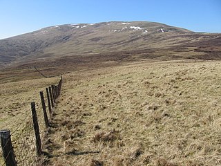
Under Saddle Yoke is a hill in the Moffat Hills range, part of the Southern Uplands of Scotland. Despite its name, it is 10m higher than its neighbouring top, Saddle Yoke. Located in a dramatic position on a small, grassy ridge in between two deep glens, Blackhope and Carrifran, it awards excellent views into the rest of the Moffat Hills and the Ettrick Hills opposite. Although incomparable to the Scottish Highlands and not particularly precipitous, the ridge between and atop the Yokes is the narrowest summit ridge in the Southern Uplands. The electric fence that comes out of Blackshope and crosses the ridge to the north of Saddle Yoke and then continues down into Carrifran hasn't worked in 40 years. A popular round known as the Hart Fell Horseshoe begins near Blackshope and normally ascends Nether Coomb Craig first, then passing over Swatte Fell, Hart Fell and looping round Hartfell Rig to the Saddle Yokes before the descent.
Blackcraig Hill is a hill in the Carsphairn and Scaur Hills range, part of the Southern Uplands of Scotland. It lies southeast of the town of New Cumnock in Ayrshire. A craggy hill, it is usually climbed from its western side starting at Glen Afton.

Milldown is a hill in the Rhinns of Kells, a sub-range of the Galloway Hills range, part of the Southern Uplands of Scotland. It is located immediately north of Meikle Millyea - between these two hills lie the Lochans of Auchniebut, a series of small water bodies at an approximate elevation of 650m - possibly the highest permanent water bodies in the Southern Uplands. As well as this, the hill is also flanked on its SW side by forest plantation - possibly the highest planted commercial forestry in the Southern Uplands. Like most of its neighbours, it is most easily climbed from the east at Forrest Lodge.
The Manor Hills, also known as the Tweedsmuir Hills, are a range of hills south of Peebles in the Scottish Borders, one of the ranges which collectively form the Southern Uplands. They are separated from the Moffat Hills by the Talla Reservoir, Megget Reservoir and St. Mary's Loch, the Moorfoot Hills by the A72 and the Culter Hills in South Lanarkshire by the A701. The western portion of the hills are designated as the 'Tweedsmuir Hills' Site of Special Scientific Interest and the 'Upper Tweeddale' National Scenic Area, with the major tributary rivers designated as Special Areas of Conservation.

Meaul is a hill in the Rhinns of Kells, a sub-range of the Galloway Hills range, part of the Southern Uplands of Scotland. It is climbed from a number of directions; most commonly from Garryhorn near Carsphairn, often as part of a complete traverse of the ridge.

Alhang is a hill in the Carsphairn and Scaur Hills range, part of the Southern Uplands of Scotland. It is the lowest Donald hill in the range; Meikledodd Hill is 1m higher. The northern slopes of the hill are the source of the River Afton. It is most easily climbed from the Water of Ken to the east or as a round from Glen Afton to the north.

Whitehope Heights is a hill in the Moffat Hills range, part of the Southern Uplands of Scotland. The lowest Donald hill in the range, it is separated from Hart Fell by a steep grassy cleuch known as The Gyle. Like its neighbour, the Dumfries and Galloway-Scottish Borders border runs along its summit. The southern slopes of the hill are part of the Corehead hill farm, an area owned by the Borders Forest Trust for the purposes of habitat regeneration; as a result, a large deer fence lines the boundary. East of the Devil's Beef Tub and Annandale Way, it is most frequently climbed from this direction, but ascents from Hart Fell are also common.
The Dungeon Hills are a range of hills in the Galloway Hills range, part of the Southern Uplands of Scotland. The central of three parallel ridges, they are neighboured by the Range of the Awful Hand to the west and the Rhinns of Kells to the east. The range is also perpendicular to the Minnigaff Hills range, immediately south. In total, these four ranges are part of the Galloway Forest Park.

The Rhinns of Kells are a range of hills in the Galloway Hills range, part of the Southern Uplands of Scotland. The most easterly of three parallel ridges, they are neighboured to the west by the Range of the Awful Hand and the Dungeon Hills. The eastern portion of the Minnigaff Hills range lies immediately southwest of the range. In total, these four ranges are part of the Galloway Forest Park. The ridge is located entirely within Dumfries and Galloway, with the base of the western flanks being a northwestern boundary of the county.
The Minnigaff Hills are a range of hills in the Galloway Hills range, part of the Southern Uplands of Scotland. A southerly range, they are perpendicular to the Range of the Awful Hand, Dungeon Hills and Rhinns of Kells to the north. In total, these four ranges are part of the Galloway Forest Park.

The Culter Hills, Coulter Fells or variations thereof, are a range of hills, part of the Southern Uplands of Scotland. They are neighboured to the east by the Manor Hills and are split roughly in half by the border between South Lanarkshire and the Scottish Borders.

The Ettrick Hills are a range of hills, part of the Southern Uplands of Scotland. They are neighboured to the northwest by the Moffat Hills and are located mainly within the Scottish Borders, however the Dumfries and Galloway border covers the south and southwesterly flanks.
