Belfast is the capital city and principal port of Northern Ireland, standing on the banks of the River Lagan and connected to the open sea through Belfast Lough and the North Channel. It is the second-largest city on the island of Ireland, with an estimated population of 348,005 in 2022, and a metropolitan area population of 671,559.

Marquess of Donegall is a title in the Peerage of Ireland held by the head of the Chichester family, originally from Devon, England. Sir John Chichester sat as a Member of Parliament and was High Sheriff of Devon in 1557. One of his sons, Sir Arthur Chichester, was Lord Deputy of Ireland from 1605 to 1616. In 1613, he was raised to the Peerage of Ireland as Baron Chichester, of Belfast in County Antrim. When he died childless in 1625 the barony became extinct.
The News Letter is one of Northern Ireland's main daily newspapers, published from Monday to Saturday. It is the world's oldest English-language general daily newspaper still in publication, having first been printed in 1737. The newspaper's editorial stance and readership, while originally republican at the time of its inception, is now unionist. Its primary competitors are the Belfast Telegraph and The Irish News.

The River Lagan is a major river in Northern Ireland which runs 53.5 mi (86.1 km) from the Slieve Croob mountain in County Down to Belfast where it enters Belfast Lough, an inlet of the Irish Sea. The Lagan forms much of the border between County Antrim and County Down in the east of Ulster. It rises as a tiny, fast-moving stream near to the summit of Slieve Croob; Transmitter Road runs nearby. It runs to Belfast through Dromara, Donaghcloney and Dromore. On the lower slopes of the mountain, it combines with a branch from Legananny Mountain, just opposite Slieve Croob. The river then turns east to Magheralin into a broad plain between the plateaus of Antrim and Down.

The Falls Road is the main road through West Belfast, Northern Ireland, running from Divis Street in Belfast City Centre to Andersonstown in the suburbs. The name has been synonymous for at least a century and a half with the Catholic community in the city. The road is usually referred to as the Falls Road, rather than as Falls Road. It is known in Irish as the Bóthar na bhFál and as the Faas Raa in Ulster-Scots.

The M1 is a motorway in Northern Ireland. It is the longest motorway in Northern Ireland and runs for 38 miles (61 km) from Belfast to Dungannon through County Antrim, County Down, County Armagh and County Tyrone. It forms part of the route via the A1 in Northern Ireland between Belfast and Dublin as well as being a part of the unsigned European E01 and E18 routes.
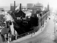
The Laganside Corporation was a non-departmental public body formed by the Laganside Development Order 1989 with the goal of regenerating large sections of land in Belfast, Northern Ireland adjacent to the River Lagan. This development area was expanded in 1996 to include areas closer to the city centre.

Henry Joy McCracken was an Irish republican executed in Belfast for his part in leading United Irishmen in the Rebellion of 1798. Convinced that the cause of representative government in Ireland could not be advanced under the British Crown, McCracken had sought to forge a revolutionary union between his fellow Presbyterians in Ulster and the country's largely dispossessed Catholic majority. In June 1798, following reports of risings in Leinster, he seized the initiative from a leadership that hesitated to act without French assistance and led a rebel force against a British garrison in Antrim Town. Defeated, he was returned to Belfast where he was court-martialled and hanged.

Belfast Castle is a mansion located in Cave Hill Country Park in Belfast, Northern Ireland, in a prominent position 400 feet (120 m) above sea level. Its location provides unobstructed views over the City of Belfast and Belfast Lough. There have been several structures called "Belfast Castle" over the centuries, located on different sites. The current "castle" is a Victorian structure, built between 1867 and 1870 on the slopes of Cave Hill, and is Grade A listed. The main entrance into the Belfast Castle Demesne is now where Innisfayle Park meets Downview Park West, just off the Antrim Road. The original main entrance into the current demesne was formerly on the Antrim Road itself, where Strathmore Park now meets the Antrim Road.

The River Farset is a river in Belfast, Northern Ireland. It is a late tributary of the River Lagan.
Belfast was an Irish borough constituency in the House of Commons of the United Kingdom of Great Britain and Ireland. Comprising the city of Belfast, it elected one Member of Parliament (MP) from 1801 to 1832, and then two MPs from 1832 until the constituency was divided by the Redistribution of Seats Act 1885 before the 1885 general election.

Stranmillis is an area in south Belfast, Northern Ireland. It is also an electoral ward for Belfast City Council, part of the Laganbank district electoral area. As part of the Queen's Quarter, it is the location for prominent attractions such as the Ulster Museum and Botanic Gardens. The area is located on Stranmillis Road, with Malone Road to the west and the River Lagan to the east. Its name, meaning "the sweet stream" in Irish, refers to the Lagan, whose waters are still fresh at this point, before becoming brackish as the river flows onward toward its mouth in Belfast Lough.
Sandy Row is an inner city area of south Belfast, Northern Ireland, which is predominantly Protestant working-class. In 2018, the population was estimated to be around 4,000. It is a staunchly loyalist area and heartland of the paramilitary Ulster Defence Association (UDA) and Orange Order.

Dunmurry is a suburban town and townland near Belfast, Northern Ireland. Dunmurry is in the Collin electoral ward for the local government district of Belfast City Council.

The Donegall Road is a residential area and road traffic thoroughfare that runs from Shaftesbury Square on what was once called the "Golden Mile" to the Falls Road in west Belfast. The road is bisected by the Westlink – M1 motorway. The largest section of the road, east of the Broadway junction with the Westlink, has a community which self-identifies as predominantly Protestant while the community on the other side of the Westlink – M1 motorway self-identifies as predominantly Catholic.

Northern Ireland is divided into six counties, namely: Antrim, Armagh, Down, Fermanagh, Londonderry and Tyrone. Six largely rural administrative counties based on these were among the eight primary local government areas of Northern Ireland from its 1921 creation until 1973. The other two local government areas were the urban county boroughs of Derry and Belfast.

John Harold Hewitt was perhaps the most significant Belfast poet to emerge before the 1960s generation of Northern Irish poets that included Seamus Heaney, Derek Mahon and Michael Longley. He was appointed the first writer-in-residence at Queen's University Belfast in 1976. His collections include The Day of the Corncrake (1969) and Out of My Time: Poems 1969 to 1974 (1974). He was also made a Freeman of the City of Belfast in 1983, and was awarded honorary doctorates by the University of Ulster and Queen's University Belfast.
Transportation systems in the city of Belfast, Northern Ireland, include road, air, rail, and sea. It is still a relatively car-dependent city; however, it is also served by a comprehensive rail and bus network. Belfast also ran electric trams prior to 1954. The city has two major airports, and the Port of Belfast is the busiest ferry port on the island of Ireland.

Ormeau Road is a road in south Belfast, the capital of Northern Ireland. Ormeau Park is adjacent to it. It forms part of the A24.
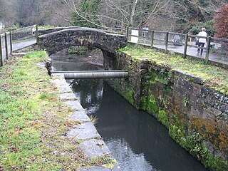
The Lagan Canal was a 44-kilometre (27 mi) canal built to connect Belfast to Lough Neagh. The first section, which is a river navigation, was opened in 1763, and linked Belfast to Lisburn. The second section from Lisburn to Lough Neagh includes a small amount of river navigation, but was largely built as a canal. At its peak it was one of the most successful of the Irish canals, but ultimately it was unable to compete with road and rail transport, and the two sections were closed in 1954 and 1958. The central section from Sprucefield to Moira was destroyed by the construction of the M1 motorway in the 1960s. Responsibility for most of its remains passed first to the Department of Agriculture and then to the Department of Culture, Arts and Leisure, although the section between Aghalee Bridge and Lough Neagh, including the final ten locks, passed into private ownership. There is an active campaign to re-open the canal, including reinstatement of the central section.