
Askham Bog is small area of peat bog and Site of Special Scientific Interest situated within the Vale of York in North Yorkshire, England. It lies to the south-west of York, north of Copmanthorpe and near Askham Richard and Askham Bryan. It is regarded as one of the most ecologically diverse sites in Northern England.
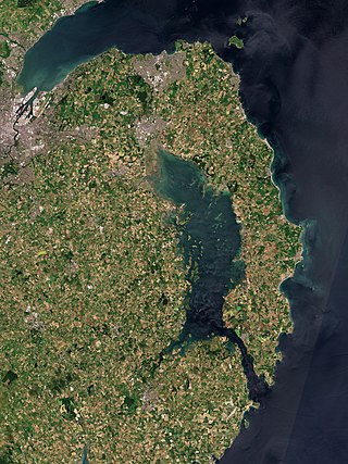
Strangford Lough is a large sea lough or inlet in County Down, in the east of Northern Ireland. It is the largest inlet in Ireland and the wider British Isles, covering 150 km2 (58 sq mi). The lough is almost fully enclosed by the Ards Peninsula and is linked to the Irish Sea by a long narrow channel at its southeastern edge. The main body of the lough has at least seventy islands along with many islets (pladdies), bays, coves, headlands and mudflats. It is part of the Strangford and Lecale Area of Outstanding Natural Beauty. Strangford Lough was designated as Northern Ireland's first Marine Conservation Zone in 2013, and has been designated a Special Area of Conservation for its important wildlife.

The River Lagan is a major river in Northern Ireland which runs 53.5 mi (86.1 km) from the Slieve Croob mountain in County Down to Belfast where it enters Belfast Lough, an inlet of the Irish Sea. The Lagan forms much of the border between County Antrim and County Down in the east of Ulster. It rises as a tiny, fast-moving stream near to the summit of Slieve Croob; Transmitter Road runs nearby. It runs to Belfast through Dromara, Donaghcloney and Dromore. On the lower slopes of the mountain, it combines with a branch from Legananny Mountain, just opposite Slieve Croob. The river then turns east to Magheralin into a broad plain between the plateaus of Antrim and Down.

The Cotswold Water Park is the United Kingdom's largest marl lake system, straddling the Wiltshire–Gloucestershire border, north-west of Cricklade and south of Cirencester. There are 180 lakes, spread over 42 square miles (110 km2).
Ballynahone Bog is a raised bog, situated in County Londonderry, Northern Ireland, about 3 km south of Maghera, on low-lying ground immediately north of the Moyola River about 14 km from its mouth at Lough Neagh. It is one of the largest lowland raised bogs in Northern Ireland.

Gordano is an area of North Somerset, in England. It has been designated as a National Nature Reserve.
Yanal Bog is a 1.6 hectare biological Site of Special Scientific Interest on the southern edge of the North Somerset Levels, just north of the village of Sandford, North Somerset. It was notified as an SSSI in 1988.

Lambert's Castle is an Iron Age hillfort in the county of Dorset in southwest England. Since 1981 it has been designated as a Site of Special Scientific Interest (SSSI) on account of its geology, archaeology and ecology. The hillfort is designated a scheduled monument together with a bowl barrow, the sites of a post-medieval fair and a telegraph station. The site was on the Heritage at Risk Register but was removed in 2022 as a result of the Hillforts and Habitats Project.

The Belfast Naturalists' Field Club is a club of naturalists based in Belfast, Northern Ireland. Founded in 1863, the club was an important part of the education system for Victorian naturalists and worked largely through first-hand field studies. It has been credited with playing an important role in the elucidation of glacial and post-glacial sea levels, climates and fossil beaches and issuing the first of the regional handbooks for meetings of the British Association for the Advancement of Science as far back as 1874. The club has four sections, Archeology & History, Botany, Geology and Zoology, and has published several books and a periodical. The Herbarium of the BNFC is now in the Ulster Museum.

Purple moor grass and rush pastures is a type of Biodiversity Action Plan habitat in the UK. It occurs on poorly drained neutral and acidic soils of the lowlands and upland fringe. It is found in the South West of England, especially in Devon.

The Blackstaff River is a watercourse in County Antrim, Northern Ireland. It rises on the eastern slope of the Black Mountain before flowing down into the Bog Meadows and passing under the city of Belfast, where it enters the River Lagan. Much of its course has been culverted and built upon since the 19th century, making it largely invisible today. Its tributaries include the Forth or Clowney River, which meets it beneath the Broadway Roundabout in West Belfast.
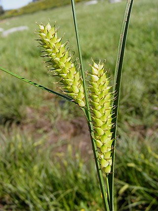
Carex vesicaria is an essentially Holarctic species of sedge known as bladder sedge, inflated sedge, and blister sedge. It has been used to insulate footwear in Norway and among the Sami people, and for basketry in North America.
Trodds Copse is a 25.23 hectare biological Site of Special Scientific Interest (SSSI), in central Hampshire, notified in 1989. It comprises ancient semi-natural woodland, unimproved meadows and flushes.

Ireland is in the Atlantic European Province of the Circumboreal Region, a floristic region within the Holarctic.

Carex lacustris, known as lake sedge, is a tufted grass-like perennial of the sedge family (Cyperaceae), native to southern Canada and the northern United States. C. lacustris us an herbaceous surface-piercing plant that grows in water up to 50 cm (1.6 ft) deep, and grows 50–150 cm (1.6–4.9 ft) tall. It grows well in marshes and swampy woods of the boreal forest, along river and lake shores, in ditches, marshes, swamps, and other wetland habitat. It grows on muck, sedge peat, wet sand or silt, in filtered or full sunlight.

Bewick and Beanley Moors is the name given to a Site of Special Scientific Interest (SSSI) in north Northumberland, in the north-east of England. The moors are asserted to be of national importance by Natural England for the extent, quality and diversity of upland types including heaths, fens, wet grassland, flushes, mires and blanket bogs, together creating an extensive mosaic habitat supporting an exceptional community of amphibians. The moors are important, too, for their relict juniper woodland and scrub.
Ron Ward's Meadow With Tadley Pastures is a site of Site of Special Scientific Interest (SSSI). It is based on the edge of Tadley in Hampshire, England. It is managed by the Hampshire and Isle of Wight Wildlife Trust.
Farnham Mires is a Site of Special Scientific Interest, or SSSI, to the west of the village of Farnham, North Yorkshire, England. It consists of a spring-fed marshy fen or mire with reeds and sedge, and drier calcareous grassland containing a diverse range of flora. It has a history of poaching and fox hunting, but since the late 19th century, the attention of botanists has been drawn to its large variety of flowering plants. It has received some consideration on this account since 1944, and from 1954 it was designated SSSI status. This site has no facilities, and is not open to the public.

Mar Field Fen is a Site of Special Scientific Interest, or SSSI, north of Masham, North Yorkshire, England, in a rural area known as Marfield. It is situated on land containing woodland carr, fen, spring-fed marshy grassland and drier calcareous grassland, between the River Ure to the east and Marfield Wetland nature reserve to the west. As "one of the best examples of fen habitat in the Vale of York," it is a protected habitat for a variety of plants, including the common butterwort, a carnivorous plant. There is no public access to this site.
