Politics of Suriname take place in a framework of a parliamentary representative democratic assembly-independent republic, whereby the president of Suriname is the head of state and head of government, and of a pluriform multi-party system. Executive power is exercised by the government. The executive power is dependent on the Parliament in theory. Legislative power is vested in both the government and the National Assembly. The judiciary is independent of the executive and the legislature.

The Republic of Suriname has a number of forms of transport. Transportation emissions are an increasing part of Suriname's contributions to climate change, as part of the Nationally Determined Contributions for the Paris Agreement, Suriname has committed to emissions controls for vehicles and increased public transit investment.
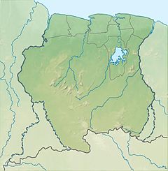
Suriname is divided into 10 districts.

Nickerie is a district of Suriname, on the north-west coast. Nickerie's capital city is Nieuw-Nickerie. Another town is Wageningen. The district borders the Atlantic Ocean to the north, the Surinamese district of Coronie to the east, the Surinamese district of Sipaliwini to the south and the region of East Berbice-Corentyne in Guyana to the west.

Sipaliwini is the largest district of Suriname, located in the south. Sipaliwini is the only district that does not have a regional capital, as it is directly administered by the national government in Paramaribo. Sipaliwini District includes disputed areas, with the southwestern region controlled and administered by Guyana, whereas the southeastern region is controlled by French Guiana.

Nieuw Nickerie is the third largest city in Suriname with a population estimated at 12,818. It is the capital city of the Nickerie district, and the terminus of the East-West Link.

Wageningen is a community resort and an agricultural place in the Republic of Suriname and located in the coastal area of West Suriname in the Nickerie District, at the harbour of the Nickerie River across the right estuary of the Maratakka River. The town was known as the rice centre of Suriname, Wageningen has been founded in 1949 and named after the Dutch city of Wageningen.
The Nickerie River is a river in the northwestern part of Suriname.

Paradise is a village in the Nickerie District of Suriname. It has a population of about 966 residents. The village is located about two kilometers from the town of Nieuw Nickerie.

Jagernath Lachmon, also Jaggernath Lachmon, was a Surinamese politician. He was one of the founders of the Progressive Reform Party (VHP), an Indo-Surinamese party founded in 1947 of which he served as President until his death.
Major Henk Fernandes Airport, also known as Nieuw Nickerie Airport, is near Nieuw Nickerie, the capital city of the Nickerie district in Suriname. This is one of the oldest airports in Suriname, in use since 1953, when the Piper Cub (PZ-NAC) of Kappel-van Eyck named "Colibri" landed there from Zorg en Hoop Airport.

Groot Henar is a resort in Suriname, located in the Nickerie District, near the bridge over the Nickerie River. Its population at the 2012 census was 2,709, most of which are East Indian. The resort has been named after the plantation Henar which was turned into small agricultural plots after the abolition of slavery. The cultivatable area was increased with the Henarpolder created in the 1920s. 1970 the Europolder was created adding 3,700 hectares to the resort.

Oostelijke Polders is a resort in Suriname located in the Nickerie District. Its population at the 2012 census was 7,153. Villages in the resort include Glasgow, Hamptoncourtpolder, and Paradise. Oostelijke Polders is an agricultural area with a focus on rice production. Oostelijke Polder has a clinic and a school.

Coeroeni is a resort in Suriname, located in the Sipaliwini District. Its population at the 2012 census was 1,046. The resort is mainly inhabited by indigenous people of the Tiriyó tribe. Kwamalasamutu is the main village of the resort and home to the granman Asongo Alalaparu.
The (northern) East-West Link is a road in Suriname between Albina in the eastern part of the country to Nieuw Nickerie in the western part, via the capital city of Paramaribo. The southern East-West Link connects Paramaribo with Apoera via Bitagron. Construction of the road link started in the 1960s.

Ronnie Brunswijk is a Surinamese politician, businessman, former rebel leader, footballer and convicted drug trafficker, who is serving as the current Vice President of Suriname.
Harriët Balfour also Schoonebeek and Kirke was a freed slave from Nickerie, Suriname.

Voltzberg is a mountain in Suriname at 240 metres (787 ft). It is part of the Emma Range and is located in the Sipaliwini District. It is named after the German geologist Friedrich Voltz. Voltzberg used to form a nature reserve together with the close by Raleigh Falls. In 1998, it became part of the Central Suriname Nature Reserve.

The Wayambo River is a river of Suriname. The river is part of an inland waterway connecting the harbour of Nieuw-Nickerie with Paramaribo.
Asraf Peerkhan Stadion, formerly the Nickerie Voetbal Stadion, is a football stadium in Nieuw Nickerie, Nickerie, Suriname. The stadium has a capacity of 3,400 visitors. It is the home stadium of Nickerie Voetbal Bond (NVB), the football union for the Nickerie District. The stadium was constructed in 1933. It used to be called Nickerie Voetbal Stadion. On 17 December 2017, the members of the NVB voted to change the name to Asraf Peerkhan Stadion in honour of Asraf Peerkhan.