
The North American plate is a tectonic plate containing most of North America, Cuba, the Bahamas, extreme northeastern Asia, and parts of Iceland and the Azores. With an area of 76 million km2 (29 million sq mi), it is the Earth's second largest tectonic plate, behind the Pacific plate.

The Juan de Fuca plate is a small tectonic plate (microplate) generated from the Juan de Fuca Ridge that is subducting beneath the northerly portion of the western side of the North American plate at the Cascadia subduction zone. It is named after the explorer of the same name. One of the smallest of Earth's tectonic plates, the Juan de Fuca plate is a remnant part of the once-vast Farallon plate, which is now largely subducted underneath the North American plate.

The Gorda plate, located beneath the Pacific Ocean off the coast of northern California, is one of the northern remnants of the Farallon plate. It is sometimes referred to as simply the southernmost portion of the neighboring Juan de Fuca plate, another Farallon remnant.

The Explorer plate is an oceanic tectonic plate beneath the Pacific Ocean off the west coast of Vancouver Island, Canada, which is partially subducted under the North American plate. Along with the Juan de Fuca plate and Gorda plate, the Explorer plate is a remnant of the ancient Farallon plate, which has been subducted under the North American plate. The Explorer plate separated from the Juan de Fuca plate roughly 4 million years ago. In its smoother, southern half, the average depth of the Explorer plate is roughly 2,400 metres (7,900 ft) and rises up in its northern half to a highly variable basin between 1,400 metres (4,600 ft) and 2,200 metres (7,200 ft) in depth.

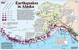
The Cascadia subduction zone is a 960 km (600 mi) fault at a convergent plate boundary, about 100–200 km (70–100 mi) off the Pacific coast, that stretches from northern Vancouver Island in Canada to Northern California in the United States. It is capable of producing 9.0+ magnitude earthquakes and tsunamis that could reach 30 m (98 ft). The Oregon Department of Emergency Management estimates shaking would last 5–7 minutes along the coast, with strength and intensity decreasing further from the epicenter. It is a very long, sloping subduction zone where the Explorer, Juan de Fuca, and Gorda plates move to the east and slide below the much larger mostly continental North American plate. The zone varies in width and lies offshore beginning near Cape Mendocino, Northern California, passing through Oregon and Washington, and terminating at about Vancouver Island in British Columbia.
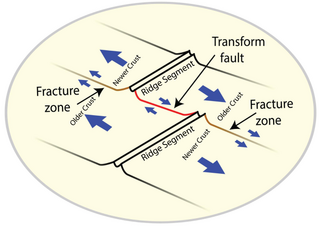
A fracture zone is a linear feature on the ocean floor—often hundreds, even thousands of kilometers long—resulting from the action of offset mid-ocean ridge axis segments. They are a consequence of plate tectonics. Lithospheric plates on either side of an active transform fault move in opposite directions; here, strike-slip activity occurs. Fracture zones extend past the transform faults, away from the ridge axis; are usually seismically inactive, although they can display evidence of transform fault activity, primarily in the different ages of the crust on opposite sides of the zone.
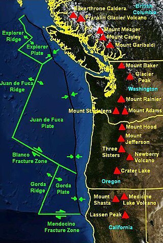
The Mendocino Fracture Zone is a fracture zone and transform boundary over 4000 km long, starting off the coast of Cape Mendocino in far northern California. It runs westward from a triple junction with the San Andreas Fault and the Cascadia subduction zone to the southern end of the Gorda Ridge. It continues on west of its junction with the Gorda Ridge, as an inactive remnant section which extends for several hundred miles.
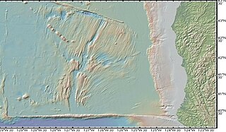
The Gorda Ridge, is a tectonic spreading center, located roughly 200 kilometres (120 mi) off the northern coast of California and southern Oregon. Running northeast to southwest, the region is roughly 300 kilometres (190 mi) in length. The ridge is broken into three segments: the northern ridge, central ridge, and the southern ridge, which includes the Escanaba Trough.

The Juan de Fuca Ridge is a mid-ocean spreading center and divergent plate boundary located off the coast of the Pacific Northwest region of North America, named after Juan de Fuca. The ridge separates the Pacific Plate to the west and the Juan de Fuca Plate to the east. It runs generally northward, with a length of approximately 500 kilometres (310 mi). The ridge is a section of what remains from the larger Pacific-Farallon Ridge which used to be the primary spreading center of this region, driving the Farallon Plate underneath the North American Plate through the process of plate tectonics. Today, the Juan de Fuca Ridge pushes the Juan de Fuca Plate underneath the North American plate, forming the Cascadia Subduction Zone.

The Explorer Ridge is a mid-ocean ridge, a divergent tectonic plate boundary located about 241 km (150 mi) west of Vancouver Island, British Columbia, Canada. It lies at the northern extremity of the Pacific spreading axis. To its east is the Explorer plate, which together with the Juan de Fuca plate and the Gorda plate to its south, is what remains of the once-vast Farallon plate which has been largely subducted under the North American plate. The Explorer Ridge consists of one major segment, the Southern Explorer Ridge, and several smaller segments. It runs northward from the Sovanco Fracture Zone to the Queen Charlotte triple junction, a point where it meets the Queen Charlotte Fault and the northern Cascadia subduction zone.

The geology of the Pacific Northwest includes the composition, structure, physical properties and the processes that shape the Pacific Northwest region of North America. The region is part of the Ring of Fire: the subduction of the Pacific and Farallon Plates under the North American Plate is responsible for many of the area's scenic features as well as some of its hazards, such as volcanoes, earthquakes, and landslides.
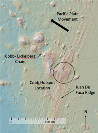
The Cobb hotspot is a marine volcanic hotspot at, which is 460 km (290 mi) west of Oregon and Washington, North America, in the Pacific Ocean. Over geologic time, the Earth's surface has migrated with respect to the hotspot through plate tectonics, creating the Cobb–Eickelberg Seamount chain. The hotspot is currently collocated with the Juan de Fuca Ridge.
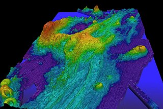
Axial Seamount is a seamount, submarine volcano, and underwater shield volcano in the Pacific Ocean, located on the Juan de Fuca Ridge, approximately 480 km (298 mi) west of Cannon Beach, Oregon. Standing 1,100 m (3,609 ft) high, Axial Seamount is the youngest volcano and current eruptive center of the Cobb–Eickelberg Seamount chain. Located at the center of both a geological hotspot and a mid-ocean ridge, the seamount is geologically complex, and its origins are still poorly understood. Axial Seamount is set on a long, low-lying plateau, with two large rift zones trending 50 km (31 mi) to the northeast and southwest of its center. The volcano features an unusual rectangular caldera, and its flanks are pockmarked by fissures, vents, sheet flows, and pit craters up to 100 m (328 ft) deep; its geology is further complicated by its intersection with several smaller seamounts surrounding it.
The Queen Charlotte triple junction is a geologic triple junction where three tectonic plates meet: the Pacific plate, the North American plate, and the Explorer plate. The three plate boundaries which intersect here are the Queen Charlotte Fault, the northern Cascadia subduction zone, and the Explorer Ridge. The Queen Charlotte triple junction is currently positioned adjacent to the Queen Charlotte Sound near the Dellwood Knolls off the coast of Vancouver Island. 10 Ma to 1.5 Ma prior to the triple junction's current location, it was located southwest of Vancouver Island The movements of the triple junction have been characterized by two major shifts in the Pacific-North American Tertiary plate tectonic record. First, at approximately 40 Ma the relative plate motions switched from orthogonal convergence to right-lateral strike slip. The variance in location of the triple junction may have also been related to the formation of an independent basin block. This formation could have been produced by fore-arc bending of the Pacific plate, due to oblique underthrusting prior to 1 Ma which produced stresses sufficient to break the Pacific plate and isolate the block. Transpression of 15–30 mm/yr since 5 Ma has been taking place, as well as varying amounts of both transpression and transtension occurring before then. To the northwest of the triple junction the Pacific plate currently has 15 degrees of oblique convergence, passing under the North American plate along the Queen Charlotte transform fault zone. The Explorer plate is a small chunk of the Juan de Fuca plate that broke away from the Juan de Fuca plate about 3.5 Ma and has moved much slower with respect to North America.
This is a list of articles related to plate tectonics and tectonic plates.
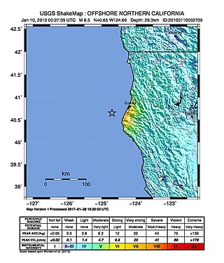
The 2010 Eureka earthquake occurred on January 9 at 4:27:38 pm PST offshore of Humboldt County, California, United States. The magnitude was measured 6.5 on the scale, and its epicenter was located offshore in the Pacific Ocean 33 miles (53 km) west of the nearest major city, Eureka. Additionally, there was a separate earthquake further offshore of Eureka on February 4 with a slightly lower magnitude of 5.9. It was also the most significant earthquake in the Eureka area in terms of magnitude since the 1992 Cape Mendocino earthquakes. It was felt from Santa Cruz County, California in the south, to Eugene, Oregon in the north and to the east as far as Reno, Nevada.

The Pacific Ocean evolved in the Mesozoic from the Panthalassic Ocean, which had formed when Rodinia rifted apart around 750 Ma. The first ocean floor which is part of the current Pacific plate began 160 Ma to the west of the central Pacific and subsequently developed into the largest oceanic plate on Earth.
The 1932 Eureka earthquake occurred on June 6 at along the northern coastal area of California in the United States. With a moment magnitude of 6.4 and a maximum Mercalli intensity of VIII (Severe), this earthquake left one person dead from a falling chimney and several injured. The shock was the largest in the area since 1923 and was felt in southern Oregon and northern California.
Cascadia Channel is the most extensive deep-sea channel currently known of the Pacific Ocean. It extends across Cascadia Abyssal Plain, through the Blanco Fracture Zone, and into Tufts Abyssal Plain. Notably, Cascadia Channel has tributaries, akin to river tributaries.


