
Dolna Banya Municipality is a municipality in Sofia Province, Bulgaria. It is best known for hosting Adolf Hitler on his roundabout tour of his captured dominions in 1942.
Pravo Bardo is a village in Petrich Municipality, in Blagoevgrad Province, Bulgaria.
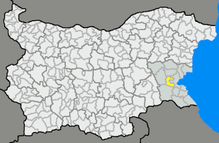
Kubadin is a village in Sredets Municipality, in Burgas Province, in southeastern Bulgaria.
Kalugerovo, Haskovo Province is a village in the municipality of Simeonovgrad, in Haskovo Province, in southern Bulgaria.
Knyazhevo is a village in the municipality of Topolovgrad, in Haskovo Province, in southern Bulgaria.

Topolica Sport Hall is a multi-purpose indoor,modern arena located in the city of Bar, Montenegro. It is the home ground of basketball club Mornar and has a capacity of 3000 spectators.
Kameno Municipality is a municipality in Burgas Province, Bulgaria. It includes the towns of Kameno and a number of villages.
Tsraklevtsi is a village in Dragoman Municipality, Sofia Province, western Bulgaria.
Kostino is a village in Kardzhali Municipality, Kardzhali Province, southern Bulgaria.
Kyosevo is a village in Kardzhali Municipality, Kardzhali Province, southern Bulgaria.
Zvunche is a village in Kardzhali Municipality, Kardzhali Province, southern Bulgaria.
Badino is a village in Boboshevo Municipality, Kyustendil Province, south-western Bulgaria.
Babinska Reka is a village in Bobov Dol Municipality, Kyustendil Province, south-western Bulgaria.
Dolistovo is a village in Bobov Dol Municipality, Kyustendil Province, south-western Bulgaria.
Shatrovo is a village in Bobov Dol Municipality, Kyustendil Province, south-western Bulgaria.
Delyan is a village in Dupnitsa Municipality, Kyustendil Province, south-western Bulgaria.
Cherven Breg is a village in Dupnitsa Municipality, Kyustendil Province, south-western Bulgaria.
Dolna Grashtitsa is a village in Kyustendil Municipality, Kyustendil Province, south-western Bulgaria.
Golyam izvor is a village in Teteven Municipality, Lovech Province, northern Bulgaria.
Slatina is a village in Lovech Municipality, Lovech Province, northern Bulgaria.


