
An apartment, flat, or unit is a self-contained housing unit that occupies part of a building, generally on a single storey. There are many names for these overall buildings. The housing tenure of apartments also varies considerably, from large-scale public housing, to owner occupancy within what is legally a condominium, to tenants renting from a private landlord.

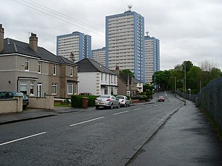
Scotstoun is an area of Glasgow, Scotland, west of Glasgow City Centre. It is bounded by Garscadden and Yoker to the west, Victoria Park, Jordanhill and Whiteinch to the east, Jordanhill to the north and the River Clyde to the south. At the heart of Scotstoun lies Scotstounhill, an enclave of late Victorian and post-war housing centred on Scotstounhill railway station. Scotstoun is home to BAE Systems Surface Ships, and to the Glasgow Warriors rugby team.

Toryglen is a district in southern Glasgow, Scotland, falling within the Langside ward under Glasgow City Council. It is approximately two miles south of the city centre, bounded to the west by Mount Florida, the north-west by Polmadie, to the north-east by the West Coast Main Line railway and the M74 motorway the south by King's Park, and immediately to the east by the town of Rutherglen.
Sandyhills is an area of the Scottish city of Glasgow. It is situated north of the River Clyde and has fallen within the Shettleston ward of Glasgow City Council since 2007.
Sighthill is a neighbourhood in the Scottish city of Glasgow. It is situated north of the River Clyde and is part of the wider Springburn district in the north of the city. It is bordered to the north by Cowlairs, to the east by the Springburn Bypass road and the Royston neighbourhood, to the west by the Glasgow to Edinburgh via Falkirk Line and to the south by the Townhead interchange of the M8 Motorway.
Hutchesontown is an inner-city area in Glasgow, Scotland. Mostly residential, it is situated directly south of the River Clyde and forms part of the wider historic Gorbals district, which is covered by the Southside Central ward under Glasgow City Council.

Laurieston is a district in the Gorbals area of the Scottish city of Glasgow. It is situated south of the River Clyde. It derives its name from James Laurie who, along with his brother, developed a large part of the district in the early 19th century.
The Bruce Report is the name commonly given to the First Planning Report to the Highways and Planning Committee of the Corporation of the City of Glasgow published in March 1945. It influenced an intensive programme of regeneration and rebuilding efforts which took place in the city and surroundings from the mid-1950s and lasted until the late 1970s. The author was Robert Bruce, Glasgow Corporation Engineer at the time.

Charing Cross is a major road junction and area within the centre of Glasgow, Scotland. It is situated north of the River Clyde at the intersection of Sauchiehall Street, St George's Road, Woodlands Road, North Street and Newton Street, as well as being at a major interchange of the M8 motorway. Charing Cross marks the notional boundary between the City Centre and the West End of the city.

The Red Road Flats were a mid-twentieth-century high-rise housing complex located between the districts of Balornock and Barmulloch in the northeast of the city of Glasgow, Scotland. The estate originally consisted of eight multi-storey blocks of steel frame construction. All were demolished by 2015. Two were "slabs", much wider in cross-section than they are deep. Six were "points", more of a traditional tower block shape. The slabs had 28 floors, the point blocks 31, and taken together, they were designed for a population of 4,700 people. The point blocks were among the tallest buildings in Glasgow at 89 metres (292 ft), second in overall height behind the former Bluevale and Whitevale Towers in Camlachie. The 30th floor of the point blocks were the highest inhabitable floor level of any building in Glasgow.

Duke Street is a major street in Glasgow, Scotland, and is of the major road arteries connecting the City Centre to the East End. It begins at High Street and runs east through the residential districts of Ladywell and Dennistoun, and on towards Haghill and Parkhead, meeting the Gallowgate, Tollcross Road and Westmuir Street to form a turreted Edwardian junction at Parkhead Cross. It takes its name from the Duke of Montrose. At a total distance of 2 miles (3.2km), Duke Street is the longest designated street in Glasgow.

The Sentinels are two 90 metre tall residential tower blocks on Holloway Head in Birmingham, England. The two towers, called Clydesdale Tower and Cleveland Tower, are both 31 storeys tall and were part of a major regeneration and council home building scheme following World War II which in the 1960s and 1970s saw the construction of hundreds of tower blocks. Originally built and operated by the City of Birmingham, the buildings were part of a stock transfer from Birmingham local authority to Optima Community Association in 1999, and today the buildings are owned by Citizen housing association. The Sentinels were the tallest purely residential tower blocks in the city until the completion of the 102 metre tall skyscraper Bank Tower 2 in 2019. They are also surpassed by the 132 metre tall residential tower known as The Mercian located on Broad Street with 42 floors.

Hutchesontown C was a Comprehensive Development Area (CDA) of an area of Hutchesontown, a district in the city of Glasgow, Scotland. Its centrepiece were two Brutalist 20-storey slab blocks at 16-32 Queen Elizabeth Square, designed by Sir Basil Spence and containing 400 homes. Acclaimed by architects and modernists, the flats became riddled with damp and infestations, which could not be cured even with a major renovation in the late 1980s. They were demolished in 1993, with the demolition contractor using twice the amount of explosive necessary to destroy the building, killing a female spectator in the process.

Glasgow, the largest city in Scotland, has several distinct styles of residential buildings. Building styles reflect historical trends, such as rapid population growth in the 18th and 19th centuries, deindustrialisation and growing poverty in the late 20th century, and civic rebound in the 21st century.

Glasgow Tower is a 127 metres (417 ft) free-standing landmark observation tower located on the south bank of the River Clyde in Glasgow, Scotland, and is part of the Glasgow Science Centre complex. It holds a Guinness World Record for being the tallest fully rotating freestanding structure in the world, in which the whole structure is capable of rotating 360 degrees.
The 1950s and 1960s saw the construction of numerous brutalist apartment blocks in Sheffield, England. The Sheffield City Council had been clearing inner-city residential slums since the early 1900s. Prior to the 1950s these slums were replaced with low-rise council housing, mostly constructed in new estates on the edge of the city. By the mid-1950s the establishment of a green belt had led to a shortage of available land on the edges of the city, whilst the government increased subsidies for the construction of high-rise apartment towers on former slum land, so the council began to construct high-rise inner city estates, adopting modernist designs and industrialised construction techniques, culminating in the construction of the award-winning Gleadless Valley and Park Hill estates.

St Andrew House is a mid-rise skyscraper in the centre of Glasgow, Scotland.

Elmbank Gardens is a multi-use commercial complex in the Charing Cross area of Glasgow, Scotland. Best known for its signature 13-storey tower which overlooks the M8 motorway and stands directly opposite the Mitchell Library, it was designed by Richard Seifert and constructed between 1970 and 1972. It is one of the tallest and most prominent high rise buildings on the western side of Glasgow city centre, beyond Blythswood Hill. The surface buildings of the subterranean railway station which serves Charing Cross are also an integral part of the complex.

Gallowgate is a neighbourhood of the city of Glasgow, Scotland. It takes its name from the major thoroughfare through the territory, which is part of the A89 road. Administratively, it is part of the Calton ward of the Glasgow City Council area.


