
The Mohawk River is a 149-mile-long (240 km) river in the U.S. state of New York. It is the largest tributary of the Hudson River. The Mohawk flows into the Hudson in Cohoes, New York, a few miles north of the city of Albany. The river is named for the Mohawk Nation of the Iroquois Confederacy. It is a major waterway in north-central New York.

The Cowlitz River is a river in the state of Washington in the United States, a tributary of the Columbia River. Its tributaries drain a large region including the slopes of Mount Rainier, Mount Adams, and Mount St. Helens.

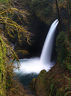
The Clackamas River is an approximately 83-mile (134 km) tributary of the Willamette River in northwestern Oregon, in the United States. Draining an area of about 940 square miles (2,435 km2), the Clackamas flows through mostly forested and rugged mountainous terrain in its upper reaches, and passes agricultural and urban areas in its lower third. The river rises in eastern Marion County, about 55 miles (89 km) east-southeast of Salem. The headwaters are on the slopes of Olallie Butte in the Mount Hood National Forest, about 10 miles (16 km) north of Mount Jefferson, at an elevation of 4,909 feet (1,496 m) in the Cascade Range. The Clackamas flows briefly north and then flows northwest through the mountains, passing through North Fork Reservoir and Estacada. It then emerges from the mountains southeast of Portland. It joins the Willamette near Oregon City and forms the boundary between Oregon City and Gladstone.
The Chehalis River is located in the southwest corner of British Columbia, Canada near the city of Chilliwack. It flows south-eastward out of the Douglas Ranges of the Coast Mountains, draining into the Harrison River.
Eagle Creek is a creek located in Hood River County, Oregon, in the Columbia River Gorge. A tributary of the Columbia River, the creek flows for approximately 15 miles (24 km) from the Thrush Pond between Eagle Butte and Tanner Butte to its mouth near Bonneville Dam. The East Fork Eagle Creek is a major tributary that begins at Wahtum Lake and joins the main stem approximately 2/3 the way between the Thrush Pond and the Columbia River, separated by Indian Mountain.

The Barron River is located on the Atherton Tablelands inland from Cairns in northern Queensland, Australia. With its headwaters below Mount Hypipamee, the 165-kilometre (103 mi)-long river with a catchment area of approximately 2,138 square kilometres (825 sq mi) forms through run off from the Mount Hypipamee National Park, flows through Lake Tinaroo, and eventually empties into the Coral Sea near Smithfield.

The Cispus River is about 54 miles (87 km) long and flows into the Cowlitz River at Lake Scanewa in the Cascade Range of Washington. Its tributaries drain most of south-central and southeastern Lewis County, extreme northeast Skamania County, and some of western Yakima County.

The Hay River is a large river in northern Alberta and southern Northwest Territories, Canada.
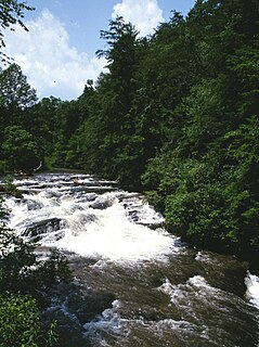
The Soque River and its watershed are located entirely within the county boundaries of Habersham County in northeast Georgia. The Soque is a tributary of the Chattahoochee River. Portions of the river run along State Route 197.

The Klamath Basin is the region in the U.S. states of Oregon and California drained by the Klamath River. It contains most of Klamath County and parts of Lake and Jackson counties in Oregon, and parts of Del Norte, Humboldt, Modoc, Siskiyou, and Trinity counties in California. The 15,751-square-mile (40,790 km2) drainage basin is 35% in Oregon and 65% in California. In Oregon, the watershed typically lies east of the Cascade Range, while California contains most of the river's segment that passes through the mountains. In the Oregon-far northern California segment of the river, the watershed is semi-desert at lower elevations and dry alpine in the upper elevations. In the western part of the basin, in California, however, the climate is more of temperate rainforest, and the Trinity River watershed consists of a more typical alpine climate.
Brandywine Creek, also formerly known as the Long John River after a local prospector and trapper, is a tributary of the Cheakamus River in the Pacific Ranges of the Coast Mountains in British Columbia, Canada, entering that stream via Daisy Lake, just below Brandywine Falls. The creek is about 14 km in length and originates on the south slope of Brandywine Mountain in Brandywine Meadows, at the southern end of the Powder Mountain Icefield and is the next basin immediately southwest of that of the Callaghan Valley, the site of the Nordic events facility for the 2010 Olympics. The creek's valley has been partially logged. An unnamed hot spring lies in its upper reaches, near Mount Fee.

The Priest River is a 68-mile (109 km) long tributary of the Pend Oreille River in the U.S. state of Idaho. It is part of the Columbia River basin, as the Pend Oreille River is a tributary of the Columbia River. The river's drainage basin is 980 square miles (2,500 km2) in area.
Blum Basin Falls is a waterfall in Whatcom County, in the U.S. state of Washington. It is located in North Cascades National Park on the headwaters of Blum Creek, a tributary of the Baker River. Fed by two small retreating glaciers and several snowfields on the southern side of Mount Blum, the waterfall is formed by the largest meltwater stream that feeds the mainstem of Blum Creek. The falls tumble 1,680 feet (510 m) down a high glacial headwall several miles within the national park in two distinct stages; the first is a series of slides over rounded rock, above the tree line, and the second is a series of near-vertical plunges to the forested valley below. Although most of the falls is clearly visible, parts of it are obscured by tall pines that grow at its base. There is no trail leading to the waterfall.
Blum Creek is a small glacial tributary of the Baker River in Washington State, in the United States. It is sourced from the Hagan Glacier and another unnamed glacier on the north face of Mount Blum, and flows approximately 1.5 miles (2.4 km) from there to its mouth at the Baker River. Hagan Glacier is located below Mount Blum and the creek is also fed by runoff from the Blum Lakes, a set of six lakes south of Bacon Peak. The creek joins the Baker River two drainages downstream of Sulphide Creek, another Baker River glacial tributary. Blum Creek forms the waterfall Blum Basin Falls as it tumbles down a 1,680-foot (510 m) glacial cliff. The creek's watershed is an overwintering location for the local Rocky mountain goats.

Sulphide Creek is a 2.5-mile (4.0 km) glacial tributary of the Baker River in Whatcom County in the U.S. state of Washington, draining a steep and narrow canyon on the southeast flank of Mount Shuksan, inside North Cascades National Park. Although called a creek, it is river-like due to its high volume. The creek is fed by the "massive" Sulphide and Crystal glaciers above Sulphide Lake and it runs east collecting several small tributaries before flowing into the Baker River at elevation 869 feet (265 m). There are several very tall waterfalls occurring on the creek and its tributaries, the largest of which is Sulphide Creek Falls.
The Tye River is a river in the U.S. state of Washington. It rises near Stevens Pass in the Cascade Mountains and flows west, joining the Foss River to form the South Fork Skykomish River. Its waters eventually empty into Puget Sound near Everett via the Skykomish River and Snohomish River. U.S. Route 2 follows the river's entire length. A BNSF Railway line follows most of the river except near the pass where the tracks use the Cascade Tunnel. Powerlines run by the Bonneville Power Administration (BPA) follow the Tye River west of Tunnel Creek.

The Big River, a perennial river of the North-East Murray catchment of the Murray-Darling basin, is located in the East Gippsland and alpine regions of Victoria, Australia. It flows from the northern slopes of Falls Creek in the Australian Alps, joining with the Cobungra River near Anglers Rest to form the Mitta Mitta River.
Sulphide Lake is located in North Cascades National Park, in the U. S. state of Washington. Sulphide Lake lies in a cirque on the southeast slopes of Mount Shuksan. Several major cascades drop as much as 1,000 ft (300 m) into Sulphide Lake including Sulphide Basin Falls which is from melt off the Sulphide Glacier. After Sulphide Creek drains from Sulphide lake, it then plunges at least 2,000 ft (610 m) over a series of cascades called Sulphide Creek Falls, which is one of the tallest waterfalls in the U.S.

The Black River is a river in Cochrane District and Timiskaming District in Northeastern Ontario, Canada. It is part of the James Bay drainage basin, and is a right tributary of the Abitibi River. The municipality of Black River-Matheson is named after the river.


