Related Research Articles

The Salmon River, also known as "The River of No Return", is a river located in the U.S. state of Idaho in the western United States. It flows for 425 miles (685 km) through central Idaho, draining a rugged, thinly populated watershed of 14,000 square miles (36,000 km2). The river drops more than 7,000 feet (2,100 m) from its headwaters, near Galena Summit above the Sawtooth Valley in the Sawtooth National Recreation Area, to its confluence with the Snake River. Measured at White Bird, its average discharge is 11,060 cubic feet per second. It is one of the largest rivers in the continental United States without a single dam on its mainstem.

Little Redfish Lake is a name given to two different alpine lakes in central Idaho, both in the Sawtooth National Recreation Area and Custer County. This article refers to the lake on Redfish Lake Creek downstream of Redfish Lake and south of Stanley. For the article on the other Little Redfish Lake see Little Redfish Lake.

Boise National Forest is a National Forest covering 2,203,703 acres (8,918.07 km2) of the U.S. state of Idaho. Created on July 1, 1908, from part of Sawtooth National Forest, it is managed by the U.S. Forest Service as five units: the Cascade, Emmett, Idaho City, Lowman, and Mountain Home ranger districts.

The Sawtooth Wilderness is a federally-protected wilderness area that covers 217,088 acres (87,852 ha) of the state of Idaho. Managed by the U.S. Forest Service in the U.S. Department of Agriculture, it was designated the Sawtooth Primitive Area in 1937 to preserve the exceptional scenic beauty of the Sawtooth Mountains. On August 22, 1972 Public Law 92-400 designated the Primitive Area as the Sawtooth Wilderness and part of the newly created Sawtooth National Recreation Area. As part of the National Wilderness Preservation System, the Sawtooth Wilderness is an area where human development and use are restricted and people are to remain only visitors. According to the United States Environmental Protection Agency, the Sawtooth Wilderness has some of the clearest air in the lower 48 states.

Sawtooth National Forest is a National Forest that covers 2,110,408 acres in the U.S. states of Idaho and Utah. Managed by the U.S. Forest Service in the U.S. Department of Agriculture, it was originally named the Sawtooth Forest Reserve in a proclamation issued by President Theodore Roosevelt on May 29, 1905. On August 22, 1972 a portion of the forest was designated as the Sawtooth National Recreation Area (SNRA), which includes the Sawtooth, Cecil D. Andrus–White Clouds, and Hemingway–Boulders wilderness areas. The forest is managed as four units: the SNRA and the Fairfield, Ketchum, and Minidoka Ranger Districts.

The Sawtooth National Recreation Area (SNRA) is a national recreation area in central Idaho, United States that is managed as part of Sawtooth National Forest. The recreation area, established on August 22, 1972, is managed by the U.S. Forest Service, and includes the Sawtooth, Hemingway–Boulders, and Cecil D. Andrus–White Clouds wilderness areas. Activities within the 730,864-acre (2,957.70 km2) recreation area include hiking, backpacking, White water rafting, camping, rock climbing, kayaking, mountain biking, fishing, and hunting.

The Middle Fork of the Salmon River is a 104-mile-long (167 km) river in central Idaho in the northwestern United States. It is a tributary to the Salmon River, and lies in the center of the 2.5-million-acre Frank Church-River of No Return Wilderness Area.
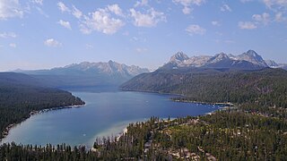
Redfish Lake is an alpine lake in Custer County, Idaho, just south of Stanley. It is the largest lake within the Sawtooth National Recreation Area.

Mount Heyburn, at 10,229 feet (3,118 m) is one of the many 10,000-foot (3,050 m) peaks in the Sawtooth Range of central Idaho. Mount Heyburn is located in Custer County and within the Sawtooth Wilderness portion of the Sawtooth National Recreation Area. The town of Stanley is located eight miles (13 km) north-northeast of Mount Heyburn. Grand Mogul, 9,733 ft (2,967 m), and Mount Heyburn are the two signature peaks that frame the southwest end of Redfish Lake ; all are in the Salmon River watershed.

The White Cloud Mountains are part of the Rocky Mountains of the western United States, located in central Idaho, southeast of Stanley in Custer County. The range is located within the Sawtooth National Recreation Area (SNRA) and partially within the Cecil D. Andrus–White Clouds Wilderness.
Stanley Lake is an alpine lake in the western United States, located in Custer County, Idaho, at the base of the Sawtooth Mountains in the Sawtooth National Recreation Area.
State Highway 21 (SH-21) is the Ponderosa Pine Scenic Byway, primarily a two-lane highway from Boise to Stanley. With two-thirds of its length in Boise County, it passes by historic Idaho City and the village of Lowman to the western edge of the Sawtooth Mountains, then along their northern boundary to Stanley.

The South Fork McKenzie River is a tributary, about 31 miles (50 km) long, of the McKenzie River in the U.S. state of Oregon. It begins at about 4,500 feet (1,400 m) above sea level near Mink Lake in the Three Sisters Wilderness of the Cascade Range. Flowing northwest within Lane County, it meets the McKenzie River about 60 miles (97 km) from the larger river's confluence with the Willamette River.
Sloquet Hot Springs is a hot spring 100 km (62 mi) south east of Pemberton and Whistler in British Columbia, Canada along the in-SHUCK-ch forest service road and is located in the traditional First Nations community of Xa'xtsa or Douglas First Nation in the community of Tipella, at 78.5 km (48.8 mi) along the in-SHUCK-ch forest service road.
The Idaho Hot Springs Mountain Bike Route is an off-road bicycle touring route in central Idaho. Developed by Adventure Cycling Association, the route consists of 518 miles of mostly dirt roads and 227 miles of optional singletrack, with access to more than 50 hot springs.

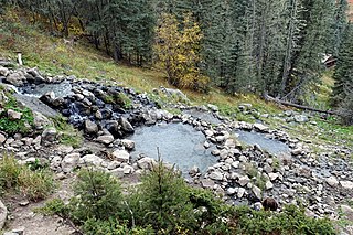
Goldbug Hot Springs is a hot spring located in the Salmon-Challis National Forest about 20 miles south of Salmon, Idaho. The spring is along Warm Spring Creek and there are about six waterfall-fed pools. Goldbug is listed as having a temperature of 113 °F (45 °C), but the temperature of the pools will vary depending on the time of year. The pools have a sand/gravel bottom and are dammed by boulders. Due to the hike and remoteness of the trailhead, it is not usually crowded.
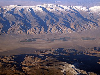
Fish Lake Hot Well, also known as Fish Lake Hot Spring and Fish Lake Valley Hot Well is a geothermal hot spring in Nevada.
San Antionio Hot Springs are a group of geothermal springs located in the Santa Fe National Forest in Northern New Mexico.
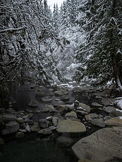
Frenchman's Hot Springs, also known as Frenchman's Bend Hot Springs or Warfield Hot Springs, is a hot spring located along Warm Springs Creek in the Sawtooth National Forest, 11 miles (17.7km) from Ketchum, Idaho. The springs are composed of three wide, shallow pools. The pools are rock-walled, with sand and gravel covered bottoms. The average temperature of the springs varies throughout the year, but most of the time, water enters the springs at around 124°F (51.11°C). The water in the springs is usually clear.
References
- 1 2 Emily Mandagie (10 August 2020). "BOAT BOX HOT SPRINGS" . Retrieved December 29, 2021.
- 1 2 3 4 "Idaho Hot Springs: Elkhorn (Boat Box)" . Retrieved December 29, 2021.
- 1 2 Berry, George W.; Grim, Paul J.; Ikelman, Joy A. (1980). Thermal Spring List for the United States. Boulder, Colorardo: National Oceanic and Atmospheric Administration. p. 23.
- 1 2 Denis LeBlanc. "Boat Box Hot Spring" . Retrieved December 29, 2021.
- ↑ "Places to go, things to see - Stanley, Idaho (summer)" . Retrieved December 29, 2021.
- ↑ Matt Gross (February 28, 2019). "Idaho's Hidden Hot Springs Will Simmer Away Reality". Bloomberg News . Retrieved December 29, 2021.
- ↑ "Riparian and Wetland". United States Forest Service. Retrieved December 29, 2021.
- ↑ Makovsky, Kyle; Mink, Leland "Roy"; Beckwith, Robert. "Stanley Geothermal Feasibility Study Task 3 Report: Temperature Logging and Chemical Geothermometer Analysis" (PDF). Boise State University. Retrieved 31 December 2021.
- ↑ Welhan, John Andrew; Autenrieth, Kathleen (January 2012). "Preliminary Characterization of the Geothermal Systemat Stanley, Idaho, for Possible Resource Utilization". Transactions: Geothermal Resources Council. 36. Retrieved 31 December 2021.
- ↑ "Stanley, Idaho". Western Regional Climate Center. Retrieved 2017-03-27.