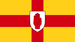
Ulster is one of the four traditional Irish provinces. It is made up of nine counties: six of these constitute Northern Ireland ; the remaining three are in the Republic of Ireland.

The Plantation of Ulster was the organised colonisation (plantation) of Ulster – a province of Ireland – by people from Great Britain during the reign of King James I. Most of the settlers came from southern Scotland and northern England; their culture differed from that of the native Irish. Small privately funded plantations by wealthy landowners began in 1606, while the official plantation began in 1609. Most of the colonised land had been confiscated from the native Gaelic chiefs, several of whom had fled Ireland for mainland Europe in 1607 following the Nine Years' War against English rule. The official plantation comprised an estimated half a million acres (2,000 km2) of arable land in counties Armagh, Cavan, Fermanagh, Tyrone, Donegal, and Londonderry. Land in counties Antrim, Down, and Monaghan was privately colonised with the king's support.
A townland is a small geographical division of land, historically and currently used in Ireland and in the Western Isles in Scotland, typically covering 100–500 acres (40–202 ha). The townland system is of Gaelic origin, pre-dating the Norman invasion, and most have names of Irish origin. However, some townland names and boundaries come from Norman manors, plantation divisions, or later creations of the Ordnance Survey. The total number of inhabited townlands in Ireland was 60,679 in 1911. The total number recognised by the Irish Place Names database as of 2014 was 61,098, including uninhabited townlands, mainly small islands.

Plantations in 16th- and 17th-century Ireland involved the confiscation of Irish-owned land by the English Crown and the colonisation of this land with settlers from Great Britain. The Crown saw the plantations as a means of controlling, anglicising and 'civilising' Gaelic Ireland. The main plantations took place from the 1550s to the 1620s, the biggest of which was the plantation of Ulster. The plantations led to the founding of many towns, massive demographic, cultural and economic changes, changes in land ownership and the landscape, and also to centuries of ethnic and sectarian conflict. They took place before and during the earliest English colonisation of the Americas, and a group known as the West Country Men were involved in both Irish and American colonization.

Scottish or Scots units of measurement are the weights and measures peculiar to Scotland which were nominally replaced by English units in 1685 but continued to be used in unofficial contexts until at least the late 18th century. The system was based on the ell (length), stone (mass), and boll and firlot (volume). This official system coexisted with local variants, especially for the measurement of land area.
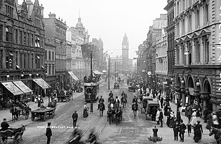
Belfast is the capital of Northern Ireland, and throughout its modern history has been a major commercial and industrial centre. In the late 20th century manufacturing industries that had existed for several centuries declined, particularly shipbuilding. The city's history has occasionally seen conflict between different political factions who favour different political arrangements between Ireland and Great Britain. Since the Good Friday Agreement, the city has been relatively peaceful and major redevelopment has occurred, especially in the inner city and dock areas.

The Down Survey was a cadastral survey of Ireland, carried out by English scientist, William Petty, in 1655 and 1656.

Northern Ireland is divided into six counties, namely: Antrim, Armagh, Down, Fermanagh, Londonderry and Tyrone. Six largely rural administrative counties based on these were among the eight primary local government areas of Northern Ireland from its 1921 creation until 1973. The other two local government areas were the urban county boroughs of Derry and Belfast.

Protestantism is a Christian minority on the island of Ireland. In the 2011 census of Northern Ireland, 48% (883,768) described themselves as Protestant, which was a decline of approximately 5% from the 2001 census. In the 2011 census of the Republic of Ireland, 4.27% of the population described themselves as Protestant. In the Republic, Protestantism was the second largest religious grouping until the 2002 census in which they were exceeded by those who chose "No Religion". Some forms of Protestantism existed in Ireland in the early 16th century before the English Reformation, but demographically speaking these were very insignificant and the real influx of Protestantism began only with the spread of the English Reformation to Ireland. The Church of Ireland was established by King Henry VIII of England, who had himself proclaimed as King of Ireland.

O'Doherty's rebellion took place in 1608 when Sir Cahir O'Doherty, lord of Inishowen, began an uprising against the Crown authorities in the west of Ulster in the north-west of the Kingdom of Ireland. O'Doherty, a Gaelic chieftain, had been a long-standing supporter of the Crown, but having been angered at his treatment by local officials he launched an attack on Derry, burning the town. O'Doherty may have hoped to negotiate a settlement with the government, but, after his death in a skirmish at Kilmacrennan, the rebellion collapsed with the last survivors being besieged on Tory Island.

Derrintony is a townland in the Civil Parish of Tomregan, Barony of Knockninny, County Fermanagh, Northern Ireland.
Garvary is a townland in the Civil Parish of Tomregan, Barony of Knockninny, County Fermanagh, Northern Ireland. (Disambiguation- see also Garvary townland, County Cavan, Republic of Ireland.)

Gortmullan is a townland in the Civil Parish of Tomregan, Barony of Knockninny, County Fermanagh, Northern Ireland.
Knockateggal is a townland in the Civil Parish of Tomregan, Barony of Knockninny, County Fermanagh, Northern Ireland.
Ulster Protestants are an ethnoreligious group in the Irish province of Ulster, where they make up about 43% of the population. Most Ulster Protestants are descendants of settlers who arrived from Britain in the early 17th century Ulster Plantation. This was the settlement of the Gaelic, Catholic province of Ulster by Scots and English speaking Protestants, mostly from the Scottish Lowlands and Northern England. Many more Scottish Protestant migrants arrived in Ulster in the late 17th century. Those who came from Scotland were mostly Presbyterians, while those from England were mostly Anglicans. There is also a small Methodist community and the Methodist Church in Ireland dates to John Wesley's visit to Ulster in 1752. Although most Ulster Protestants descend from Lowland Scottish people and English, some also descend from Irish, Welsh and Huguenots.
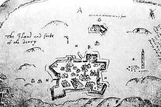
The Burning of Derry took place on 19 April 1608 during O'Doherty's Rebellion when Sir Cahir O'Doherty led a force of rebels to storm Derry in Ulster. He launched his rebellion with an attack on the garrison town of Derry, which was taken thanks to the element of surprise. The town was then almost entirely destroyed by fire.
Sir Josias Bodley (1550-1618) was an English military engineer noted for his service in Ireland during the Nine Years' War. Following the end of the war he remained in Ireland where he oversaw the rebuilding of several major forts. In 1609 he was entrusted with the Bodley Survey which mapped out terrain for the Ulster Plantation.
Henry Hart (1566-1637) was an Anglo-Irish soldier and landowner of the Elizabethan and early Stuart eras. He served in the Nine Years' War (1584-1603) and was later involved in the opening incident of O'Doherty's Rebellion in 1608. As a servitor he acquired an estate in County Donegal.
The Peyton Survey was a 1584 cadastral survey overseen by Christopher Peyton which mapped out areas of the province of Munster in the Kingdom of Ireland.

Irish measure or plantation measure was a system of units of land measurement used in Ireland from the 16th century plantations until the 19th century, with residual use into the 20th century. The units were based on "English measure" but used a linear perch measuring 7 yards (6.4 m) as opposed to the English rod of 5.5 yards (5.0 m). Thus, linear units such as the furlong and mile, which were defined in terms of perches, were longer by a factor of 14:11 in Irish measure, while areas such as the rood or acre were larger by 196:121. After the Act of Union 1800, Ireland was part of the United Kingdom of Great Britain and Ireland, whose Parliament passed the Weights and Measures Act 1824, which established English measure in Ireland as "Imperial measure" or "statute measure". Imperial measure soon replaced Irish measure in the use of the Irish Government, but Irish measure persisted in local government, and longer still in private use.
