Related Research Articles

The Columbia Basin Project in Central Washington, United States, is the irrigation network that the Grand Coulee Dam makes possible. It is the largest water reclamation project in the United States, supplying irrigation water to over 670,000 acres (2,700 km2) of the 1,100,000 acres (4,500 km2) large project area, all of which was originally intended to be supplied and is still classified irrigable and open for the possible enlargement of the system. Water pumped from the Columbia River is carried over 331 miles (533 km) of main canals, stored in a number of reservoirs, then fed into 1,339 miles (2,155 km) of lateral irrigation canals, and out into 3,500 miles (5,600 km) of drains and wasteways. The Grand Coulee Dam, powerplant, and various other parts of the CBP are operated by the Bureau of Reclamation. There are three irrigation districts in the project area, which operate additional local facilities.
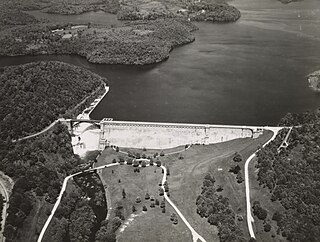
The New Croton Dam is a dam forming the New Croton Reservoir, both parts of the New York City water supply system. It stretches across the Croton River near Croton-on-Hudson, New York, about 22 miles (35 km) north of New York City.

San Luis Dam, also known as B.F. Sisk Dam, is a major earth-filled dam in Merced County, California, which forms San Luis Reservoir, the largest off-stream reservoir in the United States. The dam and reservoir are located in the Diablo Range to the east of Pacheco Pass and about 10 miles (16 km) west of Los Banos. San Luis Dam, a jointly-owned state and federal facility, stores more than 2 million acre feet (2.5 km3) of water for the California State Water Project and the federal Central Valley Project. Although the dam is located in the valley of San Luis Creek, the majority of its water comes from man-made aqueducts which are supplied from other rivers in Northern California.

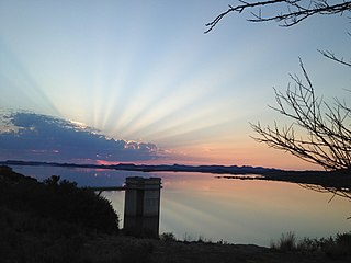
The Gariep Dam is located in South Africa, near the town of Norvalspont, bordering the Free State and Eastern Cape provinces. Its primary purpose is for irrigation, domestic and industrial use as well as for power generation. It the largest dam in South Africa.

Malampuzha Dam is the second largest dam and reservoirs in Kerala, located near Palakkad, in the state of Kerala in South India, built post independence by the then Madras state. Situated in the scenic hills of the Western Ghats in the background it is a combination of a masonry dam with a length of 1,849 metres and an earthen dam with a length of 220 metres making it the longest dam in the state. The dam is 355 feet high and impounds the Malampuzha River, a tributary of Bharathappuzha, Kerala's second longest river. There is a network of two canal systems that serve the dam's reservoir of 42,090 hectares.

Sir William Willcocks was a British civil engineer during the high point of the British Empire. He was an irrigation engineer who proposed and built the first Aswan Dam, the scale of which had never been attempted previously. He later undertook other major irrigation projects in South Africa and in Arab regions of the dying Ottoman Empire.

Ujjani Dam, also known as Bhima Dam or Bhima Irrigation Project, on the Bhima River, a tributary of the Krishna River, is an earthfill cum Masonry gravity dam located near Ujjani village of Madha Taluk in Solapur district of the state of Maharashtra in India.

Buffalo Bill Dam is a concrete arch-gravity dam on the Shoshone River in the U.S. state of Wyoming. Originally 325-foot (99 m), it was the tallest dam in the world when it opened in 1910; a 25-foot (7.6 m) extension was added in 1992 in one of numerous changes and improvements to the structure and its support facilities, which include two full time power generators and two seasonal operations added between 1920 and 1994, and a 2.8-mile (4.5 km) irrigation tunnel completed in 1939.

Kakamas is a town founded in 1898 and located in the Northern Cape province of South Africa, on the banks of the Orange River.
The Orange–Fish Tunnel, constructed between 1966 and 1975, is an 82.8-kilometre (51.4-mile) long irrigation tunnel in central South Africa, built to divert water from the Orange River to the Fish River valley. It is the longest continuous enclosed aqueduct in the southern hemisphere.

Interbasin transfer or transbasin diversion are terms used to describe man-made conveyance schemes which move water from one river basin where it is available, to another basin where water is less available or could be utilized better for human development. The purpose of such water resource engineering schemes can be to alleviate water shortages in the receiving basin, to generate electricity, or both. Rarely, as in the case of the Glory River which diverted water from the Tigris to Euphrates River in modern Iraq, interbasin transfers have been undertaken for political purposes. While ancient water supply examples exist, the first modern developments were undertaken in the 19th century in Australia, India and the United States, feeding large cities such as Denver and Los Angeles. Since the 20th century many more similar projects have followed in other countries, including Israel and China, and contributions to the Green Revolution in India and hydropower development in Canada.

Oviston Nature Reserve is a protected area in the Eastern Cape Province, South Africa. The nature reserve is managed by Eastern Cape Parks. It is located on the southern shores of the Gariep Dam.
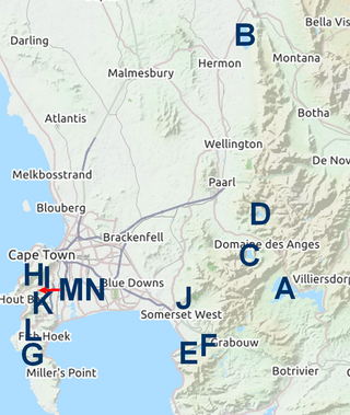
The Western Cape Water Supply System (WCWSS) is a complex water supply system in the Western Cape region of South Africa, comprising an inter-linked system of six main dams, pipelines, tunnels and distribution networks, and a number of minor dams, some owned and operated by the Department of Water and Sanitation and some by the City of Cape Town.

The Berg River Dam is a 68-metre (223 ft) high dam on the Berg River in South Africa. It is the centerpiece of the Berg Water Project (BWP) which is designed to capture the winter rainfall and store it for supply to Cape Town during the dry summer months. The project in turn forms an important part of the Western Cape Water Supply System (WCWSS), an intricate system of dams and bulk water infrastructure that provides water to more than 3 million people. At the inauguration of the dam in 2009, then President of South Africa Kgalema Motlanthe called the project "a good example of how public infrastructure projects can be used to contribute meaningfully to poverty eradication and to foster social empowerment of the people." The Berg River Dam was the first dam in South Africa to be designed and constructed in accordance with the guidelines of the World Commission on Dams. It has been completed on time and within budget. The Berg River basin and the adjacent metropolitan area of Cape Town are of particular importance to the Western Cape region because, although the basin generates only about 3% of the country's water resources, it is home to about 8% of South Africa's population, and produces about 12% of GDP.
Boskop Dam is an earth-fill type dam on the Mooi River, near Potchefstroom, North West Province, South Africa. It was constructed in 1959. The main purpose of the dam is for irrigation and domestic usage. Its hazard potential is ranked as high, due to poor maintenance and the development of sink holes.

Darlington Dam, also referred to as Lake Mentz, is a gravity type dam situated in the Addo Elephant National Park confining the Sundays River, near Kirkwood, in the Eastern Cape, South Africa.
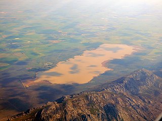
Voëlvlei Dam is a dam located in the Western Cape, South Africa near the town of Gouda. The earth-fill wall is 2,910 metres (9,550 ft) long and 10 metres (33 ft) high. The reservoir covers an area of 1,524 hectares and has a capacity of 168,000 megalitres, making it the second-largest reservoir in the Western Cape Water Supply System. Water from the reservoir is supplied to water treatment works of the City of Cape Town and the West Coast District Municipality, and can also be released into the Berg River for agricultural purposes or to fill the Misverstand Dam.

The Tungabhadra Dam, also known as Pampa Sagar, is a water reservoir constructed across the Tungabhadra River in the Hosapete-Koppal confluence in Karnataka, India. It is a multipurpose dam serving irrigation, electricity generation, flood control, etc. for the state. It is India's largest stone masonry dam and one of the only two non-cement dams in the country, the other being the Mullaperiyar Dam in Kerala. The dam is built of surki mortar, a combination of mud and limestone, commonly used at the time of its construction.
The Vaalharts Valley is located in the north-east corner of the Northern Cape province of South Africa, bordering the North West province. It gets its name because it is located between two rivers, the Vaal and the Harts. Because of its advantageous position between the two rivers, an irrigation scheme was built in the Vaalharts Valley in the 1930s.
References
- List of South African Dams from the South African Department of Water Affairs