Cape Town is the second-most populous city in South Africa, after Johannesburg, and also the legislative capital of South Africa.

Table Bay is a natural bay on the Atlantic Ocean overlooked by Cape Town and is at the northern end of the Cape Peninsula, which stretches south to the Cape of Good Hope. It was named because it is dominated by the flat-topped Table Mountain.

Khoekhoen are the traditionally nomadic pastoralist indigenous population of southwestern Africa. They are often grouped with the hunter-gatherer San peoples. The designation "Khoekhoe" is actually a kare or praise address, not an ethnic endonym, but it has been used in the literature as an ethnic term for Khoe-speaking peoples of Southern Africa, particularly pastoralist groups, such as the !Ora, !Gona, Nama, Xiri and ǂNūkhoe nations.

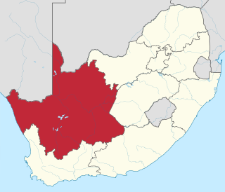
The Northern Cape is the largest and most sparsely populated province of South Africa. It was created in 1994 when the Cape Province was split up. Its capital is Kimberley. It includes the Kalahari Gemsbok National Park, part of the Kgalagadi Transfrontier Park and an international park shared with Botswana. It also includes the Augrabies Falls and the diamond mining regions in Kimberley and Alexander Bay.

Cape York Peninsula is a large peninsula located in Far North Queensland, Australia. It is the largest unspoiled wilderness in northern Australia. The land is mostly flat and about half of the area is used for grazing cattle. The relatively undisturbed eucalyptus-wooded savannahs, tropical rainforests and other types of habitat are now recognized and preserved for their global environmental significance. Although much of the peninsula remains pristine, with a diverse repertoire of endemic flora and fauna, some of its wildlife may be threatened by industry and overgrazing as well as introduced species and weeds.

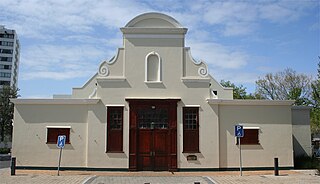
Upington is a town founded in 1873 and located in the Northern Cape province of South Africa, on the banks of the Orange River. The town was originally called Olijvenhoutsdrift, due to the abundance of olive wood trees in the area, but later renamed after Sir Thomas Upington, Attorney-General and then Prime Minister of the Cape. It originated as a mission station established in 1871 and run by Reverend Christiaan Schröder. The mission station now houses the town museum, known as the Kalahari Orange Museum. The museum is also the home of a donkey statue, which recognises the enormous contribution that this animal made to the development of the region during the pioneering days of the 19th century.

South Africa switched to a closed numbering system effective 16 January 2007. At that time, it became mandatory to dial the full 10-digit telephone number, including the zero in the three-digit area code, for local calls. Area codes within the system are generally organized geographically. All telephone numbers are 9 digits long, except for certain Telkom special services. When dialed from another country, the '0' is omitted and replaced with the appropriate international access code and the country code 27

Cape Tribulation is a headland and coastal locality in the Shire of Douglas in northern Queensland, Australia. In the 2016 census, Cape Tribulation had a population of 118 people.

Far North Queensland (FNQ) is the northernmost part of the Australian state of Queensland. Its largest city is Cairns and it is dominated geographically by Cape York Peninsula, which stretches north to the Torres Strait, and west to the Gulf Country. The waters of Torres Strait include the only international border in the area contiguous with the Australian mainland, between Australia and Papua New Guinea.

The Southern Suburbs are a group of suburbs in Cape Town, Western Cape, South Africa. This group includes, among others, Observatory, Mowbray, Pinelands, Rosebank, Rondebosch, Rondebosch East, Newlands, Claremont, Lansdowne, Kenilworth, Bishopscourt, Constantia, Wynberg, Ottery, Plumstead, Diep River, Bergvliet and Tokai.

Mokala National Park is a reserve established in the Plooysburg area south-west of Kimberley in the Northern Cape, South Africa on 19 June 2007. The size of the park is 26,485 hectares. Mokala is the Setswana name for the magnificent camel thorn, a tree species typical of the arid western interior and common in the area. There is currently 70 km of accessible roads in the national park.

The N8 is a national route in South Africa that connects Groblershoop with Maseru in Lesotho via Kimberley and Bloemfontein. It is maintained by the South African National Roads Agency.

The N10 is a national route in South Africa connecting Port Elizabeth on the Eastern Cape coast with the Namibian border at Nakop, via Cradock, De Aar and Upington.

Brandvlei is a small town in the Karoo region of the Northern Cape, South Africa. This is where a 19th-century trekboer called Ou Brand settled. Brand camped at this spot at the Sakrivier, a dry river bed, which only occasionally had water after good rains – and which typically result in flash floods. The settlement was cut in two by such a flood in 1961. After it was recovered, a municipality was formed in 1962.
Boegoeberg Dam is a gravity type dam on the Orange River, near Prieska, Northern Cape, South Africa. Building was started in 1926 and completed by 1933. Boegoeberg is named for the small tree Croton gratissimus, also known as Bergboegoe. Its primary purpose is for irrigation and it has a low hazard potential.
Tuxentius hesperis, the western pie, is a butterfly of the family Lycaenidae. It is found in South Africa, where it is only known from Groblershoop and Vioolsdrif and along the banks of the Orange River in the Northern Cape.
Bokpoort CSP is a concentrated solar power (CSP) thermal energy power plant, located near Groblershoop in the Northern Cape province of South Africa. The project was procured pursuant to the Renewable Energy Independent Power Producer Procurement (REIPPP) program initiated by the South African Department of Energy.
Witsand Nature Reserve is located in Northern Cape, South Africa, and covers 3,500 hectares. The reserve is 80 km southwest of Postmasburg and 59 km northeast of Groblershoop. The reserve is dominated by sand dunes on a plateau around 1,200 m above sea level. Singing sand can be found here, a phenomenon in which during the dry summer months, a roar can be heard while walking over the sands.
Mxolisa Simon Sokatsha is a South African accountant, educator and politician serving as a Member of the National Assembly of South Africa since 2019. He was a Member of the Executive Council in the Northern Cape from 2009 to 2019 and a Member of the Northern Cape Provincial Legislature from 2003 to 2019. Sokatsha is a member of the African National Congress.


