
Cape Charles is a town / municipal corporation in Northampton County, Virginia, United States. The population was 1,009 as of the 2010 Census.

The Orange River is a river in Southern Africa. It is the longest river in South Africa. The Orange River Basin extends extensively from Lesotho into South Africa and Namibia to the north. It rises in the Drakensberg mountains in Lesotho, flowing westwards through South Africa to the Atlantic Ocean. The river forms part of the international borders between South Africa and Lesotho and between South Africa and Namibia, as well as several provincial borders within South Africa. Except for Upington, it does not pass through any major cities. The Orange River plays an important role in the South African economy by providing water for irrigation and hydroelectric power. The river was named the Orange River in honour of the Dutch ruling family, the House of Orange, by the Dutch explorer Robert Jacob Gordon. Other names include simply the word for river, in Khoekhoegowab orthography written as !Garib, which is rendered in Afrikaans as Gariep River with the intrusion of a velar fricative in place of the alveolar click, Groote River or Senqu River, derived from ǂNū "Black".

Kimberley is the capital and largest city of the Northern Cape Province of South Africa. It is located approximately 110 km east of the confluence of the Vaal and Orange Rivers. The city has considerable historical significance due to its diamond mining past and the siege during the Second Anglo-Boer war. British businessmen Cecil Rhodes and Barney Barnato made their fortunes in Kimberley, and Rhodes established the De Beers diamond company in the early days of the mining town.

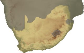
The Northern Cape is the largest and most sparsely populated province of South Africa. It was created in 1994 when the Cape Province was split up. Its capital is Kimberley. It includes the Kalahari Gemsbok National Park, part of the Kgalagadi Transfrontier Park and an international park shared with Botswana. It also includes the Augrabies Falls and the diamond mining regions in Kimberley and Alexander Bay.

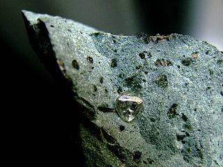
Hopetown is a town which lies at the edge of the Great Karoo in South Africa's Northern Cape province. It is situated on an arid slope leading down to the Orange River. The first diamond discovered in South Africa, the Eureka Diamond, was found at Hopetown.
Griqualand West is an area of central South Africa with an area of 40,000 km2 that now forms part of the Northern Cape Province. It was inhabited by the Griqua people – a semi-nomadic, Afrikaans-speaking nation of mixed-race origin, who established several states outside the expanding frontier of the Cape Colony. It was also inhabited by the pre-existing Tswana and Khoisan peoples.

Namaqualand is an arid region of Namibia and South Africa, extending along the west coast over 1,000 km (600 mi) and covering a total area of 440,000 km2 (170,000 sq mi). It is divided by the lower course of the Orange River into two portions – Little Namaqualand to the south and Great Namaqualand to the north.

Warrenton is an agricultural town of approximately 18,000 people in the Northern Cape province of South Africa, situated 70 kilometres (40 mi) north of Kimberley on the Vaal River.

The Harts River is a northern tributary of the Vaal River, which in turn is the largest tributary of the Orange River. Its source is in the North West Province, but the greater part of its basin is located in the Northern Cape Province, which it enters a few kilometers downstream from the Taung Dam.
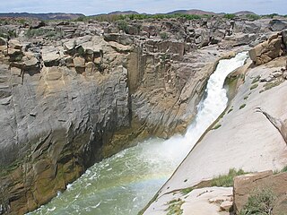
Augrabies Falls National Park is a national park located around the Augrabies Falls, about 120 km west of Upington in the Northern Cape Province, South Africa. It was established in 1966.
Kleinzee or Kleinsee is a small Village on the west coast of the Northern Cape province in South Africa,

A diamond rush is a period of feverish migration of workers to an area where diamonds were newly discovered. Major diamond rushes took place in the late 19th and early 20th centuries in South Africa and South-West Africa.
The Finsch Mine is an underground diamond mine in the Northern Cape. Located near Lime Acres, 160 km northwest of Kimberley, it was one of seven operations managed by De Beers Consolidated Mines (DBCM), formed in July 2004. Currently, it is owned by Petra Diamonds Pty Ltd.

Wilder Ranch State Park is a California State Park on the Pacific Ocean coast north of Santa Cruz, California. The park was formerly a dairy ranch, and many of the ranch buildings have been restored for use as a museum. There are no campgrounds; a day-use parking lot provides access to the museum. Dogs are prohibited on the trails, but many trails allow bikes and/or horses. The long trails and ocean views make the area a favorite of hikers, equestrians and mountain bikers. Public beaches continue to the north in Coast Dairies State Park.

Mamre Nature Garden is a 254-hectare (630-acre) nature reserve in Cape Town, South Africa, located on the city’s northern outskirts. The reserve has a high degree of biodiversity and preserving the endangered Atlantis Sand Fynbos vegetation type and the plants and animals that live in it. In addition, the reserve has an important cultural history.
Witzands Aquifer Nature Reserve is a 3,000-hectare (7,400-acre) protected natural area in Cape Town, South Africa, located on the city’s northern outskirts. This reserve protects an important part of Cape Town’s natural and cultural heritage, including the Atlantis Aquifer.

Daniëlskuil is a town in ZF Mgcawu District Municipality in the Northern Cape province of South Africa.
Ulco is a town in Frances Baard District Municipality in the Northern Cape province of South Africa. It lies 10 kilometers from the Vaal River.

The South African Sendinggestig Museum was established in 1977 and is currently situated in the centre of Cape Town, Western Cape, South Africa. It is a province-aided museum which receives support from the Government of the Western Cape Province.


