
Bloemfontein is the capital city of the province of Free State of South Africa; and, as the judicial capital of the nation, one of South Africa's three national capitals and is the seventh largest city in South Africa. Situated at an altitude of 1,395 m (4,577 ft) above sea level, the city is home to approximately 520,000 residents and forms part of the Mangaung Metropolitan Municipality which has a population of 747,431.

Durban is the third most populous city in South Africa—after Johannesburg and Cape Town—and the largest city in the South African province of KwaZulu-Natal. Located on the east coast of South Africa, Durban is famous for being the busiest port in the country. It is also seen as one of the major centres of tourism because of the city's warm subtropical climate and extensive beaches. Durban forms part of the eThekwini Metropolitan Municipality, which includes neighboring towns and has a population of about 3.44 million, making the combined municipality one of the biggest cities on the Indian Ocean coast of the African continent. It is also the second most important manufacturing hub in South Africa after Johannesburg. In 2015, Durban was recognised as one of the New7Wonders Cities. The city was heavily hit by flooding over 4 days from 18 April 2019, leading to 70 deaths and R650 000 000 in damage.

Randburg was an area located in the north west of Johannesburg, Gauteng, South Africa. Formerly a separate municipality, its administration devolved to the newly created City of Johannesburg Metropolitan Municipality, along with neighbouring Sandton and Roodepoort, in the late 1990s. During the transitional period of 1996–2000, Randburg was part of the Northern Metropolitan Local Council (MLC).

KwaDukuza is a town in KwaZulu-Natal, South Africa. In 2006, its official name was changed from Stanger to KwaDukuza, but the Zulu people in the area called it "Dukuza" well before then, and many South Africans still use the name "Stanger" "Stanger" has also been used on new road signs in the area.

Krugersdorp is a mining city in the West Rand, Gauteng Province, South Africa founded in 1887 by Marthinus Pretorius. Following the discovery of gold on the Witwatersrand, a need arose for a major town in the west of the reef. The government bought part of the Paardekraal farm and named the new town after the Transvaal president, Paul Kruger. Krugersdorp no longer has a separate municipal government after it was integrated into Mogale City Local Municipality along with surrounding towns. It is now the seat of government for Mogale City.
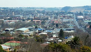
Bethlehem is a large town in the eastern Free State province of South Africa that is situated on the Liebenbergs river along a fertile valley just north of the Rooiberg Mountains on the N5 road.It is the fastest growing town in the Free state province, with its target of being the Fourth largest city after Kroonstad in balance.

Khayelitsha is a partially informal township in Western Cape, South Africa, located on the Cape Flats in the City of Cape Town. The name is Xhosa for OurNew Home. It is reputed to be the largest and fastest growing township in South Africa.

Tsakane (a.k.a.) Mashona is a township located in Ekurhuleni, Gauteng, South Africa. It was established during the early 1960s due to Apartheid's segregationist policies and was formally founded as a designated area. Tsakane is a Tsonga word which means joy or happiness.
Cato Manor is a working-class area located seven kilometers from the city centre of Durban, South Africa.

Punjai Puliampatti is a municipality in Sathyamangalam Taluk, Erode District in the Indian state of Tamil Nadu.

Malamulele can refer to the town of Malamulele or the area of Malamulele. Both the town and area are in the Limpopo province of South Africa and predominantly occupied by Tsonga people. Malamulele town has one provincial road and one regional road; the R81 to Giyani and the R524 to Thohoyandou respectively. Malamulele is flanked by two rivers, Levubu River (Rivhubye) to the west and Letaba River to the east, meanwhile the Shingwedzi River runs from Malamulele West to Malamulele East, joining the Limpopo River in Mozambique on its way to the Indian Ocean. Malamulele is the seat of the Collins Chabane Local Municipality.

Ottery is a suburb in Cape Town, South Africa. It is on the edge of the Southern Suburbs. The Youngsfield Military Base, Royal Cape Golf Club and Cape Town's 'official' China Town are located in the suburb. Every year the Youngsfield Military Base in Ottery hosts the Cape Argus Junior Cycle Tour on 12 March.

Lansdowne is a former whites only suburb in Cape Town, South Africa. situated 10 kilometres southeast of Cape Town City Centre, surrounded by the suburbs of Rondebosch East, Crawford, Wetton, Claremont, Kenwyn and Athlone. Lansdowne is served by a railway station of the same name, on the Cape Flats Line. During the apartheid era, Lansdowne was declared a area for whites only, but since the end of apartheid many Muslims, Coloureds and some black South Africans have settled in Lansdowne, racial transformation has taken place in Lansdowne, in a now post-apartheid South Africa.
Mtwalume is a settlement in Ugu District Municipality in the KwaZulu-Natal province of South Africa.
Senwabarwana is a town in the Blouberg Local Municipality of the Capricorn District Municipality in the Limpopo province of South Africa. The town is the seat of the Blouberg Local Municipality. It is located about 93 km northwest of the city Polokwane, on the route to Doringpad.
Ntuzuma is a town in eThekwini in the KwaZulu-Natal province of South Africa.
Tibane is a large, sprawling village in Ga-Matlala in the Polokwane Local Municipality of the Capricorn District Municipality of the Limpopo province of South Africa. It is located 55 km northwest of the city of Polokwane on the intersection between the R567 and Matlala roads.
Dududu is a small rural area in the south coast of the Ugu District in the KwaZulu-Natal province of South Africa. It is also referred to as Zembeni by locals. The area is primarily used for agriculture, i.e. the sugarcane plantations by the Illovo Sugar company.

Klein Mier is a small town in the Dawid Kruiper Local Municipality within the ZF Mgcawu District Municipality in the Northern Cape province of South Africa. 449 people reside in the town, 96.88% of whom are Coloured. Afrikaans is spoken by 98.22% of the population.
Brooklyn is a suburb of Cape Town, Western Cape with a population of 10,941 people. Brooklyn lies to the north of Maitland, south of the Atlantic Ocean, west of Air Force Base Ysterplaat and to the east of Paarden Eiland. The Black River flows through a section of Brooklyn.


