The Orange River is a river in Southern Africa. It is the longest river within the borders of South Africa and the Orange River Basin extends extensively from Lesotho into South Africa and Namibia to the north. It rises in the Drakensberg mountains in Lesotho, flowing westwards through South Africa to the Atlantic Ocean. The river forms part of the international borders between South Africa and Lesotho and between South Africa and Namibia, as well as several provincial borders within South Africa. Except for Upington, it does not pass through any major cities. The Orange River plays an important role in the South African economy by providing water for irrigation and hydroelectric power. The river was named the Orange River in honour of the Dutch ruling family, the House of Orange, by the Dutch explorer Robert Jacob Gordon. Other names include simply the word for river, in Khoekhoegowab orthography written as !Garib, which is rendered in Afrikaans as Gariep River with the intrusion of a velar fricative in place of the alveolar click, Groote River or Senqu River, derived from ǂNū "Black".

The Vaal River is the largest tributary of the Orange River in South Africa. The river has its source near Breyten in Mpumalanga province, east of Johannesburg and about 30 kilometres (19 mi) north of Ermelo and only about 240 kilometres (150 mi) from the Indian Ocean. It then flows westwards to its conjunction with the Orange River southwest of Kimberley in the Northern Cape. It is 1,120 kilometres (700 mi) long, and forms the border between Mpumalanga, Gauteng and North West Province on its north bank, and the Free State on its south.

Khoekhoen are the traditionally nomadic pastoralist indigenous population of southwestern Africa. They are often grouped with the hunter-gatherer San peoples. The designation "Khoekhoe" is actually a kare or praise address, not an ethnic endonym, but it has been used in the literature as an ethnic term for Khoe-speaking peoples of Southern Africa, particularly pastoralist groups, such as the !Ora, !Gona, Nama, Xiri and ǂNūkhoe nations.

The Northern Cape is the largest and most sparsely populated province of South Africa. It was created in 1994 when the Cape Province was split up. Its capital is Kimberley. It includes the Kalahari Gemsbok National Park, part of the Kgalagadi Transfrontier Park and an international park shared with Botswana. It also includes the Augrabies Falls and the diamond mining regions in Kimberley and Alexander Bay.

Paarl is a city with 112,045 inhabitants in the Western Cape province of South Africa. It is the third-oldest city and European settlement in the Republic of South Africa and the largest town in the Cape Winelands. Due to the growth of the Mbekweni township, it is now a de facto urban unit with Wellington. It is situated about 60 kilometres (37 mi) northeast of Cape Town in the Western Cape Province and is renowned for its haunting scenic beauty and deep viticulture and fruit-growing heritage.

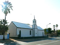
Upington is a town founded in 1873 and located in the Northern Cape province of South Africa, on the banks of the Orange River. The town was originally called Olijvenhoutsdrift, due to the abundance of olive wood trees in the area, but later renamed after Sir Thomas Upington, Attorney-General and then Prime Minister of the Cape. It originated as a mission station established in 1871 and run by Reverend Christiaan Schröder. The mission station now houses the town museum, known as the Kalahari Orange Museum. The museum is also the home of a donkey statue, which recognises the enormous contribution that this animal made to the development of the region during the pioneering days of the 19th century.

Kuruman is a town with just over 13,000 inhabitants in the Northern Cape province of South Africa. It is known for its scenic beauty and the Eye of Kuruman, a geological feature that brings water from deep underground. The abundance of water produce an unexpected swathe of green amidst the barren plains and is known as the Oasis of the Kalahari. It was at first a mission station of the London Missionary Society founded by Robert Moffat in 1821. It was also the place where David Livingstone arrived for his first position as a missionary in 1841. The Kuruman River, which is dry except for flash floods after heavy rain, is named after the town.

Namaqualand is an arid region of Namibia and South Africa, extending along the west coast over 1,000 km (600 mi) and covering a total area of 440,000 km2 (170,000 sq mi). It is divided by the lower course of the Orange River into two portions – Little Namaqualand to the south and Great Namaqualand to the north.

Jacobsdal is a small farming town in the Free State province of South Africa with various crops under irrigation, such as grapes, potatoes, lucerne and groundnuts. The town was layout in 1859 by Christoffel Jacobs on his farm Kalkfontein, and today houses 6,500 inhabitants.

Warrenton is an agricultural town of approximately 18,000 people in the Northern Cape province of South Africa, situated 70 kilometres (40 mi) north of Kimberley on the Vaal River.

The Harts River is a northern tributary of the Vaal River, which in turn is the largest tributary of the Orange River. Its source is in the North West Province, but the greater part of its basin is located in the Northern Cape Province, which it enters a few kilometers downstream from the Taung Dam.
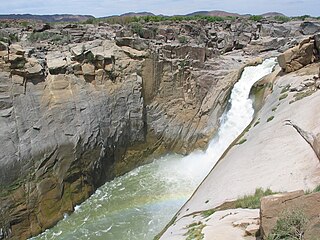
Augrabies Falls National Park is a national park located around the Augrabies Falls, about 120 km west of Upington in the Northern Cape Province, South Africa. It was established in 1966.

The Gariep Dam is located in South Africa, near the town of Norvalspont, bordering the Free State and Eastern Cape provinces. Its primary purpose is for irrigation, domestic and industrial use as well as for power generation.

Kirkwood is a town in the Eastern Cape Province of South Africa. It is situated on the banks of the Sundays River in the eponymously named Sundays River Valley, which forms part of the Sundays River Valley Municipality in the Sarah Baartman District Municipality of the Eastern Cape.

Groot Constantia is the oldest wine estate in South Africa and provincial heritage site in the suburb of Constantia in Cape Town, South Africa.

Kakamas is a town founded in 1898 and located in the Northern Cape province of South Africa, on the banks of the Orange River.

//Khara Hais Local Municipality was a local municipality in the Northern Cape province of South Africa. It fell within the ZF Mgcawu District Municipality and governs the town of Upington and surrounding rural areas. As of 2011 it the municipality has a population of approximately 93,500 people, and covers an area of 21,780 square kilometres (8,410 sq mi). The unusual spelling of the name comes from the original transcription of the Khwe language name, where the click consonant became "//".
Boegoeberg Dam is a gravity type dam on the Orange River, near Prieska, Northern Cape, South Africa. Building was started in 1926 and completed by 1933. Boegoeberg is named for the small tree Croton gratissimus, also known as Bergboegoe. Its primary purpose is for irrigation and it has a low hazard potential.

Murraysburg is an Afrikaans speaking town of approximately 5,000 people in the Western Cape province of South Africa. It is situated in the far northeast of the municipality, about 540 kilometres (340 mi) from the provincial capital Cape Town, and 80 kilometres (50 mi) west of Graaff-Reinet. It is governed as part of the Beaufort West Local Municipality within the Central Karoo District Municipality.

The Eye of Kuruman is a spring in the town of Kuruman in the province of Northern Cape, South Africa. One source states it is the largest known natural spring in the Southern Hemisphere. although the Te Waikoropupū Springs in Golden Bay, New Zealand has been reliably measured at an average flow some 60 times greater.