Bogacka Szklarnia

Last updated
Bogacka Szklarnia
Village
Country Flag of Poland.svg Poland
Voivodeship Opole
County Kluczbork
Gmina Kluczbork

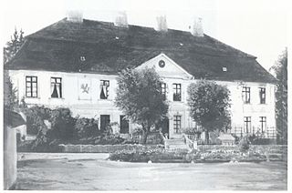
Bogacka Szklarnia [bɔˈɡat͡ska ˈʂklarɲa] (German : Bodländer Glashütte) is a village in the administrative district of Gmina Kluczbork, within Kluczbork County, Opole Voivodeship, in south-western Poland. From the Prussian-led unification of Germany in 1871 until the end of WWII, it was known as Glashütte in the administrative district of Upper Silesia (German: Oberschlesien) in Eastern Prussia, and settled predominantly by ethnic Slavs, Evangelical Protestants, and Silesian German farmers. No other evidence of protestant evangelical influence remains, except for the abandoned schoolhouse which still stands behind an overgrown copse of trees (Google maps 2018: 50°57'36.1"N 18°06'37.8"E). [1]

German language West Germanic language

German is a West Germanic language that is mainly spoken in Central Europe. It is the most widely spoken and official or co-official language in Germany, Austria, Switzerland, South Tyrol (Italy), the German-speaking Community of Belgium, and Liechtenstein. It is also one of the three official languages of Luxembourg and a co-official language in the Opole Voivodeship in Poland. The languages which are most similar to German are the other members of the West Germanic language branch: Afrikaans, Dutch, English, the Frisian languages, Low German/Low Saxon, Luxembourgish, and Yiddish. There are also strong similarities in vocabulary with Danish, Norwegian and Swedish, although those belong to the North Germanic group. German is the second most widely spoken Germanic language, after English.

Village Small clustered human settlement smaller than a town

A village is a clustered human settlement or community, larger than a hamlet but smaller than a town, with a population ranging from a few hundred to a few thousand. Though villages are often located in rural areas, the term urban village is also applied to certain urban neighborhoods. Villages are normally permanent, with fixed dwellings; however, transient villages can occur. Further, the dwellings of a village are fairly close to one another, not scattered broadly over the landscape, as a dispersed settlement.

Gmina Kluczbork is an urban-rural gmina in Kluczbork County, Opole Voivodeship, in south-western Poland. Its seat is the town of Kluczbork, which lies approximately 41 kilometres (25 mi) north-east of the regional capital Opole.

Related Research Articles

Teodorów, Oława County Village in Lower Silesian, Poland

Teodorów is a village in the administrative district of Gmina Domaniów, within Oława County, Lower Silesian Voivodeship, in south-western Poland.

Bąków, Kluczbork County Village in Opole, Poland

Bąków is a village in the administrative district of Gmina Kluczbork, within Kluczbork County, Opole Voivodeship, in south-western Poland. It lies approximately 8 kilometres (5 mi) east of Kluczbork and 43 km (27 mi) north-east of the regional capital Opole.

Bażany Village in Opole, Poland

Bażany is a village in the administrative district of Gmina Kluczbork, within Kluczbork County, Opole Voivodeship, in south-western Poland. It lies approximately 15 kilometres (9 mi) south of Kluczbork and 27 km (17 mi) north-east of the regional capital Opole.

Bogacica, Opole Voivodeship Village in Opole, Poland

Bogacica is a village in the administrative district of Gmina Kluczbork, within Kluczbork County, Opole Voivodeship, in south-western Poland. It lies approximately 6 kilometres (4 mi) west of Kluczbork and 37 km (23 mi) north-east of the regional capital Opole.

Bogdańczowice is a village in the administrative district of Gmina Kluczbork, within Kluczbork County, Opole Voivodeship, in south-western Poland.

Borkowice, Kluczbork County Village in Opole, Poland

Borkowice is a village in the administrative district of Gmina Kluczbork, within Kluczbork County, Opole Voivodeship, in south-western Poland. It lies approximately 7 kilometres (4 mi) south-west of Kluczbork and 35 km (22 mi) north-east of the regional capital Opole.

Krasków, Opole Voivodeship Village in Opole, Poland

Krasków is a village in the administrative district of Gmina Kluczbork, within Kluczbork County, Opole Voivodeship, in south-western Poland. It lies approximately 4 kilometres (2 mi) south-west of Kluczbork and 38 km (24 mi) north-east of the regional capital Opole.

Kuniów Village in Opole, Poland

Kuniów is a village in the administrative district of Gmina Kluczbork, within Kluczbork County, Opole Voivodeship, in south-western Poland. It lies approximately 5 kilometres (3 mi) south of Kluczbork and 38 km (24 mi) north-east of the regional capital Opole.

Ligota Dolna, Kluczbork County Village in Opole, Poland

Ligota Dolna is a village in the administrative district of Gmina Kluczbork, within Kluczbork County, Opole Voivodeship, in south-western Poland. It lies approximately 4 kilometres (2 mi) south-west of Kluczbork and 38 km (24 mi) north-east of the regional capital Opole.

Ligota Górna, Kluczbork County Village in Opole, Poland

Ligota Górna is a village in the administrative district of Gmina Kluczbork, within Kluczbork County, Opole Voivodeship, in south-western Poland.

Ligota Zamecka Village in Opole, Poland

Ligota Zamecka is a village in the administrative district of Gmina Kluczbork, within Kluczbork County, Opole Voivodeship, in south-western Poland. It lies approximately 3 kilometres (2 mi) south-east of Kluczbork and 40 km (25 mi) north-east of the regional capital Opole.

Nowa Bogacica is a village in the administrative district of Gmina Kluczbork, within Kluczbork County, Opole Voivodeship, in south-western Poland.

Smardy Dolne is a village in the administrative district of Gmina Kluczbork, within Kluczbork County, Opole Voivodeship, in south-western Poland.

Stare Czaple is a village in the administrative district of Gmina Kluczbork, within Kluczbork County, Opole Voivodeship, in south-western Poland.

Żabiniec, Kluczbork County Village in Opole, Poland

Żabiniec is a village in the administrative district of Gmina Kluczbork, within Kluczbork County, Opole Voivodeship, in south-western Poland. It lies approximately 8 kilometres (5 mi) south-west of Kluczbork and 35 km (22 mi) north-east of the regional capital Opole.

Gierałcice, Kluczbork County Village in Opole, Poland

Gierałcice is a village in the administrative district of Gmina Wołczyn, within Kluczbork County, Opole Voivodeship, in south-western Poland. It lies approximately 4 kilometres (2 mi) south of Wołczyn, 12 km (7 mi) west of Kluczbork, and 37 km (23 mi) north of the regional capital Opole.

Szum, Opole Voivodeship Village in Opole, Poland

Szum is a village in the administrative district of Gmina Wołczyn, within Kluczbork County, Opole Voivodeship, in south-western Poland. It lies approximately 7 kilometres (4 mi) south-west of Wołczyn, 15 km (9 mi) west of Kluczbork, and 35 km (22 mi) north of the regional capital Opole.

Barcino, Poland Village in Pomeranian, Poland

Barcino is a village in the administrative district of Gmina Kępice, within Słupsk County, Pomeranian Voivodeship, in northern Poland. It lies approximately 7 kilometres (4 mi) north-east of Kępice, 22 km (14 mi) south of Słupsk, and 110 km (68 mi) west of the regional capital Gdańsk.

Piaszczyte is a settlement in the administrative district of Gmina Bobolice, within Koszalin County, West Pomeranian Voivodeship, in north-western Poland.

Mężytki Settlement in West Pomeranian, Poland

Mężytki is a settlement in the administrative district of Gmina Stargard, within Stargard County, West Pomeranian Voivodeship, in north-western Poland.

References


Coordinates: 50°57′40″N18°5′58″E / 50.96111°N 18.09944°E / 50.96111; 18.09944

Geographic coordinate system Coordinate system

A geographic coordinate system is a coordinate system that enables every location on Earth to be specified by a set of numbers, letters or symbols. The coordinates are often chosen such that one of the numbers represents a vertical position and two or three of the numbers represent a horizontal position; alternatively, a geographic position may be expressed in a combined three-dimensional Cartesian vector. A common choice of coordinates is latitude, longitude and elevation. To specify a location on a plane requires a map projection.